
Strawberry is an unincorporated community and census-designated place (CDP) in Gila County, Arizona, United States. The population was 961 at the 2010 census.

Boronda is a census-designated place (CDP) in Monterey County, California, United States. The population was 1,710 at the 2010 census, up from 1,325 at the 2000 census. Boronda is located directly west of Salinas. Boronda is named after José Eusebio Boronda, a Californio ranchero, and located on the lands of his Rancho Rincón del Sanjón.
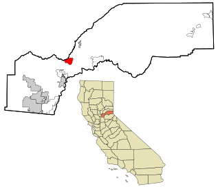
Meadow Vista is a census-designated place (CDP) in Placer County, California, United States. It is part of the Sacramento–Arden-Arcade–Roseville Metropolitan Statistical Area. The population was 3,217 at the 2010 census, up from 3,096 at the 2000 census.

Meadow Valley is a census-designated place (CDP) in Plumas County, California, United States. The population was 453 at the 2020 census, down from 464 at the 2010 census.

Isleta Village Proper is a census-designated place (CDP) in Bernalillo County, New Mexico, United States. The population was 491 at the 2010 census. It is part of the Albuquerque Metropolitan Statistical Area.

San Felipe Pueblo is a census-designated place (CDP) in Sandoval County, New Mexico, United States, and is located 10 miles (16 km) north of Bernalillo. As of the 2000 census, the CDP population was 2,080. It is part of the Albuquerque Metropolitan Statistical Area.
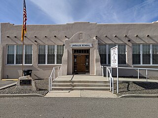
Jarales is a census-designated place (CDP) in Valencia County, New Mexico, United States. The population was 2,475 at the 2010 census. It is part of the Albuquerque Metropolitan Statistical Area.

Los Chavez is a census-designated place (CDP) in Valencia County, New Mexico. The population was 5,033 at the time of the 2000 census. It is part of the Albuquerque Metropolitan Statistical Area.

Los Trujillos-Gabaldon is a census-designated place (CDP) in Valencia County, New Mexico, United States. The population was 2,166 at the 2000 census. It is part of the Albuquerque Metropolitan Statistical Area.

Rio Communities North is a census-designated place (CDP) in Valencia County, New Mexico, United States. The population was 1,588 at the 2000 census. It is part of the Albuquerque Metropolitan Statistical Area.

Tome-Adelino is a former census-designated place (CDP) in Valencia County, New Mexico, United States. The population was 2,211 at the 2000 census. It is part of the Albuquerque Metropolitan Statistical Area. For the 2010 census, the CDP was split into the census-designated places of Tome and Adelino.

Valencia is a census-designated place (CDP) in Valencia County, New Mexico, United States. The population was 2,192 at the 2010 census. It is part of the Albuquerque Metropolitan Statistical Area.
Barker Ten Mile is a census-designated place (CDP) in Robeson County, North Carolina, United States. The population was 952 at the 2010 census. The land surrounding Barker Ten Mile includes multiple areas of local historic significance, the first being "The Meadows," which is the familial hunting grounds and horse pastures of the Goodes, French, McMillan, Sheppard and Godwin families, all of whom were prominent landholders, tobacco farmers and community members. Margeret Mclean, the wife of Angus Wilton Mclean, grew up in Barker Ten Mile. The collection of family land holdings originally stretched from what is now Meadowbrook Cemetery and north to Bee Gee Road and Meadow Road. From east to west, the property extended along the boundaries of Meadow Road and traversed I-95 near the current location of Robeson County Community College. Barry Godwin French, Margaret French McLean's father, was often referred to by the nickname "Bee Gee" and as such Bee Gee road, which bisected his land was named after him. Additionally, Barker Ten Mile is within the drainage area and immediately contains portions of Ten Mile Swamp and Saddle Tree Swamp, both of which are of cultural significance to the Lumbee. The Locklear family (Lumbee) and the Goodes were known to have hunted quail frequently together at the meadow and is reflective generally of the racial attitudes of the Barker Ten Mile Scots and Saddle Tree/Barker Ten Mile Lumbee.

Hyde is an unincorporated community and census-designated place (CDP) in Clearfield County, Pennsylvania, United States. The population was 1,303 at the 2020 census.
Yeagertown is a census-designated place (CDP) in Mifflin County, Pennsylvania, United States. The population was 1,035 at the 2000 census.

Mountainhome is a census-designated place (CDP) in Monroe County, Pennsylvania, United States. The population was 1,182 at the 2010 census.

Homestead Meadows South is a census-designated place (CDP) in El Paso County, Texas, United States. The population was 7,247 at the 2010 census. It is part of the El Paso Metropolitan Statistical Area. The ZIP Code encompassing the CDP area is 79938.
Antelope Hills is a census-designated place in Natrona County, Wyoming, United States. It is part of the Casper, Wyoming Metropolitan Statistical Area. The population was 97 at the 2010 census.
Meadow Acres is a census-designated place (CDP) in Natrona County, Wyoming, United States. It is part of the Casper, Wyoming Metropolitan Statistical Area. The population was 198 at the 2010 census.

Peru is a hamlet and census-designated place (CDP) within the town of Peru in Clinton County in the U.S. state of New York. The population of the CDP was 1,591 at the 2010 census, out of a population of 6,998 in the town as a whole.


