Rio Communities North, New Mexico

Last updated

Rio Communities North, New Mexico
CDP
Valencia County New Mexico Incorporated and Unincorporated areas Rio Communities North Highlighted.svg
Location of Rio Communities North, New Mexico
Usa edcp location map.svg
Red pog.svg
Rio Communities North, New Mexico
Location in the United States
Coordinates: 34°43′50″N106°41′10″W / 34.73056°N 106.68611°W / 34.73056; -106.68611
Country United States
State New Mexico
County Valencia
Area
  Total4.7 sq mi (12.3 km2)
  Land4.7 sq mi (12.3 km2)
  Water0.0 sq mi (0.0 km2)
Population
 (2000)
  Total1,588
  Density335.3/sq mi (129.4/km2)
Time zone UTC-7 (Mountain (MST))
  Summer (DST) UTC-6 (MDT)
Area code 505
FIPS code 35-63156

Rio Communities North is a census-designated place (CDP) in Valencia County, New Mexico, United States. The population was 1,588 at the 2000 census. It is part of the Albuquerque Metropolitan Statistical Area.

Contents

Geography

Rio Communities North is located at 34°43′50″N106°41′10″W / 34.73056°N 106.68611°W / 34.73056; -106.68611 (34.730465, -106.686085). [1]

According to the United States Census Bureau, the CDP has a total area of 4.7 square miles (12 km2), all land.

Demographics

As of the census [2] of 2000, there were 1,588 people, 550 households, and 451 families residing in the CDP. The population density was 335.3 inhabitants per square mile (129.5/km2). There were 591 housing units at an average density of 124.8 per square mile (48.2/km2). The racial makeup of the CDP was 70.09% White, 1.83% African American, 1.95% Native American, 0.88% Asian, 20.40% from other races, and 4.85% from two or more races. Hispanic or Latino of any race were 43.70% of the population.

There were 550 households, out of which 47.3% had children under the age of 18 living with them, 70.9% were married couples living together, 7.1% had a female householder with no husband present, and 18.0% were non-families. 12.5% of all households were made up of individuals, and 2.7% had someone living alone who was 65 years of age or older. The average household size was 2.89 and the average family size was 3.16.

In the CDP, the population was spread out, with 32.0% under the age of 18, 6.5% from 18 to 24, 37.0% from 25 to 44, 17.7% from 45 to 64, and 6.7% who were 65 years of age or older. The median age was 31 years. For every 100 females, there were 99.7 males. For every 100 females age 18 and over, there were 96.4 males.

The median income for a household in the CDP was $46,773, and the median income for a family was $46,471. Males had a median income of $40,685 versus $25,536 for females. The per capita income for the CDP was $17,745. About 2.8% of families and 3.9% of the population were below the poverty line, including 4.2% of those under age 18 and 5.2% of those age 65 or over.

Related Research Articles

<span class="mw-page-title-main">Underwood-Petersville, Alabama</span> Census-designated place in Alabama, United States

Underwood-Petersville is a census-designated place (CDP) in Lauderdale County, Alabama United States. It is part of the Florence - Muscle Shoals Metropolitan Statistical Area known as "The Shoals". As of the 2010 census, the population of the CDP is 3,247.

<span class="mw-page-title-main">Mesquite Creek, Arizona</span> CDP in Mohave County, Arizona

Mesquite Creek is an unincorporated community and census-designated place (CDP) in Mohave County, Arizona, United States. The population was 403 at the 2020 census.

<span class="mw-page-title-main">Citrus, California</span> Census-designated place in California, United States

Citrus is a census-designated place (CDP) in Los Angeles County, California, United States. It is located in the San Gabriel Valley between Azusa to the north and west, Glendora to the east, and Covina to the south. The population was 10,866 at the 2010 census, up from 10,581 at the 2000 census. Citrus is named after Citrus Avenue, which passes through the community.

<span class="mw-page-title-main">Palmona Park, Florida</span> Census-designated place in Florida, United States

Palmona Park is a census-designated place (CDP) in Lee County, Florida, United States. The population was 1,146 at the 2010 census, down from 1,353 at the 2000 census. It is part of the Cape Coral-Fort Myers, Florida Metropolitan Statistical Area.

<span class="mw-page-title-main">Chattanooga Valley, Georgia</span> CDP in Georgia, United States

Chattanooga Valley is a census-designated place (CDP) in Walker County, Georgia, United States. The population was 3,962 at the 2020 census. It is part of the Chattanooga, TN–GA Metropolitan Statistical Area.

<span class="mw-page-title-main">Highfield-Cascade, Maryland</span> CDP in Maryland, United States

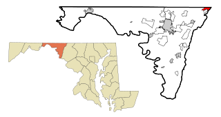
Highfield-Cascade is a census-designated place (CDP) in Washington County, Maryland, United States. The CDP encompasses two closely-spaced unincorporated communities, Highfield and Cascade, which are usually referred to separately. The population of the combined CDP was 1,141 at the 2000 census.

<span class="mw-page-title-main">St. James, Maryland</span> CDP in Maryland, United States

St. James is a census-designated place (CDP) in Washington County, Maryland, United States. The population was 1,657 at the 2000 census. It is also the home of St. James School, Hagerstown, a small, Episcopalian, boarding school. St. James was formerly named "Lydia."

<span class="mw-page-title-main">Teaticket, Massachusetts</span> Census-designated place in Massachusetts, United States

Teaticket is a census-designated place (CDP) in the town of Falmouth, Massachusetts. The population was 1,692 at the 2010 census.

<span class="mw-page-title-main">South Lockport, New York</span> CDP in New York, United States

South Lockport is a hamlet located in the Town of Lockport in Niagara County, New York, United States. The population was 8,234 at the 2010 census. It is part of the Buffalo–Niagara Falls Metropolitan Statistical Area.

<span class="mw-page-title-main">Holiday Valley, Ohio</span> Census-designated place in Ohio, United States

Holiday Valley is a census-designated place (CDP) in Clark County, Ohio, United States. The population was 1,480 at the 2020 census. It is part of the Springfield, Ohio Metropolitan Statistical Area.

<span class="mw-page-title-main">Leith-Hatfield, Pennsylvania</span> Census-designated place in Pennsylvania, United States

Leith-Hatfield is a census-designated place (CDP) in Fayette County, Pennsylvania, United States. The population was 2,546 at the 2010 census, down from 2,820 at the 2000 census. The twin villages of Leith and Hatfield are located in South Union Township.

Woodland Heights is a census-designated place (CDP) in Venango County, Pennsylvania, United States. The population was 1,402 at the 2000 census.

<span class="mw-page-title-main">Valley Green, Pennsylvania</span> CDP in Pennsylvania, United States

Valley Green is a census-designated place (CDP) in York County, Pennsylvania, United States. The population was 3,429 at the 2010 census.

<span class="mw-page-title-main">Loch Lomond, Virginia</span> Census-designated place in Virginia, United States

Loch Lomond is a census-designated place (CDP) in Prince William County, Virginia, United States. The population was 3,701 at the 2010 census. It is named after a loch in northern Scotland, Loch Lomond.

<span class="mw-page-title-main">Nisqually Reservation</span> CDP in Washington, United States

The Nisqually Reservation, also known as Nisqually Indian Reservation is a federally recognized Indian reservation in Thurston County, Washington, United States. The population was 668 at the 2020 census.

<span class="mw-page-title-main">Potter Lake, Wisconsin</span> CDP in Wisconsin, United States

Potter Lake is a census-designated place (CDP) in the town of East Troy, Walworth County, Wisconsin, United States. The population was 1,117 at the 2020 census.

Meadow Acres is a census-designated place (CDP) in Natrona County, Wyoming, United States. It is part of the Casper, Wyoming Metropolitan Statistical Area. The population was 198 at the 2010 census.

<span class="mw-page-title-main">Clinton (CDP), Massachusetts</span> CDP in Massachusetts, United States

Clinton is a census-designated place (CDP) in the town of Clinton in Worcester County, Massachusetts, United States. The population was 7,389 at the 2010 census.

<span class="mw-page-title-main">Peñasco, New Mexico</span> CDP in New Mexico, United States

Peñasco is a census-designated place (CDP) in Taos County, New Mexico. It is located along the scenic High Road to Taos. The population is estimated at 1,200 (2015).

<span class="mw-page-title-main">Bridgton (CDP), Maine</span> Census-designated place in Maine, United States

Bridgton is a census-designated place (CDP) in the town of Bridgton in Cumberland County, Maine, United States. The population was 2,071 at the 2010 census. It is part of the Portland–South Portland–Biddeford, Maine Metropolitan Statistical Area.

References

  1. "US Gazetteer files: 2010, 2000, and 1990". United States Census Bureau. February 12, 2011. Retrieved April 23, 2011.
  2. "U.S. Census website". United States Census Bureau . Retrieved January 31, 2008.