Tafua is a seaside village on the island of Savai'i in Samoa. It is situated on a peninsula on the southeast coast of the island in Palauli district. The population is 408.

Sataoa is a small village situated on the central south coast of Upolu island in Samoa. Like many villages in the country, Sataoa has two settlements, one inland and one by the coast. The population of Sataoa Uta is 924 and Sataoa Tai is 320.
Tuana'i is a small village on the central north coast of Upolu island in Samoa. It is situated to the west of Apia, the country's capital. The population is 1,247.

Mulinu'u is a small village situated on a tiny peninsula on Upolu island in Samoa. It became the site of the colonial administration in Samoa in the 1870s and continues to be the site for the Parliament of Samoa. It is located on the central north coast of the island and is part of the urban area comprising Apia, the country's capital.
Moata'a is a village on the island of Upolu in Samoa. It is situated on the central north coast of the island, to the east of the capital Apia. The village is in the political district of Tuamasaga.
Lauli'i is a village on the island of Upolu in Samoa. It is located on the central north coast of the island to the east of the capital Apia. Lauli'i is part of Vaimauga East Electoral Constituency which forms part of the larger political district of Tuamasaga.
Sala'ilua is a village on the island of Savai'i in Samoa. It is situated on the south coast of the island in Palauli district.
Apai is one of four small villages on Manono Island in Samoa. The village population is 111.
Salua is one of four small villages on Manono Island in Samoa. The village population is 201.
Pesega is a village on the island of Upolu in Samoa. It is located on western outskirts of Apia, the country's capita. Pesega is part of Faleata West Electoral Constituency which forms part of the larger political district of Tuamasaga.
Siutu is a village on the island of Savai'i in Samoa. It is situated on the southeast coast of the island in Palauli district.
Matautu is a village in the large traditional settlement of Lefaga in Samoa. The village is situated on the south west coast of Upolu island and lies within the political district of A'ana.
Gagaifo o le Vao is a village on the island of Upolu in Samoa. It is in the political district of A'ana.
Sāvaia is a village on the island of Upolu in Samoa. It is situated on the south west coast of the island in the political district of A'ana.
Lalovaea is a village on the island of Upolu in Samoa. It is situated on the north central side of the island near the country's capital Apia. The village is in the political district of Tuamasaga.
Tanugamanono is a village on the island of Upolu in Samoa. It is situated on the north central side of the island near the country's capital Apia. The village is in the political district of Tuamasaga.
Vaimoso is a village on the island of Upolu in Samoa. It is situated on the north central side of the island near the country's capital Apia. The village is in the political district of Tuamasaga.
Lepuia'i is one of four small villages on Manono Island in Samoa. The village population is 223.
Luatuanu'u is a village situated on the east side of Upolu island in Samoa. The village is part of Anoamaa West Electoral Constituency which is within the larger political district of Atua.
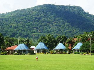
Lepea is a village on the island of Upolu in Samoa. The picturesque settlement of round Samoan houses built in a concentric pattern in large open grounds (malae) is situated 5mins drive west of the capital Apia on the north central coast of the island. It is part of the Tuamasaga electoral district.


