Vaimoso

Last updated
Vaimoso
Village
Samoa location map.svg
Red pog.svg
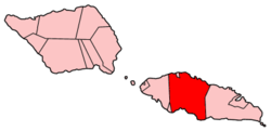
Vaimoso
Location in Samoa
Coordinates: 13°50′S171°45′W / 13.833°S 171.750°W / -13.833; -171.750
CountrySamoa
DistrictTuamasaga
Population
 (2016)
  Total2,465
Time zone UTC-11 (Samoa Time Zone)

Vaimoso is a village on the island of Upolu in Samoa. It is situated on the north central side of the island near the country's capital Apia. The village is in the political district of Tuamasaga. [1]

The population is 2465. [2]

Related Research Articles

<span class="mw-page-title-main">Samoa</span> Polynesian island country

Samoa, officially the Independent State of Samoa and until 1997 known as Western Samoa, is a Polynesian island country consisting of two main islands ; two smaller, inhabited islands ; and several smaller, uninhabited islands, including the Aleipata Islands. Samoa is located 64 km (40 mi) west of American Samoa, 889 km (552 mi) northeast of Tonga, 1,152 km (716 mi) northeast of Fiji, 483 km (300 mi) east of Wallis and Futuna, 1,151 km (715 mi) southeast of Tuvalu, 519 km (322 mi) south of Tokelau, 4,190 km (2,600 mi) southwest of Hawaii, and 610 km (380 mi) northwest of Niue. The capital and largest city is Apia. The Lapita people discovered and settled the Samoan Islands around 3,500 years ago. They developed a Samoan language and Samoan cultural identity.

<span class="mw-page-title-main">Apia</span> Capital of Samoa

Apia is the capital and only city of Samoa. It is located on the central north coast of Upolu, Samoa's second-largest island. Apia falls within the political district (itūmālō) of Tuamasaga.

Samoan culture tells stories of many different deities. There were deities of the forest, the seas, rain, harvest, villages, and war. There were two types of deities, atua, who had non-human origins, and aitu, who were of human origin.

<span class="mw-page-title-main">Upolu</span> Island in Samoa

Upolu is an island in Samoa, formed by a massive basaltic shield volcano which rises from the seafloor of the western Pacific Ocean. The island is 75 kilometres long and 1,125 square kilometres in area, making it the second largest of the Samoan Islands by area. With approximately 145,000 inhabitants, it is by far the most populous of the Samoan Islands. Upolu is situated to the southeast of Savai'i, the "big island". Apia, the capital, is in the middle of the north coast, and Faleolo International Airport at the western end of the island. The island has not had any historically recorded eruptions, although there is evidence of three lava flows, dating back only to between a few hundred and a few thousand years ago.

<span class="mw-page-title-main">Samoan Islands</span> Archipelago in the South Pacific Ocean

The Samoan Islands are an archipelago covering 3,030 km2 (1,170 sq mi) in the central South Pacific, forming part of Polynesia and of the wider region of Oceania. Administratively, the archipelago comprises all of the Independent State of Samoa and most of American Samoa. The land masses of the two Samoan jurisdictions are separated by 64 km (40 mi) of ocean at their closest points.

<span class="mw-page-title-main">Savaiʻi</span> Island in the Samoan Islands chain

Savaiʻi is the largest and highest island both in Samoa and in the Samoan Islands chain. The island is also the sixth largest in Polynesia, behind the three main islands of New Zealand and the Hawaiian Islands of Hawaii and Maui. While it is larger than the second main island, Upolu, it is significantly less populated.

<span class="mw-page-title-main">Taʻū</span> Island in the Manuʻa Islands

Taʻū is the largest inhabited island in the Manuʻa Islands and the easternmost volcanic island of the Samoan Islands. Taʻū is part of American Samoa. In the early 19th century, the island was sometimes called Opoun.

<span class="mw-page-title-main">Samoans</span> Indigenous Polynesian people of the Samoan Islands

Samoans or Samoan people are the indigenous Polynesian people of the Samoan Islands, an archipelago in Polynesia, who speak the Samoan language. The group's home islands are politically and geographically divided between the Independent State of Samoa and American Samoa, an unincorporated territory of the United States of America. Though divided by national border, the culture and language are the same.

<span class="mw-page-title-main">Swains Island</span> Atoll of American Samoa

Swains Island is a remote coral atoll in the Tokelau Islands in the South Pacific Ocean. The island is the subject of an ongoing territorial dispute between Tokelau and the United States, which has administered it as part of American Samoa since 1925. Privately owned by the family of Eli Hutchinson Jennings since 1856, Swains Island was used as a copra plantation until 1967. It has not been permanently inhabited since 2008 but has often been visited by members of the Jennings family, scientific researchers, and amateur radio operators.

<span class="mw-page-title-main">Tutuila</span> Largest island in American Samoa

Tutuila is the largest and most populous island of American Samoa and is part of the archipelago of the Samoan Islands. It is the third largest island in the Samoan Islands chain of the Central Pacific. It is located roughly 4,000 kilometers (2,500 mi) northeast of Brisbane, Australia and lies over 1,200 kilometers (750 mi) to the northeast of Fiji. It contains a large, natural harbor, Pago Pago Harbor, where Pago Pago, the capital of American Samoa, is situated. Pago Pago International Airport is also located on Tutuila. The island's land expanse is about 68% of the total land area of American Samoa. With 56,000 inhabitants, it is also home to 95% of the population of American Samoa. The island has six terrestrial and three marine ecosystems.

Fitiuta, also known as Fiti'uta or Maia, is a village on the northeast coast of Taʻū island, one of the Manuʻa Islands in American Samoa. As of the 2010 United States Census, it had a population of 153. The village of Fitiuta is made up of two hamlets: Maia and Leusoali'i, the latter of which is the most eastern area on the island. Historically, they were classified as villages. The town has two shops, a hotel and a church, which was recently built. Fitiuta Airport is located in the town.

<span class="mw-page-title-main">American Samoa</span> U.S territory in the South Pacific Ocean

American Samoa is an unincorporated territory of the United States located in the South Pacific Ocean, southeast of the island country of Samoa. Centered on 14.3°S 170.7°W, it is east of the International Date Line and the Wallis and Futuna Islands, west of the Cook Islands, north of Tonga, and some 500 kilometers (310 mi) south of Tokelau. American Samoa is the southernmost territory of the United States and one of two U.S. territories south of the Equator, along with the uninhabited Jarvis Island.

<span class="mw-page-title-main">Afono</span> Village in American Samoa, United States

Āfono is a village on the northeast coast of Tutuila Island, American Samoa. One of the island's more populous villages, it is located on the edge of Afono Bay, at the eastern edge of the National Park of American Samoa. It is connected by Highway 6 to Vatia, which lies along the coast to the northwest, and to Aua, on the edge of Pago Pago Harbor to the south via a winding stretch of highway which crosses the spine of the island.

Alao is a village on the narrow east coast of Tutuila Island, American Samoa. It is located close to the island's easternmost point, just to the north of Aunu'u Island. Alao is home to white sand beaches, and is one of the oldest settlements in all of American Samoa. It is located in Vaifanua County, American Samoa.

Āmouli is a village on the southeast coast of Tutuila Island, American Samoa at the narrowest point of the island. It is located to the west of 'Au'asi, immediately to the south of 'Aoa on the north coast. It was home to 920 residents at the 2010 U.S. Census, all of which were Pacific Islanders by race. It is located in Sa'Ole County.

<span class="mw-page-title-main">A'oloau</span> Village in American Samoa, United States

A'oloau is a village in the west of Tutuila Island, American Samoa. It is located inland, 5 miles (8 km) southwest of Pago Pago. It is also known as A’oloaufou, which means "new A’olou". An abandoned area in town by A'oloau Bay is known as A'oloautuai, which means Old A’oloau’. A'oloau's nickname is Nuu Puaolele which means the Fog Village.

ʻAoa is a village on the north-east coast of Tutuila Island, American Samoa. It is located on the north coast, close to the island's eastern tip, at a narrowing of the island and is connected by road with Amouli on the south coast. ʻAoa is the oldest site on Tutuila to yield ceramics. Located in a large U-shaped valley on the northeast coast of the island, ʻAoa sits on a wide, sandy beach fronted by a large, deep bay. Fresh water is supplied by a steady river which runs through the village. It is located in Vaifanua County.

ʻAuʻasi is a village in the east of Tutuila Island, American Samoa. One of the island's more populous villages, it is located on the south coast, close to the eastern tip of the island and to the smaller offshore island of Aunuʻu. It is located in Saʻole County.

The 2009 Samoa earthquake and tsunami took place on 29 September 2009 in the southern Pacific Ocean adjacent to the Kermadec-Tonga subduction zone. The submarine earthquake occurred in an extensional environment and had a moment magnitude of 8.1 and a maximum Mercalli intensity of VI (Strong). It was the largest earthquake of 2009. The earthquake initiated with a normal-faulting event with a magnitude of 8.1. Within two minutes of the earthquake rupture, two large magnitude 7.8 earthquakes occurred on the subduction zone interface. The two magnitude 7.8 earthquakes had a combined magnitude equivalent to 8.0. The event can be considered a doublet earthquake.

<span class="mw-page-title-main">Vatia, American Samoa</span> Village in American Samoa, United States

Vatia is a village on Tutuila Island in American Samoa. It is a north shore village located on Vatia Bay. The road to Vatia, American Samoa Highway 006, is the only road going through National Park of American Samoa. Vatia is a scenic community at the foot of Pola Ridge and surrounded by the national park. It is only reached by Route 6 which traverses the national park before reaching Vatia. There was once a hiking trail over Maugaloa Ridge from Leloaloa, but since the completion of Route 6, this trail is now overgrown. It is home to a beach, and panoramic views of jungle-covered peaks surround the village on all sides. Vatia is the center of the Tutuila-section of National Park of American Samoa. It is located in Vaifanua County.

References

  1. "Samoa Territorial Constituencies Act 1963". Pacific Islands Legal Information Institute. Archived from the original on 5 June 2011. Retrieved 16 December 2009.
  2. "Census 2016 Preliminary count" (PDF). Samoa Bureau of Statistics. p. 7. Retrieved 2 August 2021.