Malie

Last updated

Malie is a village on the island of Upolu in Samoa. It is located on the north coast in the Electoral Constituency (Faipule District) of Sagaga Le Usoga which forms part of the larger political district of Tuamasaga. [1] The village has been a traditional headquarters for the Malietoa, one of the four paramount families and royal titles of Samoa. [2] The village has a population of 2247. [3]

Contents

Geography

Malie's western border lies by the western bay at Vaifoa, next to Fale'ula. Between the two villages is the promontory Satea. Another five minutes further west and inland lies Malie itself with its large malae, on which lies the large stone tomb of Malietoa Molī, father of Malietoa Laupepa. Immediately adjacent is Lalau, forming Malie's boundary.
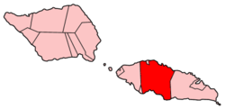
Tuamasaga

One of four Paramount Chiefs of Samoa, Malietoa Tanumafili I Malietoa Tanumafili I.jpg
One of four Paramount Chiefs of Samoa, Malietoa Tanumafili I

As part of Tuamasaga, both Malie and Afega play the leading role in governance of the region and are addressed collectively as "Tuisamau ma Auimatagi" in matters of national importance, particularly when Pule and Tumua (Samoa's orator chiefs) are gathered in ceremony. Afega holds preeminence as the administrative capital of Tuamasaga while Malie holds equal preeminence as the seat of the Malietoa as well as the Auimatagi and the faleupolu of Malie. The great fono (council) of Tuamasaga meets at Malie during times of peace and is why the malae at Malie is called malae o le filemu (gathering place of peace). In many affairs – especially during war – Auimatagi is called upon on behalf of Malie in deliberations to determine whether and when and where the fono is to take place.

Malietoa

The residential grounds of the Malietoa are called 'Feagaimaleata' ("together with the dawn"). Further inland one can still see the stones on which the heads of the human sacrifices were smashed prior to being prepared for Malietoa Faigā's meals.

The current Malietoa, Malietoa Molī, was bestowed the honor in Malie in August 2018. The right of the matai of Malie to bestow the honor came under legal challenges, with criminal contempt of court charges being laid against sixteen chiefs, though those challenges were ultimately dismissed. [4] [5] The matter has since been resolved with all parties concerned acquiescing to the judgement rendered by the Lands & Titles Court together with the wishes of both Afega and Malie to have Malietoa Molī continue as the current holder of the paramount title. [6]

Fa'alupega: Honorific Salutations of Malie

Tulouna a Auimatagi

Tulouna a lo outou to'afitu

Tulouna Fa'amausili ma Mauala'ivao

Tulouna o lou alii, o lau Susuga a Malietoa [6]

Related Research Articles

Politics of Samoa

Politics of Samoa takes place in a framework of a parliamentary representative democratic state whereby the Prime Minister of Samoa is the head of government. Existing alongside the country's Western styled political system is the fa'amatai chiefly system of socio-political governance and organisation, central to understanding Samoa's political system.

Malietoa Tanumafili II

Malietoa Tanumafili II, addressed Susuga Malietoa Tanumafili II, was the Malietoa, the title of one of Samoa's four paramount chiefs, and the head of state, or O le Ao o le Malo, a position that he held for life, of Samoa from 1962 to 2007. He was co-head of state in 1962 with the tama-a-'aiga Tupua Tamasese Mea'ole and became the sole head of state on 15 April 1963 upon the death of his counterpart. At the time of his death, he was the oldest national leader in the world, and was also the last incumbent president-for-life in the world.

Districts of Samoa Overview of the districts of Samoa

Samoa is made up of eleven itūmālō. These are the traditional eleven districts that were established well before European arrival. Each district has its own constitutional foundation (faavae) based on the traditional order of title precedence found in each district's faalupega.

Aʻana District in Samoa

Aʻana is a district of Samoa. It is on the western third of Upolu island, with a small exclave surrounded by Aiga-i-le-Tai. It has an area of 193 km² and a population of 23,265. The main centre is Leulumoega.

Atua (district) Place in Samoa

Ātua is an ancient political district of Samoa, consisting of most of the eastern section of Upolu and the island Tutuila. Ātua is ruled by the Tui Ātua together with the group of six senior orators of Lufilufi and 13 senior matai from throughout Ātua, comprising the Fale Ātua. The fono (meeting) of Atua's rulers takes place in Lufilufi on the great malae of Lalogafu'afu'a.

Tuamasaga District in Samoa

Tuamāsaga is a district of Samoa, with a population of 95,907. The geographic area of Tuamasaga covers the central part of Upolu island.

Faʻasaleleaga District in Samoa

Faʻasaleleaga is a district of Samoa situated on the eastern side of Savaiʻi island. It has a population of 13,566.

Malietoa Laupepa Malietoa

Susuga Malietoa Laupepa was the ruler (Malietoa) of Samoa in the late 19th century.

Aua, American Samoa Village in American Samoa, United States

Aūa is a village on Tutuila Island in American Samoa. It is located along American Samoa Highway 001, and is the southern terminus of American Samoa Highway 006. Aūa is located at the foothills of Mount Peiva on the eastern side of Pago Pago Bay. The hamlet of Leloaloa is also a part of Aūa.

Malietoa Tanumafili I Malietoa

Susuga Malietoa Tanumafili I was the Malietoa in Samoa from 1898 until his death in 1939.

Le Susuga Malietoa Talavou Tonumaipeʻa was installed as "King" of Samoa to the western world on August 28, 1879 until his death on November 9, 1880. Since Malietoa Talavou's half brother's death, Malietoa Moli in 1860, ongoing wars due to power and authority struggle between Talavou and Laupepa over the next Malietoa title holder and the gaining of support by the districts of Samoa. Family rivalry existed as did a 30-year age difference drew a wedge between Malietoa Laupepa and Malietoa Talavou. They were known to be longtime rivals over the Malietoa title.

Malietoa One of Samoas four paramount chiefs

Mālietoa is a state dynasty and one of the four paramount chiefly titles of Samoa. Literally translated as "great warrior", the title's origin comes from the final words of the Tongan warriors as they were fleeing on the beach to their boats, "Malie To`a, Malo e tau...".

Mulinuu

Mulinu'u is a small village situated on a tiny peninsula on Upolu island in Samoa. It became the site of the colonial administration in Samoa in the 1870s and continues to be the site for the Parliament of Samoa. It is located on the central north coast of the island and is part of the urban area comprising Apia, the country's capital.

Solosolo Village in Atua, Samoa

Solosolo is a village on the northeast coast of Upolu island in Samoa. The village is in the political district of Atua and has a population of 1851. It is one of the prominent settlements in the area with the largest population in its electoral constituency of Anoama'a West.

Falefa Place in Atua, Samoa

Falefā is located on the north eastern coast of Upolu island in Samoa. It was the ancient capital during the ‘Malo’ (‘government’) of Tupu Tafa'ifa (King) Fonoti. After having defeated his siblings Va'afusuaga and Samalaulu for control of Samoa, King Fonoti chose to rule from his new seat in Falefa, an honour remembered in its faalupega to this day.

<i>Faʻamatai</i> Chiefly system of Samoa

Fa'amatai is the indigenous political ('chiefly') system of Samoa, central to the organization of Samoan society. It is the traditional indigenous form of governance in both Samoas, comprising American Samoa and the Independent State of Samoa. The term comprises the prefix fa'a and the word matai.

Safotulafai Village District in Faasaleleaga, Samoa

Safotulafai is a traditional village at the east end of Savai'i island with historical and political significance in Samoa's history. It is the traditional center of the island of Savaii, now became the center of Fa'asaleleaga political district.

Muagututagata Peter Ah Him is a Samoan politician and former member of the Legislative Assembly of Samoa. He represented the constituency of Sagaga-Le-Usoga and was a member of the Human Rights Protection Party. He is the younger brother of Maualaivao Pat Ah Him.

Ama is a title originating c. 1400 AD, and bestowed upon the paramount chief and commander in war of the district of Safata, situated south of the island of Upolu, within the country of Samoa. It is a hereditary title. The title originated from Lotofaga, a village within the Safata district. Lotofaga is a village that sits in the middle of the Safata Bay. The village has been described as the following: 'Here the surf is sometimes so wild that one cannot sleep because of the roar; therefore it is called Galutatu'. It is also known as Le-Faga-o-Alii, translated in Samoan as 'The Bay of Chiefs'. This is in reference to the Ama that resides there. Lotofaga is traditionally known to be a village of refuge for those in need as well as a place to observe and learn of Samoan chief customs and etiquette.

Lepea

Lepea is a village on the island of Upolu in Samoa. The picturesque settlement of round Samoan houses built in a concentric pattern in large open grounds (malae) is situated 5mins drive west of the capital Apia on the north central coast of the island. It is part of the Tuamasaga electoral district.

References

  1. "Samoa Territorial Constituencies Act 1963". Pacific Islands Legal Information Institute. Archived from the original on 5 June 2011. Retrieved 31 January 2010.
  2. Meleisea, Malama (1987). The making of modern Samoa. University of the South Pacific. p. 22. ISBN   982-02-0031-8 . Retrieved 31 January 2010.
  3. "Census 2016 Preliminary count" (PDF). Samoa Bureau of Statistics. p. 7. Retrieved 2 August 2021.
  4. "Criminal charges sought for Malietoa title bestowal". RNZ. 2018-08-21. Retrieved 2019-08-14.
  5. "Samoa court dismisses Malietoa contempt charges". RNZ. 2019-05-27. Retrieved 2019-08-14.
  6. 1 2 Kramer, Dr. Augustin (1999). The Samoa Islands. Auckland: Pasifika Press. p. 290. ISBN   0908597177.

Coordinates: 13°48′S171°49′W / 13.800°S 171.817°W / -13.800; -171.817