Related Research Articles
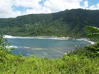
Va'a-o-Fonoti is a district on the north east coast of Upolu Island in Samoa, with a population of 1,621, making it the least populated district in the country.
A'ufaga is a small village on the southeast end of Upolu island in Samoa. The village is part of the electoral constituency Lepa which is included in the larger political district of Atua.
Siumu is a village on the central south coast of Upolu island in Samoa. The population is 1183. There is also a sub-village Siumu Uta which has a population of 304.

Sataoa is a small village situated on the central south coast of Upolu island in Samoa. Like many villages in the country, Sataoa has two settlements, one inland and one by the coast. The population of Sataoa Uta is 1121 and Sataoa Tai is 239.
Tuana'i is a small village on the central north coast of Upolu island in Samoa. It is situated to the west of Apia, the country's capital. The population is 1407.
Moata'a is a village on the island of Upolu in Samoa. It is situated on the central north coast of the island, to the east of the capital Apia. The village is in the political district of Tuamasaga.
Lauli'i is a village on the island of Upolu in Samoa. It is located on the central north coast of the island to the east of the capital Apia. Lauli'i is part of Vaimauga East Electoral Constituency which forms part of the larger political district of Tuamasaga.
Pesega is a village on the island of Upolu in Samoa. It is located on western outskirts of Apia, the country's capita. Pesega is part of Faleata West Electoral Constituency which forms part of the larger political district of Tuamasaga.
Poutasi is a village on the south east coast of Upolu island in Samoa. The population is 395. The village is part of Falealili Electoral Constituency in the larger political district of Atua. Poutasi was extensively damaged by the 2009 Samoa earthquake and tsunami.
Safa'atoa is a village on the island of Upolu in Samoa. It is situated on the south west side of the island. Safa'atoa is in the electoral constituency of Lefaga & Falese'ela which forms part of the larger political district A'ana.
Gagaifo o le Vao is a village on the island of Upolu in Samoa. It is in the political district of A'ana.
Magiagi is a village on the island of Upolu in Samoa. It is situated on the central north coast of the island. The village is in the political district of Tuamasaga.
Lalovaea is a village on the island of Upolu in Samoa. It is situated on the north central side of the island near the country's capital Apia. The village is in the political district of Tuamasaga.
Fa'ato'ialemanu is a village on the island of Upolu in Samoa. It is situated on the north central side of the island and is part of the greater Apia area. The village has a population of 841.
Vaimoso is a village on the island of Upolu in Samoa. It is situated on the north central side of the island near the country's capital Apia. The village is in the political district of Tuamasaga.
Matatufu is a small village on south east end of Upolu island in Samoa. The village is part of Lotofaga Electoral Constituency which is within the larger political district of Atua.
Saleapaga is a village on the south east coast of Upolu island in Samoa. The village is part of Lepa Electoral Constituency which is within the larger political district of Atua.
Fasito'o Tai is a village situated on the northwest coast of Upolu island in Samoa. The village is part of A'ana Alofi III Electoral Constituency which formas part of the larger A'ana political district.
Fasito'o Uta is a village situated on the northwest coast of Upolu island in Samoa. The village is part of A'ano Alofi I Electoral Constituency which forms part of the larger A'ana political district.
Luatuanu'u is a village situated on the east side of Upolu island in Samoa. The village is part of Anoamaa West Electoral Constituency which is within the larger political district of Atua.
References
- ↑ "Census 2016 Preliminary count" (PDF). Samoa Bureau of Statistics. p. 7. Retrieved 2 August 2021.
- ↑ "Samoa Territorial Constituencies Act 1963". Pacific Islands Legal Information Institute. Archived from the original on 5 June 2011. Retrieved 19 December 2009.
13°50′44.24″S171°50′0″W / 13.8456222°S 171.83333°W Coordinates: 13°50′44.24″S171°50′0″W / 13.8456222°S 171.83333°W
| Villages |  | |
|---|---|---|
| Notable landmarks | ||
| Archaeology in Samoa |
| |
| Education & Libraries | ||
| Environment | ||
| Electoral constituencies: Faipule Districts |
| |
| | This article about a geographical location in Samoa is a stub. You can help Wikipedia by expanding it. |