M57 (Johannesburg)

Last updated

Joburg road M57.svg
Metropolitan route M57
Route information
Maintained by Johannesburg Roads Agency and Department of Roads and Transport (Gauteng)
Length42.2 km (26.2 mi)
Major junctions
South endSA road R29.svgM37 ZAF jct.svg R29  / M37 Shamrock Road, Primrose, Germiston
Major intersectionsM39 ZAF jct.svg M39 Lazarus Mawela Road, Woodmere, Germiston
SA road N12 jct.svg N12, Elandsfontein, Germiston
M44 ZAF jct.svg M44 Jet Park Road/North Reef Road, Elandsfontein, Germiston
M41 ZAF jct.svg M41 Griffiths Road, Jet Park, Boksburg
M99 ZAF jct.svg M99 Electron Avenue, O.R. Tambo, Kempton Park
M16 ZAF jct.svg M16 Andre Greyvenstein Road, Rhodesfield, Kempton Park
M32 ZAF jct.svg M32 Petrus "Chilly" Magagula Road, Kempton Park
M32 ZAF jct.svg M32 Plane Road, Kempton Park
M96 ZAF jct.svg M96 Long Street, Kempton Park
M90 ZAF jct.svg M90 C.R.Swart Drive, Kempton Park
M45 ZAF jct.svg M45 Van Riebeeck Road, Kempton Park
M89 ZAF jct.svg M89 Elgin Road, Birchleigh, Kempton Park
M43 ZAF jct.svg M43 Vlei Street, Glen Marais, Kempton Park
SA road R23.svg R23 High Road, Esselen Park, Kempton Park
SA road R25.svg R25 Modderfontein Road, Esselen Park, Kempton Park
SA road R562.svg R562 Winnie Madikizela-Mandela Road, Tembisa
M31 ZAF jct.svg M31 Nellmapius Drive, Irene
North endM10 ZAF jct.svg M10 Solomon Mahlangu Drive, Waterkloof, Pretoria
Location
Country South Africa
Major cities Germiston, Kempton Park, Thembisa, Olifantsfontein, Pretoria
Highway system
M56 ZAF jct.svg M56 M59 ZAF jct.svg M59

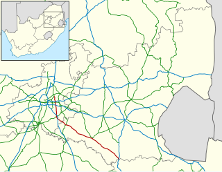
The M57 is a major metropolitan route in Greater Johannesburg, South Africa. A north/south route, it connects Germiston with the south-eastern suburbs of Pretoria via Kempton Park and Olifantsfontein. For most of its length, it is an alternative route to the R21 freeway.

Route

The M57 begins at a 4-way-junction with the R29 and M37 in Primrose (north of Germiston City Centre). [1] :111 It starts by heading east-north-east as Pretoria Road and meets the M39 (Lazarus Mawela Road) before crossing the N12 highway (Johannesburg-Witbank Highway) as Ntemi Ncwane Road (formerly Kraft Road [2] [3] ). [1] :86 Just after the N12 junction, it reaches a junction with the M44 (North Reef Road) in the industrialised suburb of Elandsfontein. [1] :444 It joins the M44 road eastwards up to the next junction, where it becomes its own road northwards. [1] :87

It heads northwards as Jet Park Road through Jet Park to meet the M41 (Griffiths Road) at a t-junction, with the M41 leading to the R21 freeway and to the South African Airways headquarters in the east. [1] :87

From the M41 junction, it is parallel to the R21 freeway northwards, and it has the industrialized suburb of Isando to its left and the outskirts of O.R. Tambo International Airport to its right. [1] :61 It meets the M99 (Electron Avenue), which provides an entrance into the airport. [1] :61 It then, as a flyover, crosses the R24 freeway as Pretoria Road and immediately after, it meets the eastern terminus of the M16 (Andre Greyvenstein Road) as it enters the suburb of Rhodesfield in Kempton Park. [1] :61 Now, as Pretoria Road, it is the main road through Kempton Park's CBD and is intersected from the east by the M32 at Petrus “Chilly” Magagula Road (formerly Pomona Road [3] [2] ) and the two are co-signed for 400 metres before the M32 becomes Plane Road westwards while the M57 continues northwards through the CBD of Kempton Park. [1] :61

Crossing the M90 (C.R. Swart Drive) at Kempton Park Civic Center, it leaves the Kempton Park CBD and enters the city's northern suburbs, with Edleen to its left and Kempton Park extension 2, 3 and 4 to its right. [1] :39 After the M45 (Van Riebeeck Road) t-junction, it has Allen Grove to its right and Van Riebeeck Park to its left. After the Beukes Road t-junction, it has Glen Marais to its right and Birchleigh to its left. [1] :39 Just after, it meets the northern terminus of the M43 (Vlei Street) at a t-junction. [1] :21

North-east of Birchleigh, near Esselen Park on the outskirts of Kempton Park, the M57 route meets the northern terminus of the R23 (High Road) from the east and then, at the next junction, meets the R25 (Modderfontein Road) from the west. [1] :22

The R25 and M57 are co-signed northwards for 800 metres, with Esselen Park and the Witfontein extension to its left, before the R25 breaks-off and becomes the road eastwards towards Bapsfontein at a busy 4-way-junction, with the road westwards providing access to Thembisa South.

Continuing northwards, the M57 trails the Thembisa township to its west and the parallel R21 freeway to its east before intersecting the east/west R562 (Winnie Madikizela-Mandela Road) as Goedehoop Avenue just south-east of Clayville (also known as Olifantsfontein), where Winnie Madikizela-Mandela Road provides access to the Clayville CBD. The M57 continues northwards, passing through Clayville East and through rural agricultural suburbs before leaving Ekurhuleni and crossing the municipal border into Tshwane and reaching the outskirts of Irene, crossing to the other side of the R21 freeway as a flyover.

Crossing the M31 Nellmapius Drive, it enters Rietvallei Park and afterwards, it enters Elardus Park, becomes Boeing Street and the M57 ends shortly thereafter at a t-junction with the M10 Solomon Mahlangu Drive at Waterkloof in Pretoria.

Related Research Articles

<span class="mw-page-title-main">Kempton Park, South Africa</span> Place in Gauteng, South Africa Postal address 1619

Kempton Park is a city in the East Rand region of Gauteng province, South Africa. It is part of the City of Ekurhuleni Metropolitan Municipality. It is situated south of Tembisa, one of the largest townships in South Africa, which is also part of Ekurhuleni. South Africa's busiest airport, O. R. Tambo International Airport is located in Kempton Park.

<span class="mw-page-title-main">R21 (South Africa)</span> Road in South Africa

The R21 is a major north–south provincial route in eastern Gauteng Province, South Africa. Built in the early 1970s, it remains one of two freeways linking Pretoria with Johannesburg, via the R24. As the eastern of the two freeways, it links the Pretoria city centre with OR Tambo International Airport, the N12 freeway, and Boksburg. Between the Solomon Mahlangu Drive on-ramp in Monument Park, Pretoria, and the N12 in Boksburg, the R21 is an 8 lane highway and motorway (freeway), with 4 lanes in each direction. It has off-ramps leading to Irene, Olifantsfontein, Benoni, and Kempton Park, including a partial offramp to Atlas Road. The route intersects the N1 highway near Centurion, the R24 near the airport, the N12 and N17 in Boksburg, and the N3 near Vosloorus on the East Rand, where it ends. The section from the N12 to the N3 is not a freeway. The R21 is also designated as the P157.
<span class="mw-page-title-main">R23 (South Africa)</span>

The R23 is a provincial route in South Africa that links Benoni with Volksrust via Brakpan, Heidelberg and Standerton.

<span class="mw-page-title-main">R24 (South Africa)</span> Road in South Africa

The R24 is a major East-West provincial route in the Gauteng and North West provinces that links OR Tambo International Airport with Rustenburg via Johannesburg, Krugersdorp and Magaliesburg. The process of renaming the streets and freeway that form the route from Krugersdorp eastward to OR Tambo International after anti-apartheid stalwart Albertina Sisulu was completed in 2013.

<span class="mw-page-title-main">R25 (South Africa)</span> Road in South Africa

The R25 is a provincial route in South Africa that connects Johannesburg with Groblersdal via Kempton Park, Bapsfontein and Bronkhorstspruit.

The R103 is a Regional Route in South Africa that is the designation for some of the old sections of roads that were previously the N3, prior to upgrading. It only has 3 sections, from Hillcrest to Ladysmith, from Warden to Villiers and from Heidelberg to Johannesburg.

<span class="mw-page-title-main">Thembisa</span> Place in Gauteng, South Africa

Thembisa, formerly Tembisa, is a large township situated to the north of Kempton Park on the East Rand, Gauteng, South Africa. It was established in 1957 when black people were resettled from Alexandra and other areas in Edenvale, Kempton Park, Midrand and Germiston.

<span class="mw-page-title-main">N12 (South Africa)</span> National road in South Africa

The N12 is a national route in South Africa which runs from George through Beaufort West, Kimberley, Klerksdorp and Johannesburg to eMalahleni.

The R562 is a Regional Route in Gauteng, South Africa that connects Diepsloot with Olifantsfontein (Clayville) and Thembisa via Midrand.

The M43 is a major metropolitan road in Greater Johannesburg, South Africa which begins in Vosloorus and heads northwards to Birchleigh, Kempton Park on the East Rand.

The M32 is a short metropolitan route in Greater Johannesburg, South Africa. The entire route is in the City of Ekurhuleni Metropolitan Municipality. It goes from the western part of Kempton Park eastwards to the northern parts of Benoni.

The M37 is a metropolitan route in Greater Johannesburg, South Africa. It connects the N3 at Greenstone Shopping Mall with Katlehong via Edenvale and Germiston.

The M39 is a long metropolitan route in Greater Johannesburg, South Africa. It connects Kyalami with Germiston via Midrand, Kempton Park & Isando.

The M44 is a short metropolitan route in Greater Johannesburg, South Africa. It connects the Elandsfontein industrial suburb in the northern part of Germiston with Petit in the north-eastern part of Benoni.

The M45 is a long metropolitan route in Greater Johannesburg, South Africa. It connects Kempton Park with Dunnottar via Benoni, Brakpan, KwaThema and Tsakane. The entire route is in the City of Ekurhuleni Metropolitan Municipality.

The M84 is a short metropolitan route in Greater Johannesburg, South Africa. The entire route is within the city of Kempton Park.

The M96 is a short metropolitan route in Greater Johannesburg, South Africa. The entire route is within the CBD of Kempton Park and consists of two one-way streets.

The M99 is a short metropolitan route in Greater Johannesburg, South Africa. For its entire route, it parallels the R24 highway in the City of Ekurhuleni Metropolitan Municipality.

Olifantsfontein, also known as Clayville, is a small town on the East Rand in the Gauteng Province of South Africa. It is located at the north-western corner of the City of Ekurhuleni Metropolitan Municipality, just north of the Thembisa township. As of the 2011 Census, the town has a population of 14,526 people.

The M18 road is a long metropolitan route in Gauteng, South Africa. It connects Pretoria with Thembisa via Centurion and Olifantsfontein.

References

  1. 1 2 3 4 5 6 7 8 9 10 11 12 13 Street Guide Witwatersrand (8th ed.). MapStudio. 1996.
  2. 1 2 "44 name changes for Ekurhuleni streets". Germiston City News. 30 October 2021. Retrieved 2 April 2022.
  3. 1 2 Staff Writer. "These 44 roads in Ekurhuleni are getting a name change – what you need to know – BusinessTech" . Retrieved 2 April 2022.