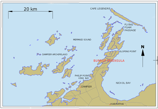
Dampier is a major industrial port in the Pilbara region in the northwest of Western Australia. It is located near the city of Karratha and Port Walcott.

Wewak is the capital of the East Sepik province of Papua New Guinea. It is on the northern coast of the island of New Guinea. It is the largest town between Madang and Jayapura. It is the see city (seat) of the Roman Catholic Diocese of Wewak.

Denham is the administrative town for the Shire of Shark Bay, Western Australia. At the 2016 census, Denham had a population of 754. Located on the western coast of the Peron Peninsula 831 kilometres (516 mi) north of Perth, Denham is the westernmost publicly accessible town in Australia, and is named in honour of Captain Henry Mangles Denham of the Royal Navy, who charted Shark Bay in 1858. Today, Denham survives as the gateway for the tourists who come to see the dolphins at Monkey Mia, which is located 23 kilometres (14 mi) northeast of the town. The town also has an attractive beach and a jetty popular with those interested in fishing and boating.

Cape Leeuwin is the most south-westerly mainland point of the Australian continent, in the state of Western Australia.

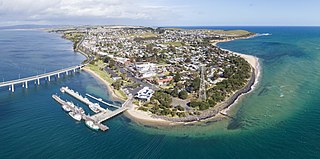
San Remo is a town in southern Victoria, Australia in the Gippsland region. Formed as a fishing village, its economy is now largely based on tourism. It is also notable as the town on the mainland end of the Phillip Island Bridge to Phillip Island. At the 2016 census, San Remo had a population of 1212.

Central Murchison was an electoral district of the Legislative Assembly in the Australian state of Western Australia from 1897 to 1901.

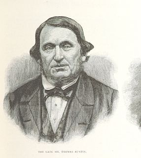
Thomas Austin was an English settler in Australia who is generally noted for the introduction of rabbits into Australia in 1859, even though rabbits had been brought previously to Australia by the First Fleet.
Wokalup is a town located in the South West region of Western Australia along the South Western Highway, between Harvey and Brunswick Junction. At the 2006 census, Wokalup had a population of 449.

Tolmie is a small rural town in central Victoria, Australia. It is located 22 kilometres (14 mi) north-east of Mansfield in the Victorian high country. At the 2011 census, Tolmie had a population of 547.

The Shire of Cue is a local government area in the Mid West region of Western Australia, about 420 kilometres (260 mi) east-northeast of the port city of Geraldton and about 650 kilometres (400 mi) north-northeast of the state capital, Perth. The Shire covers an area of 13,623 square kilometres (5,260 sq mi), and its seat of government is the town of Cue.

The geography of Australia encompasses a wide variety of biogeographic regions being the world's smallest continent, while comprising the territory of the sixth-largest country in the world. The population of Australia is concentrated along the eastern and south-eastern coasts. The geography of the continent is extremely diverse, ranging from the snow-capped mountains of the Australian Alps and Tasmania to large deserts, tropical and temperate forests, grasslands, heathlands and woodlands.
The Goldfields region of Western Australia has an extensive array of active and historical mining operations and towns.

Austin is an abandoned town in the Murchison region of Western Australia. The town is located south of Cue on an island in Lake Austin and for this reason was also known as Lake Austin and The Island Lake Austin.

Witchcliffe is a small town in the South West region of Western Australia, located a few kilometres south of Margaret River on the Bussell Highway. The name originates from a cave in the area, Witchcliffe cave, that was recorded by a surveyor in 1900. It is believed the name was given by the Bussell family whose property, Wallcliffe, was established in the area in the 1850s.

Cue was an electoral district of the Legislative Assembly in the Australian state of Western Australia from 1901 to 1930.

Mount William is a mountain of the Grampians Mountain Range, located within the Grampians National Park, in the Australian state of Victoria. The mountain is situated approximately 250 kilometres (160 mi) west-northwest of Melbourne on the eastern edge of the national park, approximately 22 kilometres (14 mi) drive from Halls Gap.

Wilga is a small town located between Donnybrook and Boyup Brook in the South West region of Western Australia.
Ninox boobook ocellata is a subspecies of the Australian boobook, which is also widely known as the southern boobook. The southern boobook is the most common and smallest owl on the Australian mainland.

Mainland Australia is the main landmass of the Australian continent, excluding Tasmania and other offshore islands. The landmass also constitutes the mainland of the territory governed by the Commonwealth of Australia, and the term, along with continental Australia, can be used in a geographic sense to exclude surrounding continental islands and external territories. Generally, the term is applied to the states of New South Wales, Queensland, South Australia, Victoria, and Western Australia, as well as the Australian Capital Territory, Jervis Bay Territory, and Northern Territory.
The Yawijibaya, also written Jaudjibaia, are an Aboriginal Australian people of the Kimberley region of northern Western Australia. Along with the Unggarranggu people, they are the traditional owners of Buccaneer Archipelago, off Derby, together known as the Mayala group for native title purposes. Yawijibaya country includes Montgomery Island (Yawajaba) and the surrounding Montgomery Reef.


