
Hillston is a township in western New South Wales, Australia, in Carrathool Shire, on the banks of the Lachlan River. It was founded in 1863 and at the 2016 census had a population of 1,465.

Cue is a small town in the Mid West region of Western Australia, located 620 km north-east of Perth. At the 2016 census, Cue had a population of 178. Cue is administered through the Cue Shire Council, which has its chambers in the historic Gentlemans Club building. The current president is Ross Pigdon. The Cue Parliament is held twice yearly in May and November.

Newman, originally named Mount Newman until 1981, is a town in the Pilbara region of Western Australia. It is located about 1,186 kilometres (737 mi) north of Perth, and 9 kilometres (5.6 mi) north of the Tropic of Capricorn. It can be reached by the Great Northern Highway. Newman is a modern mining town, with homes contrasting with the surrounding reddish desert. The Hickman Crater is 35 kilometres (22 mi) north of Newman.

The Murchison River is the second longest river in Western Australia. It flows for about 820 km (510 mi) from the southern edge of the Robinson Ranges to the Indian Ocean at Kalbarri. The Murchison-Yalgar-Hope river system is the longest river system in Western Australia. It has a mean annual flow of 208 gigalitres, although in 2006, the peak year on record since 1967, flow was 1,806 gigalitres.
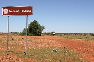
Nannine is a ghost town in the Mid West region of Western Australia. It is located on the northern bank of Lake Anneen, approximately 35 kilometres (22 mi) south-southwest of Meekatharra, and 735 kilometres (457 mi) north-northeast of Perth.
Kambalda is a small mining town about 60 kilometres (37 mi) from the mining city of Kalgoorlie in Western Australia, within the Goldfields. It is split into two townsites 4 kilometres (2.5 mi) apart, Kambalda East and Kambalda West; and is located on the western edge of a giant salt lake, Lake Lefroy. At the last census, Kambalda had a combined population of 2,468.

Kukerin is a small town in the Wheatbelt region of Western Australia, 302 kilometres (188 mi) south-east of Perth between Dumbleyung and Lake Grace just off Dumbleyung Lake Grace Road on State Route 107. The town itself is small but services a considerable agricultural region in the eastern Shire of Dumbleyung. At the 2021 census, Kukerin and its surrounding areas had a population of 55.

The Shire of Cue is a local government area in the Mid West region of Western Australia, about 420 kilometres (260 mi) east-northeast of the port city of Geraldton and about 650 kilometres (400 mi) north-northeast of the state capital, Perth. The Shire covers an area of 13,623 square kilometres (5,260 sq mi), and its seat of government is the town of Cue.

The Shire of Meekatharra is a local government area in the Mid West region of Western Australia, about halfway between the town of Port Hedland and the state capital, Perth, Western Australia. The Shire covers an area of 100,789 square kilometres (38,915 sq mi), and its seat of government is the town of Meekatharra.

Sandstone is a small town in the Mid West region of Western Australia 157 kilometres (98 mi) east of Mount Magnet and 661 kilometres (411 mi) north of the state capital, Perth. At the 2016 census, Sandstone and the surrounding Shire of Sandstone a population of 89 people, including 19 families. Sandstone is the administrative centre and only town in the Shire of Sandstone local government area.
Abbotts is an abandoned town in Western Australia located in the Murchison Goldfields region of Western Australia located 31 km (19 mi) north-west of Meekatharra on the Meekatharra – Mount Clere Road.
Gabanintha is a ghost town located in the Mid West region of Western Australia approximately 40 km south east of Meekatharra on the Meekatharra-Sandstone road. The town is situated within the Murchison goldfields.
Bulong is an abandoned town in Western Australia located 580 kilometres (360 mi) east of Perth in the Goldfields-Esperance region of Western Australia.
Bardoc is an abandoned town in the Goldfields-Esperance region of Western Australia. It is situated between Kalgoorlie and Menzies along the Goldfields Highway.
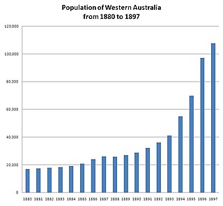
In the latter part of the nineteenth century, discoveries of gold at a number of locations in Western Australia caused large influxes of prospectors from overseas and interstate, and classic gold rushes. Significant finds included:
Cuddingwarra is an abandoned town in the Mid West region of Western Australia. The town is located between Cue and Big Bell.
Annean Station is a pastoral lease in Western Australia.

Stirling Terrace, Albany is a street in the centre of Albany, Western Australia adjoining York Street.
The Nannine Road District was an early form of local government area on the Western Australian goldfields of the Mid West region.
The Municipality of Nannine was a local government area in Western Australia, centred on the mining town of Nannine.
