The Drakensberg is the eastern portion of the Great Escarpment, which encloses the central Southern African plateau. The Great Escarpment reaches its greatest elevation – 2,000 to 3,482 metres within the border region of South Africa and Lesotho.

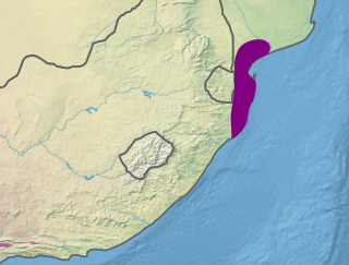
The Kwazulu-Cape coastal forest mosaic is a subtropical moist broadleaf forest ecoregion of South Africa. It covers an area of 17,800 square kilometers (6,900 sq mi) in South Africa's Eastern Cape and KwaZulu-Natal provinces.
The Maputaland coastal forest mosaic is a subtropical moist broadleaf forest ecoregion on the Indian Ocean coast of Southern Africa. It covers an area of 29,961 square kilometres (11,568 sq mi) in southern Mozambique, Eswatini, and the KwaZulu-Natal Province of South Africa. Mozambique's capital Maputo lies within the ecoregion.

The Cape Floral Region is a floristic region located near the southern tip of South Africa. It is the only floristic region of the Cape Floristic Kingdom, and includes only one floristic province, known as the Cape Floristic Province.

The Coastal forests of eastern Africa, also known as the East African Coastal Forests or Zanzibar–Inhambane forests, is a tropical moist forest region along the east coast of Africa. The region was designated a biodiversity hotspot by Conservation International.

Pondoland or Mpondoland, is a natural region on the South African shores of the Indian Ocean. It is located in the coastal belt of the Eastern Cape province. Its territory is the former Mpondo Kingdom of the Mpondo people.

The Wild Coast is a section of the coast of the Eastern Cape, a province of South Africa. The region stretches from East London in the south to the border of KwaZulu-Natal in the north. It is the traditional home of the Mpondo people, and the birthplace of many prominent South Africans, including Nelson Mandela and Thabo Mbeki.

Mkhambathi Nature Reserve is a protected area at Lusikisiki in the Eastern Cape, South Africa. It is 7,720 hectares, with the Pondoland Marine Protected Area off its coastal edge. The reserve is located in the Pondoland Centre of Plant Endemism and the greater Maputaland–Pondoland–Albany Hotspot, and is covered in open grassland, dotted with patches of indigenous forest, swamp forests and flanked by the forested ravines of the Msikaba and Mtentu rivers.
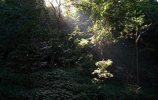
Areas of forest which grow in KwaZulu-Natal, South Africa mostly on south facing slopes in higher rainfall areas, and along the humid coastal areas. Different types of forest can be identified by their species composition which depends mostly on the altitude, latitude and substrate in which they grow. South facing slopes are favourable for the development of forest as they are more shaded, and therefore cooler and retain more moisture than the northern slopes. The extra moisture on the south slopes is not only favoured by forest trees, but also helps to prevent or subdue wildfires. Fires can also be blocked by cliff faces and rocks or boulders on these slopes, and by streams or rivers at the base of the slopes. The coastal regions are conducive to forest formation, because of high rainfall and humidity which are favoured by forest trees and also help to prevent or subdue fires. The rivers of the coastal areas are also broader than further inland, which may often prevent fires from spreading long distances, and fires generally burn uphill and therefore more often away from areas at low altitude.
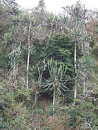
The Pondoland Centre of Plant Endemism is situated in the coastal region overlapping the provinces of KwaZulu-Natal and the Eastern Cape in South Africa. It is named after Pondoland and falls within the Maputaland-Pondoland-Albany Hotspot. The region consists of grassy plateaus incised by forested ravines and gorges. The main substrate in the area is Natal Group Sandstone, which was formed by sediments laid down about 500 million years ago in a rift underlying the eastern Agulhas Sea in the ancient continent of Gondwana. The region is about 18,800 hectares in extent, and lies along the coastline stretching about 15 kilometres inland with a maximum altitude of about 400 to 500 metres above sea level. The region is essentially a transition zone between sub-tropical and temperate climates.

The Maputaland-Pondoland-Albany Hotspot (MPA) is a biodiversity hotspot, a biogeographic region with significant levels of biodiversity, in Southern Africa. It is situated near the south-eastern coast of Africa, occupying an area between the Great Escarpment and the Indian Ocean. The area is named after Maputaland, Pondoland and Albany. It stretches from the Albany Centre of Plant Endemism in the Eastern Cape Province of South Africa, through the Pondoland Centre of Plant Endemism and KwaZulu-Natal Province, the eastern side of Eswatini and into southern Mozambique and Mpumalanga. The Maputaland Centre of Plant Endemism is contained in northern KwaZulu-Natal and southern Mozambique.

Maputaland is a natural region of Southern Africa. It is located in the northern part of the province of KwaZulu-Natal, South Africa between Eswatini and the coast. In a wider sense it may also include the southernmost region of Mozambique. The bird routes and coral reefs off the coast are major tourist attractions.
The Albany Centre of Plant Endemism is situated in the coastal region of South Africa at the eastern end of the Eastern Cape Province. It is named after the district of Albany and falls within the Maputaland-Pondoland-Albany Hotspot. It is notable for its biodiversity and unique, endemic flora and fauna.
The Maputaland Centre of Plant Endemism is situated in the coastal region of South Africa in the northern part of the province of KwaZulu-Natal, and also includes the southernmost part of Mozambique. It forms part of the Maputaland-Pondoland-Albany Hotspot. It is notable for its biodiversity and unique, endemic flora and fauna.

The Somali Acacia–Commiphora bushlands and thickets is a semi-arid tropical grasslands, savannas, and shrublands ecoregion in the Horn of Africa. It is home to diverse communities of plants and animals, including several endemic species.
The Indian Ocean coastal belt is one of the nine recognised biomes of South Africa. They are described in terms of their vegetation and climatic variations.
The Biodiversity of South Africa is the variety of living organisms within the boundaries of South Africa and its exclusive economic zone. South Africa is a region of high biodiversity in the terrestrial and marine realms. The country is ranked sixth out of the world's seventeen megadiverse countries, and is rated among the top 10 for plant species diversity and third for marine endemism.