The Federal Capital Territory (FCT), is a federal territory in central Nigeria. Abuja, the capital city of Nigeria, is located in this territory. The FCT was formed in 1976 from parts of the states of old Kaduna, Kwara, Niger, and Plateau states, with the bulk of land mass carved out of Niger state. The Federal Capital Territory is within the North Central region of the country. Unlike other states of Nigeria, which are headed by elected Governors, it is administered by the Federal Capital Territory Administration, headed by a minister, who is appointed by the President.

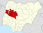
Niger is a state in the North Central region of Nigeria and the largest state in the country. Niger state has three political zones, zone A, B and C. The state's capital is at Minna. Other major cities are Bida, Kontagora and Suleja. It was formed in 1976 when the then North-Western State was divided into Niger State and Sokoto State. It is home to Ibrahim Babangida and Abdulsalami Abubakar, two of Nigeria's former military rulers. The Nupe, Gbagyi, Kamuku, Kambari, Gungawa, Hun-Saare, Hausa and Koro form the majority of numerous indigenous tribes of Niger State.

Kano State is one of the 36 states of Nigeria, located in the northern region of the country. According to the national census done in 2006, Kano State is the most populous in Nigeria. The recent official estimates taken in 2016 by the National Bureau of Statistics found that Kano State was still the largest state by population in Nigeria. Created in 1967 out of the former Northern Region, Kano State borders Katsina State to the northwest, Jigawa State to the northeast, Bauchi State to the southeast, and Kaduna State to the southwest. The state's capital and largest city is the city of Kano, the second most populous city in Nigeria after Lagos. The incumbent governor of the state is Abba Kabir Yusuf. He was sworn in on 29 May 2023.

Jigawa State (Hausa: Jihar Jigawa is one of the 36 states of Nigeria, located in the northern region of the country. Created on August 27, 1991, under the General Ibrahim Babangida who announced the creation of nine additional states in the country bringing the total number of states then to thirty. The announcement was given a legal backing through the; State Creation and Transitional Provisions Decree No. 37 of 1991. Jigawa State is located in the northeastern-most region of Kano State, and shares border with Nigeria's national border with the Republic of the Niger. The state capital and largest city is Dutse. Jigawa state has 27 local governments

Kebbi State is a state in the northwestern Nigeria, Kebbi State is bordered east and north of Sokoto and Zamfara states, and to the south by Niger state while its western border forms part of the national borders with Benin Republic and Niger. Named for the city of Birnin Kebbi—the state's capital and largest city, Kebbi state was formed from Sokoto state on 27 August 1991. Of the 36 states of Nigeria, Kebbi is the tenth largest in area and 22nd most populous, with an estimated population of about 4.4 million as of 2016. The state is known as land of equity.

Kwara State, is a state in Western Nigeria, bordered to the east by Kogi State, to the north by Niger state, and to the south by Ekiti, Osun, and Oyo states, while its western border makes up part of the international border with Benin Republic. Its capital is the city of Ilorin and the state has 16 local government areas.

SokotoState is one of the 36 states of Nigeria, located in the extreme northwest of the country on the national border with the Republic of the Niger. Its capital and largest city is the city of Sokoto. Sokoto is located near to the confluence of the Sokoto River and the Rima River. As of 2005 it has an estimated population of more than 4.2 million.
Zamfara is a state in northwestern Nigeria. The capital of Zamfara state is Gusau and its current Governor is Dauda Lawal. Until 1996, the area was part of Sokoto State.
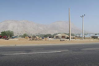
Yelwa is a town in Kebbi State, Nigeria on the Niger River and the A1 highway. The town is often referred to as "Yelwa, Yauri", after the Emirate and Local Government Administration it is in, and is not the Yelwa where the Yelwa Massacre took place in 2004 in Plateau State. Yelwa is the capital and largest city of the Yauri Emirate. Yelwa has a population of 8,000 as of 2010, a majority of whom are Hausa Muslims.
Busa, or Bisã, is the Mande language of the former Borgu Emirate in northwestern Nigeria and northern Benin. It is called Busanci in Hausa, and has also been called Zugweya.
Cipu (Cicipu), or Western Acipa, is a Kainji language spoken by about 20,000 people in northwest Nigeria. The people call themselves Acipu, and are called Acipawa in Hausa.
Gwandara is a West Chadic language, and the closest relative of Hausa. Its several dialects are spoken in northern Nigeria, predominantly in the north central region of Nigeria by the Gwandara people and some settlers who are about 30,000 people. They are found in large numbers in Abuja, Niger, Kaduna, Kogi and a resettlement town of New Karshi, Karu LGA, Nasarawa State. New Karshi has a Gwandara first class emir Muhammadu Bako III (PhD).

Kaiama is a Local Government Area and town in northwestern Kwara State, Nigeria. Its headquarters are in the town of Kaiama.
Bagudo is a Local Government Area in Kebbi State, Nigeria, sharing a boundary with the Republic of Niger and Republic of Benin. Its headquarters are in the town of Bagudo.
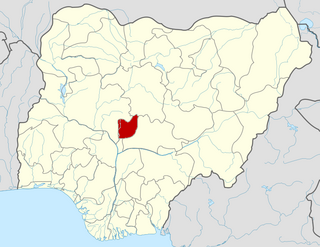
Rafi is a Local Government Area in Niger State, Nigeria. Its headquarters are in the town of Kagara on the A125 highway. The southern border of the area is the Kaduna River. Towns in the LGA include Tegina, and Pandogari
The Borgu Local Government Area is an administrative region in Niger State, Nigeria, It is one of the 25 Local Government Areas (LGAs) in the state, with the headquarter situated in the town of New Bussa. The postal code is 913. The Borgu LGA was formerly part of Kwara State, but on 27 August 1991 it was transferred to Niger State.
The Kamuku languages are a branch of the Kainji languages spoken by the Kamuku people of Niger State, western Nigeria, mostly in Mariga and Rafi LGAs.
The Cinda-Regi language is a language complex of Nigeria belonging to the Kamuku branch of Kainji languages.
The Kimba languages (Tsikimba; or the Kambari II languages) are a group of Kainji languages of Nigeria spoken by the Kambari people. The languages are Kimba (Tsikimba), Gaushi (Agaushi), and Wenci (Ngwunci).
Rogo is a Kainji language of Nigeria. It is spoken around the town of Ucanja in the Rafi and Mariga Local Government Areas of Niger State, as well as the Birnin Gwari LGA of neighbouring Kaduna State.