Tafa

Last updated

Tafa
LGA
Nigeria location map.svg
Red pog.svg
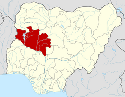
Tafa
Location in Nigeria
Coordinates: 9°15′N7°15′E / 9.250°N 7.250°E / 9.250; 7.250
CountryFlag of Nigeria.svg  Nigeria
State Niger State
Government
  Local Government ChairmanHon Danladi T Iyah(APC)
Area
  Total222 km2 (86 sq mi)
Population
 (2006 census)
  Total83,544
Time zone UTC+1 (WAT)
3-digit postal code prefix
910
ISO 3166 code NG.NI.TA
Tafa

Tafa is a Local Government Area in Niger State, Nigeria, adjoining the Federal Capital Territory. Its headquarters is in the town of Wuse.

Contents

It has an area of 222 km2 and a population of 83,544 at the 2006 census.

The postal code of the area is 910. [1]

Climate/Geographic

Tafa Local Governments Area covers an area of 222 square kilometers and experiences average temperatures of 31 °C. The average humidity in the LGA is 30%, and the annual total amount of precipitation there is estimated to be 1650 mm. [2] [3] [4]

Tafa, which at 224.42 meters 736.29 feet above sea level, has a climate classified as subtropical steppe (BSh). The district's annual temperature is 33.42 oC 92.16 oF, which is 1.38% warmer than the national average for Niger. Tafa experiences 33.26 wet days 9.11% per year and averages 19.84 millimeters 0.78 inches of precipitation yearly. [5] [6]

Economy

The Tafa Local Governments Area's economy heavily relies on trade, and the region is home to a number of marketplaces, including the Gauraka market where a variety of items are bought and sold.  In addition to farming, raising animals, hunting, manufacturing ceramics, crafts, and wood carving, Tafa Local Governments Area residents also engage in other significant economic activities.

Related Research Articles

<span class="mw-page-title-main">Umuahia</span> Capital city of Abia State, Nigeria

Umuahia is the capital city of Abia State in southeastern Nigeria. Umuahia is located along the rail road that lies between Port Harcourt to its south,and Enugu city to its north. Umuahia has a population of 359,230 according to the 2006 Nigerian census. Umuahia is indigenously Igbo.

Yenagoa is a Local Government Area and capital city of Bayelsa State, southern Nigeria. It is located at the southern part of the country at coordinates 4°55′29″N6°15′51″E.

<span class="mw-page-title-main">Gboko</span> Place in Benue State, Nigeria

Gboko is a Local Governments Area is in Benue state. North-central Nigeria. Its headquarters in the town of Gboko.

Batagarawa is a Local Government Area in Katsina State, Nigeria. Its headquarters are in the town of Batagarawa.

Bende is a Local Government Area in Abia State, Nigeria with headquarters located in Bende Community. Bende Local Government Area (L.G.A) of Abia state lies on 70 30I of the Greenwich Meridian and latitude 50 30I North of the Equator. It is composed of thirteen (13) communities, namely: Alayi, Bende, Ezukwu, Igbere, Item, Itumbuzo, Nkpa, Ntalakwu, Ozuitem, Ugwueke, Umu-imenyi, Umuhu-Ezechi, and Uzuakoli.

Kaura Namoda is a Local Government Area in Zamfara State, Nigeria. Its headquarters are in the town of Kaura-Namoda, home to the Federal Polytechnic, Kaura-Namoda. It has an area of 868 km2 and a population of 281,367 at the 2006 census.

Kaltungo is one among the 11 Local Governments Area of Gombe State, Nigeria. Its headquarters is in the town of Kaltungo in the western part of the Local Government Area on the A345 highway at 9°48′51″N11°18′32″E.

Yamaltu/Deba is a Local Government Area of Gombe State, Nigeria. Its headquarters is in the town of Deba, at the southeastern part of the state capital, Gombe.

Owerri West is a Local Government Area of Imo State, Nigeria. Its headquarters are in the town of Umuguma. Owerri West Local Government is administered under the terms of the Constitution of the Federal Republic of Nigeria. Elections to the office of the Chairman of the local government are held through nominations by registered political parties as stipulated by the constitution of the Federal Republic of Nigeria, under the supervision of Imo State Electoral Commission. Owerri West was carved out of the former Owerri Local Government Area in 1996. A very large portion of the local government constitute the capital city of Imo State, Nigeria.

Baure is a Local Government Area in Katsina State, Nigeria, sharing a border with the Republic of Niger. Its headquarters are in the town of Baure in the northwest of the area at 12°50′10″N8°44′47″E.

Musawa is a Local Government Area in Katsina State, Nigeria. Its headquarters are in the town of Musawa.

Birnin Gwari is a Local Government Area in Kaduna State, Nigeria. Its headquarters are in the town of Birnin Gwari.

Kagarko is a Local Government Area in southern Kaduna State of Nigeria. Its headquarters are in the town of Kagarko. It has an area of 2,356 km2 and a population of 239,058 at the 2006 census. The Local Government Council is chaired by Nasara Rabo. The postal code is 802.

<span class="mw-page-title-main">Keffi</span> LGA and Town in Nasarawa State, Nigeria

Keffi Local Government Area and also is a traditional or commercial town in Nasarawa north central nigeria Its headquarters are in the town of Keffi. Keffi is 50 kilometers from Abuja. Nasarawa State university is located in Keffi sitting along Keffi-Akwanga express way.

<span class="mw-page-title-main">Bosso, Nigeria</span> LGA in Niger State, Nigeria

Bosso is a Local Government Area in Niger State, Nigeria. Its headquarters are in the town of Maikunkele.

Wushishi is a Local Government Area in Niger State, Nigeria. Its headquarters is in the town of Wushishi.

Nangere is a Local Government Area in Yobe State, Nigeria. It has its headquarters in the town of Sabon Garin Nangere.

Yusufari is a Local Government Area in Yobe State, Nigeria. Its headquarters are in the town of Yusufari in the south-east of the area at 13°04′06″N11°10′33″E. It shares a border in the north with The Republic of Niger.

Sabon Birni is a Local Government Area in Sokoto State, Nigeria. Its headquarters are in the town of Sabon Birni.

Illela is a Local Government Area in Sokoto State, Nigeria. Its headquarters are in the town of Illela.

References

  1. "Post Offices- with map of LGA". NIPOST. Archived from the original on 2009-10-07. Retrieved 2009-10-20.
  2. "Tafa Local Government Area". www.manpower.com.ng. Retrieved 2023-09-25.
  3. "Tafa, Nigeria Weather Conditions | Weather Underground". www.wunderground.com. Retrieved 2023-09-25.
  4. "Tafa weather and climate ☀️ Best time to visit 🌡️ Temperature". www.besttimetovisit.co.nz. Retrieved 2023-09-25.
  5. "Tafa Kouara, Niamey, NE Climate Zone, Monthly Averages, Historical Weather Data". tcktcktck.org. Retrieved 2023-09-25.
  6. "Tafa weather forecast for today". justweather.org. Retrieved 2023-09-25.