Mars Exploration Ice Mapper

Last updated

International-Mars Ice Mapper
INTERNATIONAL MARS ICE MAPPER.jpg
This illustration depicts four orbiters as part of the International-Mars Ice Mapper (I-MIM) mission concept. At lower left, an orbiter passes above the Martian surface, detecting buried water ice through a radar instrument and large reflector antenna. Circling Mars at a higher altitude are three telecommunications orbiters, with one shown relaying data back to Earth. [1]
NamesI-MIM
Mars Exploration Ice Mapper
Mission type Mars orbiter
Operator NASA / JAXA / CSA / ASI
Mission duration2 years (planned)
Start of mission
Launch date2026
Launch site Cape Canaveral
Orbital parameters
Reference system Areocentric orbit
Regime Circular orbit
Periareon altitude 250–320 km (160–200 mi)
Apoareon altitude 250–320 km (160–200 mi)
Inclination 74.0°
Period 110.0 minutes
  MAVEN
 

The International-Mars Ice Mapper (I-MIM) mission is a proposed Mars orbiter being developed by NASA in collaboration with the Japan Aerospace Exploration Agency (JAXA), the Canadian Space Agency (CSA), and the Italian Space Agency (ASI). [2] As the mission concept evolves, there may be opportunities for other space agency and commercial partners to join the mission. [1] The goal of the orbiter is the quantification of extent and volume of water ice in non-polar regions of Mars. The results are intended to support future Mars missions, especially with respect to the search for habitable environments and accessible In situ resource utilization (ISRU) resources. The International-Mars Ice Mapper is an "exploration precursor mission", comparing it to the Lunar Reconnaissance Orbiter (LRO) mission. [2] The mission was envisioned to be launched as early as 2026. [1] [3] However, in March 2022, it was revealed in its fiscal year 2023 budget proposal that the US government would terminate NASA financial support for the Mars Ice Mapper, [4] casting the project's future into uncertainty.

Contents

Mission

The mission is to search for ice deposits under the surface of Mars, precursor for human missions there. By identifying locations where water ice may exist within 5-10 meters of the surface and thus could be accessed by crewed expeditions. [2] The mission plans to scan specific locations on the Martian surface below 2 km (1.2 mi) elevation (to enable entry, descent and landing). The target areas for radar scans are between 25° and 40° northern latitude and 25° and 40° southern latitude. The upper limit of 40° was chosen to have favorable conditions for solar arrays. The lower bound of 25° is intended to maximize the proximity of locating ground ice (since availability of ground ice generally decreases toward the equator due to increased insolation). [3]

The ice-mapping mission could help the agency identify potential science objectives for initial human missions to Mars, which are expected to be designed for about 30 days of exploration on the surface. For example, identifying and characterizing accessible water ice could lead to human-tended science, such as ice coring to support the search for life. Mars Ice Mapper also could provide a map of water-ice resources for later human missions with longer surface expeditions, as well as help meet exploration engineering constraints, such as avoidance of rock and terrain hazards. Mapping shallow water ice could also support supplemental high-value science objectives related to Martian climatology and geology. [1]

Science

Beyond promoting scientific observations while the orbiter completes its reconnaissance work, the agency partners will explore mission-enabling rideshare opportunities as part of their next phase of study. All science data from the mission would be made available to the international science community for both planetary science and Mars reconnaissance. This approach is similar to what NASA is doing at the Moon under the Artemis program – sending astronauts to lunar South Pole, where ice is trapped in the permanently shadowed regions of the pole. [1]

Access to water ice would also be central to scientific investigations on the surface of Mars that are led by future human explorers. Such explorers may one day core, sample, and analyze the ice to better understand the record of climatic and geologic change on Mars and its astrobiological potential, which could be revealed through signs of preserved ancient microbial life or even the possibility of living organisms, if Mars ever harbored life. Ice is also a critical natural resource that could eventually supply hydrogen and oxygen for fuel. These elements could also provide resources for backup life support, civil engineering, mining, manufacturing, and, eventually, agriculture on Mars. Transporting water from Earth to deep space is extremely costly, so a local resource is essential to sustainable surface exploration. [1]

"In addition to supporting plans for future human missions to Mars, learning more about subsurface ice will bring significant opportunities for scientific discovery", said Eric Ianson, NASA Planetary Science Division Deputy Director and Mars Exploration Program Director. "Mapping near-surface water ice would reveal an as-yet hidden part of the Martian hydrosphere and the layering above it, which can help uncover the history of environmental change on Mars and lead to our ability to answer fundamental questions about whether Mars was ever home to microbial life or still might be today". [1]

Mars has been a primary target for robotic exploration and the search for ancient life in our Solar System. Mars Ice Mapper would complement surface missions on the planet, including the Perseverance rover that landed on February 18, 2021, following a seven-month journey in space. NASA and the European Space Agency (ESA) also recently announced they are moving forward with the Mars sample-return mission. [1]

Spacecraft

The CSA would provide the radar instrument, JAXA the spacecraft bus and ASI the communications subsystem for the spacecraft. NASA would be responsible for overall mission management and for providing the launch of the spacecraft. The mission will cost US$185 million. [2]

NASA included an illustration of Mars Ice Mapper communicating with three spacecraft in Mars orbit, acting as communications relays back to Earth. The agency has previously discussed developing a communications satellite network at Mars, perhaps through public-private partnerships, to support Mars Ice Mapper. [2]

Instrument

The mission concept plans to utilize Synthetic-aperture radar, based on technology used by the Canadian RADARSAT satellite constellation. [3]

The radar has the following technical specification: [3]

See also

Related Research Articles

<i>2001 Mars Odyssey</i> 2001 NASA orbiter studying the geology and hydrology of Mars

2001 Mars Odyssey is a robotic spacecraft orbiting the planet Mars. The project was developed by NASA, and contracted out to Lockheed Martin, with an expected cost for the entire mission of US$297 million. Its mission is to use spectrometers and a thermal imager to detect evidence of past or present water and ice, as well as study the planet's geology and radiation environment. It is hoped that the data Odyssey obtains will help answer the question of whether life existed on Mars and create a risk-assessment of the radiation that future astronauts on Mars might experience. It also acts as a relay for communications between the Curiosity rover, and previously the Mars Exploration Rovers and Phoenix lander, to Earth. The mission was named as a tribute to Arthur C. Clarke, evoking the name of his and Stanley Kubrick's 1968 film 2001: A Space Odyssey.

Phobos (moon) Larger, inner moon of Mars

Phobos is the innermost and larger of the two natural satellites of Mars, the other being Deimos. Both moons were discovered in 1877 by American astronomer Asaph Hall. Phobos is named after the Greek god Phobos, a son of Ares (Mars) and Aphrodite (Venus) and twin brother of Deimos. Phobos was the god and personification of fear and panic.

<i>Mars Express</i> European Mars orbiter

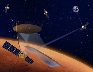
Mars Express is a space exploration mission being conducted by the European Space Agency (ESA). The Mars Express mission is exploring the planet Mars, and is the first planetary mission attempted by the agency. "Express" originally referred to the speed and efficiency with which the spacecraft was designed and built. However, "Express" also describes the spacecraft's relatively short interplanetary voyage, a result of being launched when the orbits of Earth and Mars brought them closer than they had been in about 60,000 years.

Exploration of Mars Overview of the exploration of Mars

The planet Mars has been explored remotely by spacecraft. Probes sent from Earth, beginning in the late 20th century, have yielded a large increase in knowledge about the Martian system, focused primarily on understanding its geology and habitability potential. Engineering interplanetary journeys is complicated and the exploration of Mars has experienced a high failure rate, especially the early attempts. Roughly sixty percent of all spacecraft destined for Mars failed before completing their missions and some failed before their observations could begin. Some missions have met with unexpected success, such as the twin Mars Exploration Rovers, Spirit and Opportunity which operated for years beyond their specification.

<i>Mars Reconnaissance Orbiter</i> NASA Mars orbiter launched in 2005, still operational

Mars Reconnaissance Orbiter (MRO) is a spacecraft designed to study the geology and climate of Mars, provide reconnaissance of future landing sites, and relay data from surface missions back to Earth. It was launched on August 12, 2005 and reached Mars on March 10, 2006. In November 2006, after five months of aerobraking, it entered its final science orbit and began its primary science phase. The cost to develop and operate MRO through the end of its prime mission in 2010 was US$716.6 million.

The Lunar Precursor Robotic Program (LPRP) is a NASA program that uses robotic spacecraft to prepare for future manned missions to the Moon. The program gathers data such as lunar radiation, surface imaging, areas of scientific interest, temperature and lighting conditions, and potential resource identification.

MARSIS

MARSIS is a low frequency, pulse-limited radar sounder and altimeter developed by the University of Rome La Sapienza and Alenia Spazio. The Italian MARSIS instrument is operational on the European Space Agency, Mars Express orbiter mission.

Outline of space exploration Overview of and topical guide to space exploration

The following outline is provided as an overview of and topical guide to space exploration.

Lunar Reconnaissance Orbiter NASA robotic spacecraft orbiting the Moon

The Lunar Reconnaissance Orbiter (LRO) is a NASA robotic spacecraft currently orbiting the Moon in an eccentric polar mapping orbit. Data collected by LRO have been described as essential for planning NASA's future human and robotic missions to the Moon. Its detailed mapping program is identifying safe landing sites, locating potential resources on the Moon, characterizing the radiation environment, and demonstrating new technologies.

Trace Gas Orbiter Mars orbiter, part of ExoMars programme

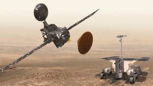
The ExoMars Trace Gas Orbiter is a collaborative project between the European Space Agency (ESA) and the Russian Roscosmos agency that sent an atmospheric research orbiter and the Schiaparelli demonstration lander to Mars in 2016 as part of the European-led ExoMars programme.

Northern Light (spacecraft) Cancelled Canadian Mars lander and rover mission

Northern Light was a concept mission for a robotic mission to Mars that would consist of a lander and a rover, being studied by a consortium of Canadian universities, companies and organisations. The primary contractor for the spacecraft was Thoth Technology Inc.

Mars Exploration Program Uncrewed spaceflight program by NASA focused on scientific exploration of Mars using orbiters, landers, and rovers

Mars Exploration Program (MEP) is a long-term effort to explore the planet Mars, funded and led by NASA. Formed in 1993, MEP has made use of orbital spacecraft, landers, and Mars rovers to explore the possibilities of life on Mars, as well as the planet's climate and natural resources. The program is managed by NASA's Science Mission Directorate by Doug McCuistion of the Planetary Science Division. As a result of 40% cuts to NASA's budget for fiscal year 2013, the Mars Program Planning Group (MPPG) was formed to help reformulate the MEP, bringing together leaders of NASA's technology, science, human operations, and science missions.

Phobos And Deimos & Mars Environment NASA Mars orbiter mission concept

Phobos And Deimos & Mars Environment (PADME) is a low-cost NASA Mars orbiter mission concept that would address longstanding unknowns about Mars' two moons Phobos and Deimos and their environment.

Lunar Flashlight Planned lunar orbiter by NASA

The Lunar Flashlight is a planned low-cost CubeSat lunar orbiter mission to explore, locate, and estimate size and composition of water ice deposits on the Moon for future exploitation by robots or humans.

Lunar IceCube Nanosatellite

Lunar IceCube is a planned NASA nanosatellite orbiter mission to prospect, locate, and estimate amount and composition of water ice deposits on the Moon for future exploitation by robots or humans. It will fly as a secondary payload mission on Artemis 1, the first flight of the Space Launch System (SLS), planned to launch in 2022.

Tianwen-1 Interplanetary mission by China to place an orbiter, lander and rover on Mars

Tianwen-1 is an interplanetary mission by the China National Space Administration (CNSA) which sent a robotic spacecraft to Mars, consisting of 6 spacecrafts: an orbiter, two deployable cameras, lander, remote camera, and the Zhurong rover. The spacecraft, with a total mass of nearly five tons, is one of the heaviest probes launched to Mars and carries 14 scientific instruments. It is the first in a series of planned missions undertaken by CNSA as part of its Planetary Exploration of China program.

The following outline is provided as an overview of and topical guide to Mars:
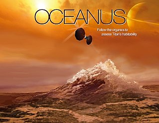
Martian Moons eXploration (MMX) Planned sample-return mission by Japan to Phobos

The Martian Moons eXploration (MMX) is a robotic space probe set for launch in 2024 to bring back the first samples from Mars' largest moon Phobos. Developed by the Japanese Aerospace Exploration Agency (JAXA) and announced on 9 June 2015, MMX will land and collect samples from Phobos once or twice, along with conducting Deimos flyby observations and monitoring Mars' climate.

The Fine-Resolution Epithermal Neutron Detector (FREND) is a neutron detector that is part of the instrument payload on board the Trace Gas Orbiter (TGO), launched to Mars in March 2016. This instrument is currently mapping hydrogen levels to a maximum depth of 1 m beneath the Martian surface, thus revealing shallow water ice distribution. This instrument has an improved resolution of 7.5 times over the one Russia contributed to NASA's 2001 Mars Odyssey orbiter.

References

  1. 1 2 3 4 5 6 7 8 "NASA, International Partners Assess Mission to Map Ice on Mars, Guide Science Priorities". NASA. 3 February 2021. Retrieved 7 February 2021.PD-icon.svgThis article incorporates text from this source, which is in the public domain .
  2. 1 2 3 4 5 "NASA and international partners to study Mars Ice Mapper mission". SpaceNews. 6 February 2021. Retrieved 7 February 2021.
  3. 1 2 3 4 "Mars Exploration Ice Mapper" (PDF). NASA. 15 April 2020.PD-icon.svgThis article incorporates text from this source, which is in the public domain .
  4. Foust, Jeff (28 March 2022). "White House requests $26 billion for NASA for 2023". spacenews.com. Retrieved 1 April 2022.