Marsh Gibbon and Poundon railway station

Last updated

Marsh Gibbon and Poundon
Marsh Gibbon and Poundon station (1967).JPG
Station in 1967.
General information
Location Marsh Gibbon, Buckinghamshire
England
Grid reference SP651246
Platforms2
Other information
StatusDisused
History
Original company LNWR
Pre-grouping LNWR
Post-grouping LMS
Key dates
7 August 1880Station opens
1 January 1968Station closes [1]

Marsh Gibbon and Poundon railway station was a railway station to the west of Verney Junction on the Oxford and Bletchley section of the LNWR's branch of what is now known as the Varsity Line.

Contents

History

The line was opened in 1850–51 with a station at Launton some two miles away. The original intention had been to call this station Poundon Bridge, however the name never seems to have been used. Marsh Gibbon and Poundon opened on 7 August 1880. [2]

The era of extravagantly designed and built country stations had long passed, and what was provided were simple but practical timber buildings without awnings. Oddly the station still retained the low platforms of earlier stations on the line. Even though there were proposals to raise them in the early 20th century, they remained until closure. Small moveable steps had to be provided to allow passengers to board and alight easily.

Station house in 2007. Marsh Gibbon & Poundon station house geograph-3784254-by-Ben-Brooksbank.jpg
Station house in 2007.

Another feature was the bay window in the main building which was on the down Oxford platform. This projected out onto the platform since it was the signal box. There was a clock in the centre which was visible on the platforms as required by the Board of Trade. There was a small waiting shed on the up Bletchley-bound platform, and a single siding off the down, running at an angle in front of the main building

At grouping in 1923 it became part of the London Midland and Scottish Railway; it duly passed to British Railways in 1948, as part of the London Midland Region. Diesel trains were provided for passenger services from 2 November 1959. [3] The station stopped handling goods traffic on 2 November 1964; the signalbox was closed in January 1965 [4] and passenger services were withdrawn when the whole of the route from Bletchley to Oxford closed on 1 January 1968. [3] . The station was demolished within a year after closure.

Routes

Preceding station Disused railways Following station
Launton
Line and station closed
  London and North Western Railway
Varsity Line
  Claydon
Line and station closed
Varsity Line
BSicon HUBrg-R.svg
BSicon HUB-Lq.svg
BSicon CONTg.svg
BSicon HUB-Lq.svg
Gnome-searchtool.svg
BSicon HUBlg-L.svg
Oxford
Rewley Road
BSicon HUB-R.svg
BSicon exKBHFa.svg
BSicon BHF.svg
BSicon HUB-L.svg
Oxford
BSicon HUB-R.svg
BSicon xDBK.svg
BSicon mKRZo +cerulean.svg
BSicon HUB-L.svg
BSicon HUB-R.svg
BSicon STRc2.svg
BSicon exHST.svg
BSicon ABZg3.svg
BSicon HUB-L.svg
BSicon HUB-R.svg
BSicon xABZg+1.svg
BSicon STRc4.svg
BSicon ABZ2l.svg
BSicon dCONTfq.svg
BSicon dSTRc3.svg
BSicon HUB-L.svg
BSicon HUB-R.svg
BSicon mKRZo +cerulean.svg
BSicon STRc1.svg
BSicon dCONT4-.svg
BSicon HUB-L.svg
BSicon HUB-R.svg
BSicon eHST.svg
BSicon HUB-L.svg
Wolvercote tunnel
BSicon HUB-R.svg
BSicon TUNNEL1.svg
BSicon HUB-L.svg
BSicon HUB-R.svg
BSicon eABZgl+l.svg
BSicon exCONTfq.svg
BSicon HUB-L.svg
BSicon HUB-R.svg
BSicon eHST.svg
BSicon HUB-L.svg
Oxford Parkway
BSicon HUBlf-R.svg
BSicon HST.svg
BSicon HUB-Rq.svg
BSicon HUB-Rq.svg
BSicon HUBrf-L.svg
Islip
BSicon HST.svg
BSicon eHST.svg
BSicon eHST.svg
BSicon eHST.svg
BSicon CONTgq.svg
BSicon ABZg+r.svg
BSicon BHF.svg
Bicester
London Road
BSicon kABZg3.svg
Bicester chord
BSicon dCONTgq.svg
BSicon kABZq1.svg
BSicon KRZu+k4.svg
BSicon CONTfq.svg
BSicon eHST.svg
BSicon eHST.svg
BSicon dCONTgq.svg
BSicon xkABZq2.svg
BSicon eKRZu+k3.svg
BSicon exCONTfq.svg
Claydon curve
BSicon kABZg+4.svg
BSicon ENDExe.svg
Freight traffic
reversing siding
BSicon exHST.svg
BSicon exABZg+l.svg
BSicon exCONTfq.svg
BSicon exBHF.svg
BSicon exCONTgq.svg
BSicon exABZgr.svg
BSicon exBHF.svg
BSicon exHST.svg
BSicon HUBrg-R.svg
BSicon ENDExa.svg
BSicon HUB-Lq.svg
BSicon HUB-Lq.svg
Gnome-searchtool.svg
BSicon HUBlg-L.svg
BSicon ABZ4+2xl.svg
BSicon lCONTf4.svg
BSicon HUB-R.svg
BSicon STRc3.svg
BSicon eABZgr.svg
BSicon HUB-L.svg
Swanbourne Siding
BSicon STRc1.svg
BSicon HUB-R.svg
BSicon KRZ2+4o.svg
BSicon STRc3.svg
BSicon HUB-L.svg
BSicon exGRZ+l.svg
BSicon HUB-R.svg
BSicon STRc1.svg
BSicon ABZg2.svg
BSicon STRc3.svg
BSicon lhSTRc3a.svg
BSicon lvBHF3+1~r.svg
BSicon ABZ4+2f.svg
BSicon STRc3.svg
BSicon HUB-L.svg
Bletchley
BSicon exGRZ.svg
BSicon HUB-R.svg
BSicon lDSTc2.svg
BSicon STR+c12.svg
BSicon STRc13.svg
BSicon lDSTc3.svg
BSicon KRZ3ul+4.svg
BSicon CONT2+r.svg
BSicon CONT2+4.svg
BSicon HUB-L.svg
BSicon exGRZ.svg
BSicon HUB-R.svg
BSicon lDSTc1.svg
BSicon ABZg+1.svg
BSicon lDSTc4.svg
BSicon STRc4.svg
BSicon HUB-L.svg
BSicon exGRZ.svg
BSicon HUB-R.svg
BSicon HST.svg
BSicon HUB-L.svg
Fenny Stratford
BSicon exGRZ.svg
BSicon HUB-R.svg
BSicon mKRZo +cerulean.svg
BSicon HUB-L.svg
BSicon exGRZ.svg
BSicon HUB-R.svg
BSicon HST.svg
BSicon HUB-L.svg
Bow Brickhill
BSicon exGRZ.svg
BSicon HUBlf-R.svg
BSicon HST.svg
BSicon HUB-Rq.svg
BSicon HUB-Rq.svg
BSicon HUBrf-L.svg
Woburn Sands
BSicon exGRZ.svg
BSicon HST.svg
Aspley Guise
BSicon exGRZ.svg
BSicon eHST.svg
BSicon exGRZTr.svg
BSicon numN105.svg
BSicon HST.svg
Ridgmont
BSicon exGRZ.svg
BSicon HST.svg
Lidlington
BSicon exGRZ.svg
BSicon HST.svg
Millbrook
BSicon exGRZ.svg
BSicon HST.svg
Stewartby
BSicon exGRZ.svg
BSicon eHST.svg
BSicon exGRZ.svg
BSicon HST.svg
Kempston
Hardwick
BSicon exGRZ.svg
BSicon d-CONT2.svg
BSicon STRc3.svg
BSicon eHST.svg
BSicon exGRZ.svg
BSicon STRc1.svg
BSicon HUBrg-R.svg
BSicon KRZ2+4u.svg
BSicon HUB-Lq.svg
BSicon STRc3.svg
BSicon HUB-Lq.svg
Gnome-searchtool.svg
BSicon HUBlg-L.svg
BSicon exGRZ.svg
BSicon exCONTgq.svg
BSicon HUB-R.svg
BSicon STR+c1.svg
BSicon exSTR2+r.svg
BSicon exSTRc3.svg
BSicon v-STR+4.svg
BSicon HUB-L.svg
Bedford St Johns
BSicon exGRZl.svg
BSicon HUB-R.svg
BSicon exSTRc1.svg
BSicon lHST~L.svg
BSicon xABZgl+xl.svg
BSicon v-STR2.svg
BSicon lHST~R.svg
BSicon ABZ2+rx4.svg
BSicon STRc3.svg
BSicon HUB-L.svg
BSicon HUBlf-R.svg
BSicon exBHF.svg
BSicon HUB-Rq.svg
BSicon STRc1.svg
BSicon HUB-Rq.svg
BSicon CONT2+4.svg
BSicon lvBHF3+1~r.svg
BSicon HUBrf-L.svg
Bedford
BSicon exHST.svg
BSicon exHST.svg
BSicon xmKRZo +cerulean.svg
BSicon exldHST.svg
BSicon exdABZg2.svg
BSicon STRc2.svg
BSicon exSTRc3.svg
BSicon CONT3.svg
BSicon exdSTRc1.svg
BSicon xdKRZc2o.svg
BSicon STR3+1.svg
BSicon exSTR1+4.svg
BSicon dSTRc4.svg
Sandy curve
BSicon d-STR+1.svg
BSicon xdKRZ3+1o-.svg
BSicon dSTRc4.svg
BSicon vHST-exHST.svg
Sandy
BSicon lCONTf3.svg
BSicon v-STR3.svg
BSicon exdHST.svg
BSicon exHST.svg
BSicon exHST.svg
BSicon exHST.svg
BSicon lENDE@F.svg
BSicon uENDE@G.svg
BSicon HUBrg-R.svg
BSicon d-CONT2.svg
BSicon STRc3.svg
BSicon HUB-Lq.svg
BSicon exSTR.svg
BSicon HUB-Lq.svg
Gnome-searchtool.svg
BSicon HUBlg-L.svg
BSicon HUB-R.svg
BSicon dSTRc1.svg
BSicon dCONTgq.svg
BSicon ABZ2+4r.svg
BSicon xSTR+c3.svg
BSicon HUB-L.svg
BSicon HUB-R.svg
BSicon STRc1.svg
BSicon xABZg+4.svg
BSicon HUB-L.svg
BSicon HUB-R.svg
BSicon BHF.svg
BSicon HUB-L.svg
Cambridge
BSicon HUB-R.svg
BSicon exSTRc2.svg
BSicon CONTg@Gq.svg
BSicon ABZgr.svg
BSicon eABZg3.svg
BSicon HUB-L.svg
BSicon HUB-R.svg
BSicon exCONT1.svg
BSicon exSTRc4.svg
BSicon eABZgl.svg
BSicon exCONTfq.svg
BSicon HUB-L.svg
BSicon HUBlf-R.svg
BSicon HUB-Rq.svg
BSicon CONTf.svg
BSicon HUB-Rq.svg
BSicon HUBrf-L.svg

Notes

Related Research Articles

<span class="mw-page-title-main">Varsity Line</span> Historic Oxford–Cambridge railway

The Varsity Line was the main railway line that linked the English university cities of Oxford and Cambridge, operated by the London and North Western Railway.

<span class="mw-page-title-main">Princes Risborough railway station</span> Railway station in Buckinghamshire, England

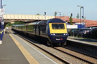
Princes Risborough station is a railway station on the Chiltern Main Line that serves the town of Princes Risborough in Buckinghamshire, England. It is operated by Chiltern Railways.

<span class="mw-page-title-main">Winchcombe railway station</span> Heritage railway station in Gloucestershire, England

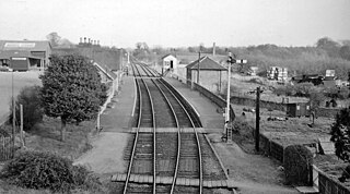
Winchcombe railway station is a heritage railway station which serves the town of Winchcombe in Gloucestershire, England. The stations itself is actually located in the nearby village of Greet. It is located on the Honeybourne Line which linked Cheltenham and Stratford-upon-Avon and which was opened by the Great Western Railway in 1906. The station closed to passengers in 1960, although the line itself remained open for freight and diversionary use until 1976, when a freight train derailed near Winchcombe and damaged the track.

<span class="mw-page-title-main">Toddington railway station</span> Heritage railway station in England

Toddington railway station serves the village of Toddington in Gloucestershire, England. Since 1984 it has been the main base of operations for the heritage Gloucestershire Warwickshire Railway.

<span class="mw-page-title-main">Honeybourne railway station</span> Railway station in Worcestershire, England

Honeybourne railway station serves the village of Honeybourne in Worcestershire, England. Opened in 1853, it is on the Cotswold Line and was formerly a busy junction with five platform faces, also serving trains on the Great Western Railway's Honeybourne Line between Cheltenham Spa and Stratford-upon-Avon, which formed part of a strategic route between the West Midlands and the West of England.

<span class="mw-page-title-main">Winslow Road railway station</span> Former Metropolitan Railway Station in Buckinghamshire

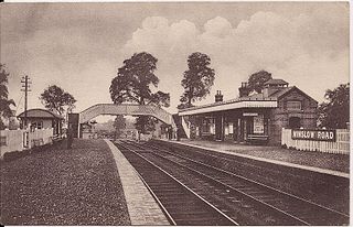
Winslow Road railway station served the village of East Claydon near Winslow to the north of Quainton in Buckinghamshire, England. It was the second station to serve the town after Winslow on the Varsity Line.

<span class="mw-page-title-main">Oxford Rewley Road railway station</span> Former railway station in England

Oxford Rewley Road railway station was a railway station serving the city of Oxford, England, located immediately to the north of what is now Frideswide Square on the site of the Saïd Business School, to the west of Rewley Road. It was the terminus of the Buckinghamshire Railway, which was worked, and later absorbed, by the London and North Western Railway (L&NWR). In 1923 it became part of the London, Midland and Scottish Railway (LMS), "Varsity Line" service from Cambridge via Bletchley and had features of significance in construction history.

<span class="mw-page-title-main">Claydon railway station</span> Disused railway station in Buckinghamshire, England

Claydon railway station is a former railway station on the 'Varsity Line', that served the village of Steeple Claydon in Buckinghamshire.

<span class="mw-page-title-main">Banbury Merton Street railway station</span> Disused railway station in Banbury, Cherwell

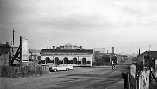
Banbury Merton Street was the first railway station to serve the Oxfordshire market town of Banbury in England. It opened in 1850 as the northern terminus of the Buckinghamshire Railway providing connections to Bletchley and Oxford and closing for passengers in 1961 and goods in 1966.

<span class="mw-page-title-main">Winslow railway station</span> Disused railway station in Buckinghamshire, England

Winslow railway station refers to either one of two railway stations which historically served or is planned to serve, the town of Winslow in north Buckinghamshire, England. The original station (1850–1968) was on the former Varsity Line between Cambridge and Oxford. As of August 2023, construction of a new station nears completion and is scheduled to be served by East West Rail, as part of the plan to reinstate the Oxford–Cambridge service.

<span class="mw-page-title-main">Swanbourne railway station</span> Former railway station in Buckinghamshire, England

Swanbourne was a railway station that served the villages of Swanbourne, Little Horwood and Mursley in north Buckinghamshire, England. It was on the mothballed Bicester to Bletchley line, roughly at the centre of a triangle drawn between the three villages. In summer 2020, the station was demolished to clear the route for East West Rail.

<span class="mw-page-title-main">Port Meadow Halt railway station</span> Former railway station in Oxfordshire, England

Port Meadow Halt was a railway station on the Varsity Line, between north Oxford and Port Meadow. The London & North Western Railway opened the halt as Summertown on 20 August 1906 and renamed it Port Meadow Halt in January 1907. It was closed between 1 January 1917 and 5 May 1919, and the London, Midland & Scottish Railway permanently closed it on 30 October 1926. It was located on the north side of a footbridge leading from the present-day Aristotle Lane into Port Meadow, close to an occupation crossing which also gave access to the up platform.

<span class="mw-page-title-main">Oxford Road Halt railway station</span> Disused railway station in Oxfordshire, England

Oxford Road Halt was a railway station on the Varsity Line 1 mile (1.6 km) west of the hamlet of Water Eaton, Oxfordshire.

<span class="mw-page-title-main">Brackley railway station</span> Former railway station in Northamptonshire, England

Brackley Town was a railway station which served the Northamptonshire town of Brackley in England. It opened in 1850 as part of the Buckinghamshire Railway's branch line to Verney Junction which provided connections to Banbury, Bletchley and Oxford and closed in 1963.

<span class="mw-page-title-main">Padbury railway station</span> Former railway station in Buckinghamshire, England

Padbury railway station served the village of Padbury in the English county of Buckinghamshire. It opened in 1878 as part of the Buckinghamshire Railway's branch line to Verney Junction which provided connections to Banbury, Bletchley and Oxford and closed in 1964.

<span class="mw-page-title-main">Yarnton railway station</span> Former railway station in Oxfordshire, England

Yarnton Junction was a three-platform station serving the village of Yarnton, Oxfordshire. It was built in 1861 at the junction of the Oxford, Worcester and Wolverhampton Railway and Witney Railway, north of Oxford. British Railways closed the station to passengers in 1962 and it was demolished c. 1965.

<span class="mw-page-title-main">Towcester railway station</span> Former railway station in Northamptonshire, England

Towcester was a railway station on the Stratford-upon-Avon and Midland Junction Railway which served the town of Towcester in Northamptonshire, England between 1866 and 1964.

<span class="mw-page-title-main">Westcott railway station</span> Railway station in Westcott, Buckinghamshire

Westcott railway station was a small station built to serve the village of Westcott, Buckinghamshire, and nearby buildings attached to Baron Ferdinand de Rothschild's estate at Waddesdon Manor. It was built by the Duke of Buckingham in 1871 as part of a short horse-drawn tramway to allow for the transport of goods from and around his extensive estates in Buckinghamshire and to connect the Duke's estates to the Aylesbury and Buckingham Railway at Quainton Road. A lobbying campaign by residents of the town of Brill led to the tramway being converted for passenger use and extended to Brill railway station in 1872, becoming known as the Brill Tramway.

The Banbury to Verney Junction branch line was a railway branch line constructed by the Buckinghamshire Railway which connected the Oxfordshire market town of Banbury with the former Oxford/Cambridge Varsity line and the former Metropolitan Railway at Verney Junction, a distance of 21 miles 39 chains. Onward routes from there ran to the West Coast Main Line at Bletchley via Brackley and Buckingham and thence to Cambridge, or to Aylesbury for London.

<span class="mw-page-title-main">Gretton Halt railway station</span> Former railway station in Scotland

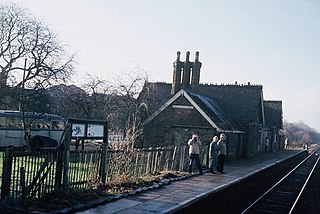
Gretton Halt railway station was a halt opened by the Great Western Railway on the Honeybourne Line from Honeybourne to Cheltenham which served the small village of Gretton in Gloucestershire between 1906 and 1960. The line through the site of the station was reinstated in 1997 by the Gloucestershire Warwickshire Railway, although no new halt was provided.

References

51°54′59″N1°03′19″W / 51.9163°N 1.0552°W / 51.9163; -1.0552