Related Research Articles

Jersey Shore is a borough in Lycoming County, Pennsylvania, United States. It is on the West Branch Susquehanna River, 15 miles (24 km) west by south of Williamsport. It is part of the Williamsport, Pennsylvania Metropolitan Statistical Area. In the past, Jersey Shore held farms, railroad shops, cigar factories, a foundry, and a large silk mill. The population was 4,158 at the 2020 census.

Washington Township is a township in Lycoming County, Pennsylvania, United States. The population was 1,769 at the 2020 census. It is part of the Williamsport Metropolitan Statistical Area.

Worlds End State Park is a 780-acre (316 ha) Pennsylvania state park in Sullivan County, Pennsylvania. The park, nearly surrounded by Loyalsock State Forest, is in the Loyalsock Creek valley on Pennsylvania Route 154 in Forks and Shrewsbury Townships southeast of the borough of Forksville. The name Worlds End has been used since at least 1872, but its origins are uncertain. Although it was founded as Worlds End State Forest Park by Governor Gifford Pinchot in 1932, the park was officially known as Whirls End State Forest Park from 1936 to 1943.

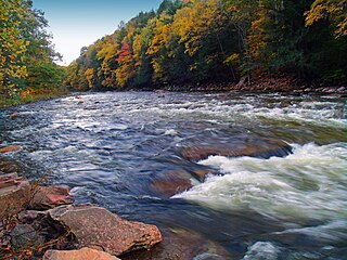
Loyalsock Creek is a 64-mile-long (103 km) tributary of the West Branch Susquehanna River located chiefly in Sullivan and Lycoming counties in Pennsylvania in the United States. As the crow flies, Lycoming County is about 130 miles (209 km) northwest of Philadelphia and 165 miles (266 km) east-northeast of Pittsburgh.

White Deer Hole Creek is a 20.5-mile (33.0 km) tributary of the West Branch Susquehanna River in Clinton, Lycoming and Union counties in the U.S. state of Pennsylvania. A part of the Chesapeake Bay drainage basin, the White Deer Hole Creek watershed drains parts of ten townships. The creek flows east in a valley of the Ridge-and-valley Appalachians, through sandstone, limestone, and shale from the Ordovician, Silurian, and Devonian periods.
Loyalsock State Forest is a Pennsylvania state forest in Pennsylvania Bureau of Forestry District #20. The forest spans across the northern tier's "Endless Mountains" and is a total of 114,552 acres (46,358 ha). The Loyalsock is a “working forest” and is managed for pure water, recreation, plant and animal habitats, sustainable timber, and natural gas.

Upper Pine Bottom State Park is a 5-acre (2.0 ha) Pennsylvania state park in Lycoming County, Pennsylvania in the United States. The park is in Cummings Township on Pennsylvania Route 44 and is surrounded by the Tiadaghton State Forest. It is on Upper Pine Bottom Run, which gave the park its name and is a tributary of Pine Creek. Upper Pine Bottom State Park is in the Pine Creek Gorge, where the streams have cut through five major rock formations from the Devonian and Carboniferous periods.
Colton Point State Park is a 368-acre (149 ha) Pennsylvania state park in Tioga County, Pennsylvania, in the United States. It is on the west side of the Pine Creek Gorge, also known as the Grand Canyon of Pennsylvania, which is 800 feet (240 m) deep and nearly 4,000 feet (1,200 m) across at this location. The park extends from the creek in the bottom of the gorge up to the rim and across part of the plateau to the west. Colton Point State Park is known for its views of the Pine Creek Gorge, and offers opportunities for picnicking, hiking, fishing and hunting, whitewater boating, and camping. Colton Point is surrounded by Tioga State Forest and its sister park, Leonard Harrison State Park, on the east rim. The park is on a state forest road in Shippen Township 5 miles (8 km) south of U.S. Route 6.

Black Moshannon State Park is a 3,480-acre (1,410 ha) Pennsylvania state park in Rush Township, Centre County, Pennsylvania, United States. It surrounds Black Moshannon Lake, formed by a dam on Black Moshannon Creek, which has given its name to the lake and park. The park is just west of the Allegheny Front, 9 miles (14 km) east of Philipsburg on Pennsylvania Route 504, and is largely surrounded by Moshannon State Forest. A bog in the park provides a habitat for diverse wildlife not common in other areas of the state, such as carnivorous plants, orchids, and species normally found farther north. As home to the "largest reconstituted bog in Pennsylvania", it was chosen by the Pennsylvania Department of Conservation and Natural Resources for its "25 Must-see Pennsylvania State Parks" list.
The Susquehanna and New York Railroad was a short-line railroad connecting the Lehigh Valley Railroad at Towanda, Pennsylvania, with the Pennsylvania Railroad at Marsh Hill Junction. The railroad carried freight and passengers between Williamsport and Towanda by rail rather than using the Susquehanna River or the Pennsylvania Canal.
The Susquehanna Boom was a system of cribs and chained logs in the West Branch Susquehanna River, designed to catch and hold floating timber until it could be processed at one of the nearly 60 sawmills along the river between Lycoming and Loyalsock Creeks in Lycoming County, Pennsylvania in the United States. The Susquehanna Boom was originally built under the supervision of James H. Perkins, and operated from 1851 to 1909, when it shut down for lack of timber.

The Pennsylvania Lumber Museum is near Galeton, Potter County, Pennsylvania in the United States. It documents the history and technology of the lumber industry that was a vital part of the economic development and ecological destruction of Pennsylvania.

Plunketts Creek is an approximately 6.2-mile-long (10 km) tributary of Loyalsock Creek in Lycoming and Sullivan counties in the U.S. state of Pennsylvania. Two unincorporated villages and a hamlet are on the creek, and its watershed drains 23.6 square miles (61 km2) in parts of five townships. The creek is a part of the Chesapeake Bay drainage basin via Loyalsock Creek and the West Branch Susquehanna and Susquehanna Rivers.

The Old Loggers Path is a 27.8 mi (44.7 km) hiking trail in north-central Pennsylvania, forming a loop through Loyalsock State Forest. The most commonly used trailhead is at the ghost town of Masten. The trail makes use of abandoned logging railroad grades originating in the late 1800s, and some roads originally built by the Civilian Conservation Corps in the 1930s. The trail is known for numerous vistas, rock formations, and scenic streams, and for the remnants of past industrial infrastructure reclaimed by the forest.

The Susquehanna and Eagles Mere Railroad was a logging railroad operating from 1902 to 1930 in Sullivan and Lycoming Counties in Pennsylvania in the United States.
Laquin, in Franklin Township, Bradford County, Pennsylvania, now a ghost town, was founded in 1902 as a lumber town, but when the forests played out and the mills could no longer be fed, the industry left, and the people soon followed. The population of Laquin at one time approached 2,000.
The Williamsport and North Branch Railroad was a short line that operated in north-central Pennsylvania between 1872 and 1937. After a long struggle to finance its construction, it was completed in 1893. It derived most of its freight revenue from logging and to a certain extent from anthracite coal traffic. It also carried many passengers to mountain resorts in Sullivan County, Pennsylvania. With the decline of the logging industry and increased accessibility of the region by automobile in the 1910s and 1920s, the railroad's business rapidly declined. The economic blow of the Great Depression proved insurmountable, and it was abandoned as unprofitable in 1937.

Ganoga Lake is a natural lake in Colley Township in southeastern Sullivan County in Pennsylvania, United States. Known as Robinson's Lake and Long Pond for most of the 19th century, the lake was purchased by the Ricketts family in the early 1850s and became part of R. Bruce Ricketts' extensive holdings in the area after the American Civil War. The lake is one of the highest in Pennsylvania, which led Ricketts to name it Highland Lake by 1874 and rename it Ganoga Lake in 1881; Pennsylvania senator Charles R. Buckalew suggested the name Ganoga from the Seneca language word for "water on the mountain".

Pine Creek Gorge, sometimes called The Grand Canyon of Pennsylvania, is a 47-mile (76 km) gorge carved into the Allegheny Plateau by Pine Creek in north-central Pennsylvania.

Leetonia is an unincorporated community in Elk Township, Tioga County, in the U.S. state of Pennsylvania. It lies along Leetonia Road, in the Tioga State Forest between Pennsylvania Route 414 and U.S. Route 6.
References
- 1 2 3 Taber III, Thomas T. (1970). "Chapter 3.2 Sonesville, Masten, and C.W. Sones". Ghost Lumber Towns of Central Pennsylvania: Laquin, Masten, Ricketts, Grays Run. Williamsport, Pennsylvania: Lycoming Print Co. OCLC 1044759.
- ↑ "Pennsylvania CCC Archive: Camp Information for S-80-Pa". Pennsylvania Department of Conservation and Natural Resources. Archived from the original on June 9, 2011. Retrieved September 29, 2007.
Municipalities and communities of Lycoming County, Pennsylvania, United States | ||
|---|---|---|
| City |  | |
| Boroughs | ||
| Townships |
| |
| CDPs | ||
| Unincorporated communities | ||
| Ghost town | ||
| Footnotes | ‡This populated place also has portions in an adjacent county | |