Brown Township, Lycoming County, Pennsylvania

Last updated
Brown Township,
Lycoming County,
Pennsylvania
Black Forest Remote.jpg
The village of Black Forest along PA 44
Map of Lycoming County Pennsylvania Highlighting Brown Township.png
Map of Lycoming County, Pennsylvania highlighting Brown Township
Map of Pennsylvania highlighting Lycoming County.svg
Map of Lycoming County, Pennsylvania
Coordinates: 41°29′30″N77°30′59″W / 41.49167°N 77.51639°W / 41.49167; -77.51639
Country United States
State Pennsylvania
County Lycoming
Settled1794
Formed1815
Area
[1]
  Total74.03 sq mi (191.74 km2)
  Land73.34 sq mi (189.96 km2)
  Water0.69 sq mi (1.78 km2)
Elevation
1,988 ft (606 m)
Population
 (2020) [2]
  Total92 Decrease2.svg
  Estimate 
(2021) [2]
92
  Density1.30/sq mi (0.50/km2)
Time zone UTC-5 (Eastern Time Zone (North America))
  Summer (DST) UTC-4 (EDT)
FIPS code 42-081-09280
GNIS feature ID1216742 [3]

Brown Township is a township in Lycoming County, Pennsylvania, United States. The population was 92 at the 2020 census. [2] It is part of the Williamsport, Pennsylvania Metropolitan Statistical Area.

Contents

History

Brown Township, named for Major General Jacob Brown of the War of 1812, was formed on May 3, 1815, by the Court of Quarter Sessions of the Peace of Lycoming County, from parts of Mifflin and Pine townships. Pine Creek and its gorge divide the township nearly in half, and it is the center of history in Brown Township. Pine Creek was a major waterway in the settlement of north-central Pennsylvania and in the lumber era that swept through Pennsylvania in the mid-to-late 19th century. Early pioneers were attracted to its remoteness and abundance of fish and game. [4]

Jacob Lamb, formerly of Milton, was the first documented European descendant to settle in the area. He arrived in late 1794 by paddling with his family and household supplies in ten canoes, up the West Branch Susquehanna River and Pine Creek to the mouth of Slate Run. Here, Lamb built his home. Jacob Lamb also constructed the first saw and gristmills in the area. [4]

Pioneer settler Jacob Tomb and his family established a home, sawmill, and gristmill at the mouth of Slate Run in the 1790s, and others settled nearby along the Pine Creek floodplain. By 1855, the village had a post office, general store, hotel, and two churches. [5]

Driving the local economy toward the end of the century was the James B. Weed and Company hemlock sawmill, which operated in Slate Run from 1886 to 1910 and produced up to 100,000 board feet of lumber a day. After the end of the lumber era, the mill closed, and the village declined in size. However, in the early 21st century, Slate Run still has a general store and post office, and a hotel with a restaurant and bar. [5]

Over the years Brown Township grew slowly, but it never gained a large population. It is largely a remote area, covered with mountains and a thriving second-growth forest. It is popular today with outdoor recreation enthusiasts. The population was 885 by the 1890 census and had declined to 96 people by the 2010 census.

The Bridge in Brown Township was added to the National Register of Historic Places in 1988. [6]

Geography

Brown Township is in the northwestern corner of the county, bordered by Clinton County to the southwest, Potter County to the west, Tioga County to the north, Pine Township to the east and McHenry Township to the south. Pine Creek Gorge cuts through the township from the northeastern corner to the middle of the southern border. The bottom of the gorge rises from 720 feet (220 m) at the southern border to 850 feet (260 m) at the northeast, more than 1,200 feet (370 m) below the surface of the Allegheny Plateau, which has summit elevations ranging from 2,000 to 2,148 feet (610 to 655 m) on the west side and up to 2,200 feet (670 m) on the east. [7]

Pennsylvania Route 44 crosses the western side of the township, on the surface of the Allegheny Plateau, passing through the small village of Black Forest. It leads southeastward 32 miles (51 km) to Jersey Shore in the valley of the West Branch Susquehanna River and northwestward 40 miles (64 km) to Coudersport on the Allegheny River. Pennsylvania Route 414 follows Pine Creek through the township, passing through the village of Slate Run in the bottom of the gorge. PA 414 leads northeastward (upstream) 16 miles (26 km) to Morris and south (downstream) 14 miles (23 km) to PA 44 near Waterville.

According to the United States Census Bureau, the township has a total area of 74.0 square miles (191.7 km2), of which 73.4 square miles (190.0 km2) are land and 0.7 square miles (1.8 km2), or 0.93%, are water. [1] Nearly all of the township drains directly to Pine Creek, which flows south to the West Branch Susquehanna River near Jersey Shore. The far western portion of the township drains west via Baldwin Branch and County Line Creek to Young Womans Creek, which flows southwestward to the West Branch at North Bend. Tiadaghton State Forest occupies much of the township.

Demographics

Historical population
CensusPop.Note
2010 96
2020 92−4.2%
2021 (est.)92 [2] 0.0%
U.S. Decennial Census [8]

As of the census [9] of 2000, there were 111 people, 56 households, and 38 families residing in the township. The population density was 1.5 people per square mile (0.6/km2). There were 353 housing units at an average density of 4.8/sq mi (1.9/km2). The racial makeup of the township was 100.00% White.

There were 56 households, out of which 10.7% had children under the age of 18 living with them, 64.3% were married couples living together, and 30.4% were non-families. 26.8% of all households were made up of individuals, and 10.7% had someone living alone who was 65 years of age or older. The average household size was 1.98 and the average family size was 2.36.

In the township the population was spread out, with 10.8% under the age of 18, 0.9% from 18 to 24, 16.2% from 25 to 44, 37.8% from 45 to 64, and 34.2% who were 65 years of age or older. The median age was 56 years. For every 100 females there were 122.0 males. For every 100 females age 18 and over, there were 125.0 males.

The median income for a household in the township was $41,250, and the median income for a family was $55,833. Males had a median income of $24,583 versus $16,667 for females. The per capita income for the township was $22,970. There were 5.6% of families and 4.9% of the population living below the poverty line, including no under eighteens and none of those over 64.

See also

For histories of the other townships in Lycoming County see

History of the Townships of Lycoming County, Pennsylvania

Related Research Articles

<span class="mw-page-title-main">Lycoming County, Pennsylvania</span> County in Pennsylvania, United States

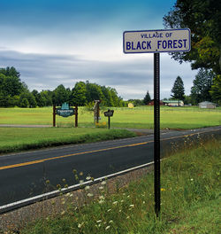
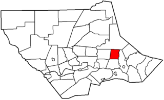
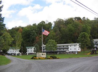
Lycoming County is a county in the Commonwealth of Pennsylvania. As of the 2020 census, the population was 114,188. Its county seat is Williamsport.

<span class="mw-page-title-main">Anthony Township, Lycoming County, Pennsylvania</span> Township in Pennsylvania, United States

Anthony Township is a township in Lycoming County, Pennsylvania, United States. The population was 866 at the 2020 census. It is part of the Williamsport, Pennsylvania Metropolitan Statistical Area.

<span class="mw-page-title-main">Bastress Township, Lycoming County, Pennsylvania</span> Township in Pennsylvania, United States

Bastress Township is a township in Lycoming County, Pennsylvania, United States. The population was 528 at the 2020 census. It is part of the Williamsport, Pennsylvania Metropolitan Statistical Area.

<span class="mw-page-title-main">Cascade Township, Pennsylvania</span> Township in Pennsylvania, United States

Cascade Township is a township in Lycoming County, Pennsylvania, United States. The population was 420 at the 2020 census. It is part of the Williamsport, Pennsylvania Metropolitan Statistical Area.

<span class="mw-page-title-main">Cogan House Township, Lycoming County, Pennsylvania</span> Township in Pennsylvania, United States

Cogan House Township is a township in Lycoming County, Pennsylvania, United States. The population was 930 at the 2020 census. It is part of the Williamsport, Pennsylvania Metropolitan Statistical Area.

<span class="mw-page-title-main">Cummings Township, Lycoming County, Pennsylvania</span> Township in Pennsylvania, United States

Cummings Township is a township in Lycoming County, Pennsylvania, United States. The population was 264 at the 2020 census, down from 273 in 2010. It is part of the Williamsport, Pennsylvania Metropolitan Statistical Area. Cummings Township is home to Little Pine State Park and Upper Pine Bottom State Park.

<span class="mw-page-title-main">Gamble Township, Lycoming County, Pennsylvania</span> Township in Pennsylvania, United States

Gamble Township is a township in Lycoming County, Pennsylvania, United States. The population was 780 at the 2020 census, up from 756 in 2010. It is part of the Williamsport Metropolitan Statistical Area.

<span class="mw-page-title-main">Jackson Township, Lycoming County, Pennsylvania</span> Township in Pennsylvania, United States

Jackson Township is a township in Lycoming County, Pennsylvania, United States. The population was 394 at the 2020 census. It is part of the Williamsport Metropolitan Statistical Area.

<span class="mw-page-title-main">Lewis Township, Lycoming County, Pennsylvania</span> Township in Pennsylvania, United States

Lewis Township is a township in Lycoming County, Pennsylvania, United States. The population was 987 at the 2010 census, down from 1,139 in 2000. It is part of the Williamsport Metropolitan Statistical Area.

<span class="mw-page-title-main">Lycoming Township, Pennsylvania</span> Township in Pennsylvania, United States

Lycoming Township is a township in Lycoming County, Pennsylvania, United States. The population was 1,490 at the 2020 census. It is part of the Williamsport Metropolitan Statistical Area.

<span class="mw-page-title-main">McHenry Township, Pennsylvania</span> Township in Pennsylvania, United States

McHenry Township is a township in Lycoming County, Pennsylvania, United States. The population was 121 at the 2020 census. It is part of the Williamsport Metropolitan Statistical Area.

<span class="mw-page-title-main">McNett Township, Pennsylvania</span> Township in Pennsylvania, United States

McNett Township is a township in Lycoming County, Pennsylvania, United States. The population was 145 at the 2020 census, down from 174 in 2010. It is part of the Williamsport Metropolitan Statistical Area.

<span class="mw-page-title-main">Mifflin Township, Lycoming County, Pennsylvania</span> Township in Pennsylvania, United States

Mifflin Township is a township in Lycoming County, Pennsylvania, United States. The population was 1,088 at the 2020 census. It is part of the Williamsport Metropolitan Statistical Area.

<span class="mw-page-title-main">Mill Creek Township, Lycoming County, Pennsylvania</span> Township in Pennsylvania, United States

Mill Creek Township is a township in Lycoming County, Pennsylvania, United States. The population was 580 at the 2020 census. It is part of the Williamsport Metropolitan Statistical Area.

<span class="mw-page-title-main">Old Lycoming Township, Pennsylvania</span> Township in Pennsylvania, United States

Old Lycoming Township is a township in Lycoming County, Pennsylvania, United States. The population was 4,973 at the 2020 census down from 4,938 in 2010. It is part of the Williamsport Metropolitan Statistical Area.

<span class="mw-page-title-main">Piatt Township, Pennsylvania</span> Township in Pennsylvania, United States

Piatt Township is a township in Lycoming County, Pennsylvania, United States. The population was 1,045 at the 2020 census. It is part of the Williamsport Metropolitan Statistical Area.

<span class="mw-page-title-main">Porter Township, Lycoming County, Pennsylvania</span> Township in Pennsylvania, United States

Porter Township is a township in Lycoming County, Pennsylvania, United States. The population was 1,535 at the 2020 census. It is part of the Williamsport Metropolitan Statistical Area.

<span class="mw-page-title-main">Washington Township, Lycoming County, Pennsylvania</span> Township in Pennsylvania, United States

Washington Township is a township in Lycoming County, Pennsylvania, United States. The population was 1,769 at the 2020 census. It is part of the Williamsport Metropolitan Statistical Area.

<span class="mw-page-title-main">Watson Township, Lycoming County, Pennsylvania</span> Township in Pennsylvania, United States

Watson Township is a township in Lycoming County, Pennsylvania, United States. The population was 534 at the 2020 census. It is part of the Williamsport Metropolitan Statistical Area.

<span class="mw-page-title-main">Woodward Township, Lycoming County, Pennsylvania</span> Township in Pennsylvania, United States

Woodward Township is a township in Lycoming County, Pennsylvania, United States. The population was 2,043 at the 2020 census, down from 2,200 in 2010. It is part of the Williamsport Metropolitan Statistical Area.

References

  1. 1 2 "2016 U.S. Gazetteer Files". United States Census Bureau. Retrieved Aug 14, 2017.
  2. 1 2 3 4 Bureau, US Census. "City and Town Population Totals: 2020-2021". Census.gov. US Census Bureau. Retrieved 15 July 2022.
  3. "US Board on Geographic Names". United States Geological Survey. 2007-10-25. Retrieved 2008-01-31.
  4. 1 2 Meginness, John Franklin (1892). "Brown, Cummings, Pine, and McHenry". History of Lycoming County, Pennsylvania: including its aboriginal history; the colonial and revolutionary periods; early settlement and subsequent growth; organization and civil administration; the legal and medical professions; internal improvement; past and present history of Williamsport; manufacturing and lumber interests; religious, educational, and social development; geology and agriculture; military record; sketches of boroughs, townships, and villages; portraits and biographies of pioneers and representative citizens, etc. etc (1st ed.). Chicago: Brown, Runk & Co. ISBN   0-7884-0428-8 . Retrieved 2007-02-20. (Note: ISBN refers to Heritage Books July 1996 reprint. URL is to a scan of the 1892 version with some OCR typos).
  5. 1 2 Kagan, David Ira (2008). Pine Creek Villages. Charleston, South Carolina: Arcadia Publishing. pp. 77–98. ISBN   978-0-7385-5663-5.
  6. "National Register Information System". National Register of Historic Places . National Park Service. July 9, 2010.
  7. "Slate Run, PA". ACME Mapper. U.S. Geological Survey 7-1/2 minute topographic map series. Retrieved November 5, 2020.
  8. "Census of Population and Housing". Census.gov. Retrieved June 4, 2016.
  9. "U.S. Census website". United States Census Bureau . Retrieved 2008-01-31.