
Sullivan County is a county in the Commonwealth of Pennsylvania. It is part of Northeastern Pennsylvania. As of the 2020 census, the population was 5,840, making it the second-least populous county in Pennsylvania. Its county seat is Laporte. The county was created on March 15, 1847, from part of Lycoming County and named for Major General John Sullivan.

Lycoming County is a county in the Commonwealth of Pennsylvania. As of the 2020 census, the population was 114,188. Its county seat is Williamsport.

Bastress Township is a township in Lycoming County, Pennsylvania, United States. The population was 528 at the 2020 census. It is part of the Williamsport, Pennsylvania Metropolitan Statistical Area.
Clinton Township is a township in Lycoming County, Pennsylvania, United States. The population was 3,719 at the 2020 census, up from 3,708 in 2010. It is part of the Williamsport, Pennsylvania Metropolitan Statistical Area.

Cogan House Township is a township in Lycoming County, Pennsylvania, United States. The population was 930 at the 2020 census. It is part of the Williamsport, Pennsylvania Metropolitan Statistical Area.

Jersey Shore is a borough in Lycoming County, Pennsylvania, United States. It is on the West Branch Susquehanna River, 15 miles (24 km) west by south of Williamsport. It is part of the Williamsport, Pennsylvania Metropolitan Statistical Area. In the past, Jersey Shore held farms, railroad shops, cigar factories, a foundry, and a large silk mill. The population was 4,158 at the 2020 census.
Limestone Township is a township in Lycoming County, Pennsylvania, United States. The population was 1,968 at the 2020 census. It is part of the Williamsport Metropolitan Statistical Area.

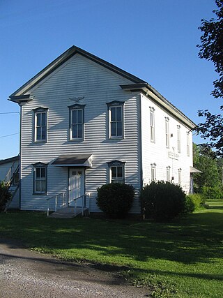
Nippenose Township is a township in Lycoming County, Pennsylvania, United States. The population was 662 at the 2020 census. It is part of the Williamsport, Pennsylvania Metropolitan Statistical Area.

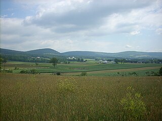
Porter Township is a township in Lycoming County, Pennsylvania, United States. The population was 1,535 at the 2020 census. It is part of the Williamsport Metropolitan Statistical Area.

Susquehanna Township is a township in Lycoming County, Pennsylvania, United States. The population was 972 at the 2020 census. It is part of the Williamsport Metropolitan Statistical Area.

Washington Township is a township in Lycoming County, Pennsylvania, United States. The population was 1,769 at the 2020 census. It is part of the Williamsport Metropolitan Statistical Area.

White Deer Hole Creek is a 20.5-mile (33.0 km) tributary of the West Branch Susquehanna River in Clinton, Lycoming and Union counties in the U.S. state of Pennsylvania. A part of the Chesapeake Bay drainage basin, the White Deer Hole Creek watershed drains parts of ten townships. The creek flows east in a valley of the Ridge-and-valley Appalachians, through sandstone, limestone, and shale from the Ordovician, Silurian, and Devonian periods.

Rauchtown Run, named Rauchtown Creek on United States Geological Survey maps, is a tributary of the West Branch Susquehanna River in Clinton and Lycoming Counties, Pennsylvania, in the United States.

Pennsylvania Route 880 is a 25-mile-long (40 km) state highway located in Centre, Clinton, and Lycoming counties in Pennsylvania. The southern terminus is at PA 192 in Miles Township. The northern terminus is at PA 44 in Limestone Township Though it does not have a direct junction with Interstate 80 (I-80), it underpasses the highway in Carroll and drivers can enter I-80 one mile (1.6 km) east by turning left onto East Valley Road. South of this intersection, PA 880 is known as East Valley Road until Loganton, where it becomes Main Street. South of Loganton it continues as West Valley Road until the Centre County line. From there until its southern terminus it serves as Broad Street in Rebersburg. North of the East Valley Road intersection, PA 880 becomes Rauchtown Road until entering Lycoming County.
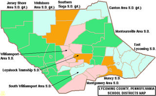
The Jersey Shore Area School District is a large rural, American, public school district that is located in Lycoming County, Pennsylvania and Clinton County, Pennsylvania. The district, which encompasses approximately 385 square miles (1,000 km2), is centered on the borough of Jersey Shore and serves the surrounding Lycoming County municipalities of Limestone Township, Bastress Township, Nippenose Township, Porter Township, Piatt Township, Anthony Township, Mifflin Township, Watson Township, Cummings Township, McHenry Township, Brown Township, and Salladasburg.
Faxon is a census-designated place (CDP) in Loyalsock Township, Lycoming County, Pennsylvania, United States. As of the 2010 census, it had a population of 1,395. Faxon is not a separately incorporated community, but is a part of Loyalsock Township.
Kenmar is a census-designated place (CDP) in Loyalsock Township, Lycoming County, Pennsylvania, United States. As of the 2010 census, it had a population of 4,124. Kenmar is not a separately incorporated community, but is a part of Loyalsock Township.
Oval is a census-designated place (CDP) in Limestone Township, Lycoming County, Pennsylvania, United States. As of the 2010 census, it had a population of 361. Oval is not a separately incorporated community, but is a part of Limestone Township.


