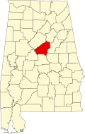
Maylene, Alabama

Last updated

Maylene, Alabama
USA Alabama location map.svg
Red pog.svg
Maylene, Alabama
Usa edcp location map.svg
Red pog.svg
Maylene, Alabama
Coordinates: 33°12′12″N86°51′42″W / 33.20333°N 86.86167°W / 33.20333; -86.86167
CountryUnited States
State Alabama
County Shelby
Elevation
492 ft (150 m)
Time zone UTC−6 (Central (CST))
  Summer (DST) UTC−5 (CDT)
ZIP code
35114
Area code(s) 205, 659
GNIS feature ID122423 [1]

Maylene is an unincorporated community in Shelby County, Alabama, United States. While the community was once unincorporated, it is now part of southern Alabaster. [1] [2] Maylene has a post office with ZIP code 35114. [3] [4] One site in Maylene, the Meredith-McLaughlin House (McLaughlin Farm), is listed on the Alabama Register of Landmarks and Heritage. [5]

Notable people

Related Research Articles

Natural Bridge is an unincorporated community in Rockbridge County, Virginia, United States. The community is the site of Natural Bridge, a natural arch which gives the town its name. Natural Bridge is located at the junction of U.S. Route 11 and State Route 130. Natural Bridge has a post office with ZIP code 24578, which opened on June 1, 1800.

Lakewood is an unincorporated community and Census Designated Place in Lakewood Township, Shelby County, Illinois, United States. Lakewood is located on County Highway 12, 8 miles (13 km) southwest of Shelbyville. Lakewood had a post office, which opened on July 26, 1872, and closed on November 2, 2002.

Hatchechubbee is an unincorporated community in Russell County, Alabama, United States. Hatchechubbee is located at the junction of Alabama State Route 26 and County Route 65, 6.5 miles (10.5 km) west-southwest of Seale. Hatchechubbee has a post office with ZIP code 36858, which opened on August 17, 1855. The community's name is derived from the Creek words hachi meaning "creek" and chaba meaning "halfway".

<span class="mw-page-title-main">Perdido, Alabama</span> Census-designated place in Alabama, United States

Perdido, also known as Perdido Station, is an unincorporated community and census-designated place in Baldwin County, Alabama, United States. Perdido is located along County Route 61, 12.2 miles (19.6 km) northeast of Bay Minette. Perdido has a post office with ZIP code 36562. It has an elementary school, Perdido School, which is part of the Baldwin County Board of Education.

Sunflower is an unincorporated community in Washington County, Alabama, United States, located 8.1 miles (13.0 km) north of McIntosh. Sunflower has a post office with ZIP code 36581.

Frankville is an unincorporated community in Washington County, Alabama, United States, located on County Route 31, 9.8 miles (15.8 km) east of Millry. Frankville has a post office with ZIP code 36538.

Clopton is an unincorporated community and census-designated place (CDP) in Dale County, Alabama, United States. Clopton is located on Alabama State Route 105, 10.9 miles (17.5 km) west-northwest of Abbeville.

Skipperville is an unincorporated community in Dale County, Alabama, United States. Skipperville is located on Alabama State Route 105, 8.8 miles (14.2 km) northeast of Ozark. Skipperville has a post office with ZIP code 36374, which opened on November 10, 1853. This community also consists of G.W. Long School, which has won a 2a state championship for baseball in many previous years. This school also has other sports teams with state wide victories.

Bellwood is an unincorporated community in Geneva County, Alabama, United States. Bellwood is located on Alabama State Route 85, 10.5 miles (16.9 km) north-northeast of Geneva. Bellwood has a post office with ZIP code 36313.

Shorterville is an unincorporated community in Henry County, Alabama, United States. Shorterville is located on Alabama State Route 10, 8.8 miles (14.2 km) east of Abbeville. Shorterville has a post office with ZIP code 36373.

<span class="mw-page-title-main">Highland Home, Alabama</span> Unincorporated community in Alabama, United States

Highland Home is an unincorporated community in Crenshaw County, Alabama, United States. Highland Home is located on U.S. Route 331, 16.6 miles (26.7 km) north of Luverne. Highland Home has a post office with ZIP code 36041, which opened on July 15, 1837. Located mostly on highway 331 that also runs to Luverne, Alabama.

<span class="mw-page-title-main">Oyster Bay, Alabama</span> Unincorporated community in Alabama, United States

Oyster Bay is an unincorporated community in Baldwin County, Alabama, United States. Oyster Bay is located at the mouth of the Bon Secour River into Bon Secour Bay, 3.4 miles (5.5 km) west of Gulf Shores. The Nicholson House, which is listed on the National Register of Historic Places, is located in Oyster Bay.

<span class="mw-page-title-main">Estillfork, Alabama</span> Unincorporated community in Alabama, United States

Estillfork is an unincorporated community in Jackson County, Alabama, United States. It is located in a rugged area at the head of the Paint Rock Valley in northern Jackson County. Just south of the community, the stream with which it shares its name, Estill Fork, joins Hurricane Creek to form the Paint Rock River. The Cumberland Plateau rises immediately to the east, and the Alabama-Tennessee state line passes a few miles to the north.

Abernant is an unincorporated community in Tuscaloosa County, Alabama, United States. Abernant is located along Alabama State Route 216, 3.6 miles (5.8 km) west of Lake View. Abernant has a post office with ZIP code 35440.

Alton is an unincorporated community in Jefferson County, Alabama, United States. Alton is located along Interstate 459, 10 miles (16 km) east-northeast of downtown Birmingham. Alton has a post office with ZIP code 35015. Part of the community has been annexed into the city of Birmingham, while the remainder remains an unincorporated area surrounded by the city.

New Castle is an unincorporated community in Jefferson County, Alabama, United States. New Castle is 9 miles (14 km) north of downtown Birmingham. New Castle has a post office with ZIP code 35119. New Castle was formerly home to coal mines operated by John T. Milner.

Fourmile, also known as Redlawn, is an unincorporated community in Shelby County, Alabama, United States. Fourmile is located 4 miles (6.4 km) northeast of Columbiana and 3 miles (4.8 km) west of Wilsonville. Some of the early settlers of Fourmile came from Lexington County and Newberry County, South Carolina.

Arkwright was an unincorporated community in Shelby County, Alabama, United States. The community lies near the banks of the Coosa River and is now within the city limits of Vincent. Arkwright was founded in 1907 and was named for Preston Stanley Arkwright, who served as founder and president of Georgia Railway and Power Company and as an official with the Atlanta, Birmingham and Atlantic Railway. At one point, the community was home to a railroad station, post office, bank, cotton gin, gristmill, general store, furniture store, and school. The post office was in operation from 1909 to 1926. In 1924, the railroad company raised the railroad bed, eliminating the need for a depot. The population soon began to decline and the post office was closed shortly afterwards. The Arkwright Baptist Church and Arkwright Heritage Area, which includes multiple structures and cemeteries, were added to the Alabama Register of Landmarks and Heritage in 2011.

Ethridge is an unincorporated community in Toole County, Montana, United States. It is located 12.6 miles (20.3 km) west-northwest of Shelby. It is located on U.S. Route 2, and is a grain storage and shipping point on the Hi-Line. The community has a post office with ZIP code 59435.

Galata is an unincorporated community in Toole County, Montana, United States. The community has a post office with ZIP code 59444, which opened on July 12, 1902.

References

  1. 1 2 "Maylene". Geographic Names Information System . United States Geological Survey, United States Department of the Interior.
  2. Shelby County Highway Functional Classification System (PDF) (Map). Alabama Department of Transportation. 2004. Archived from the original (PDF) on February 21, 2014.
  3. United States Postal Service (2012). "USPS – Look Up a ZIP Code" . Retrieved February 15, 2012.
  4. "Postmaster Finder – Post Offices by ZIP Code". United States Postal Service. Archived from the original on October 17, 2020. Retrieved June 7, 2013.
  5. "Properties on the Alabama Register of Landmarks & Heritage". Alabama Historical Commission. www.preserveala.org. Archived from the original on September 4, 2012. Retrieved June 5, 2014.