Alabaster, Alabama

Last updated

Alabaster, Alabama
Alabaster Hwy 31.jpg
Aerial view of Highway 31 in Alabaster, AL
Flag of Alabaster, Alabama.png
Logo of Alabaster, Alabama.png
Shelby County Alabama Incorporated and Unincorporated areas Alabaster Highlighted 0100820.svg
Location of Alabaster in Shelby County, Alabama.
USA Alabama location map.svg
Red pog.svg
Alabaster
Coordinates: 33°13′52″N86°49′25″W / 33.23111°N 86.82361°W / 33.23111; -86.82361
Country United States
State Alabama
County Shelby
EstablishedFebruary 23, 1953
Government
  MayorScott Brakefield
  City AdministratorBrian Binzer
Area
[1]
  Total25.59 sq mi (66.29 km2)
  Land25.28 sq mi (65.47 km2)
  Water0.31 sq mi (0.81 km2)
Elevation
[2]
584 ft (178 m)
Population
 (2020)
  Total33,284
Time zone UTC-6 (Central (CST))
  Summer (DST) UTC-5 (CDT)
ZIP code
35007, 35114
Area codes 205, 659
FIPS code 01-00820
GNIS feature ID2403069 [2]
Website Official website

Alabaster is a city and southern suburb of Birmingham in Shelby County, Alabama, United States. At the 2020 census, the population was 33,284. Alabaster is the 16th largest city in Alabama by number of residents. [3]

Contents

History

George L. Scott Sr., an Alabaster pioneer, owned and operated Alabaster Lime Co., which mined this mineral. His shipping point was known as “Scott Rock.” Later, worker housing was built to accommodate some of the mine employees. The community was named Alabaster after the "white calcium carbonate mineral."[ citation needed ]

The First Bank of Alabaster opened in 1952, and its president was George L. Scott Jr., who later was elected as the first mayor of Alabaster. The first attempt in 1952 to incorporate Alabaster failed. In January 1953, the petition was again filed, and on February 23, 1953, Alabaster was officially incorporated, with a favorable vote of 79 to 23, and 427 residing inhabitants. In 1955, the Alabaster Water and Gas Board was formed. [4]

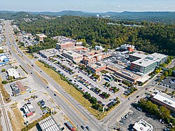
In 2015, the city announced that it was considering options to expand the area commonly known as the "Main Street Medical Mile" along Highway 31. The plans include not just expansion of medical facilities, but a civic center and different retail locations. [5]

Additionally, it was announced in 2017 that a 350,000 square feet retail complex would be built at the corner of Highway 31 and Interstate 65. The new complex, currently named District 31, was slated to open in 2019, [6] however as of 2020, the complex remained under construction.

Geography

Alabaster is located at 33°13′52″N86°49′26″W / 33.23111°N 86.82389°W / 33.23111; -86.82389 (33.231162, −86.823829). [7]

Alabaster mostly occupies the Cahaba and Opossum valleys, which are divided by the Pine Ridge that runs north to south. To the east and west, both valleys are flanked by parallel mountain ridges that locally run north to south, but are a part of a larger system of ridges that generally runs north-east to south-west (the tailing ends of the Appalachian foothills). The valleys are drained by small creeks (Buck Creek, Beaverdam Creek) that flow into the Cahaba River. [8]

Access to the city from major highways is found from U.S. Route 31, which runs through the city, and via I-65 exit 238. Downtown Birmingham is 23 mi (37 km) north, and Montgomery is 69 mi (111 km) south, both via US-31 or I-65.

According to the U.S. Census Bureau, the city has a total area of 25.6 square miles (66.3 km2), of which 25.3 square miles (65.5 km2) is land and 0.3 square miles (0.8 km2) (1.2%) is water. [1]

Climate

According to the Köppen Climate Classification system, Alabaster has a humid subtropical climate, abbreviated "Cfa" on climate maps.

Climate data for Alabaster, Alabama (Shelby County Airport), 19912020 normals, extremes 1995present
MonthJanFebMarAprMayJunJulAugSepOctNovDecYear
Record high °F (°C)80
(27)
82
(28)
87
(31)
90
(32)
96
(36)
105
(41)
104
(40)
105
(41)
101
(38)
101
(38)
89
(32)
81
(27)
105
(41)
Mean maximum °F (°C)72.7
(22.6)
76.1
(24.5)
82.2
(27.9)
86.1
(30.1)
91.6
(33.1)
95.7
(35.4)
96.5
(35.8)
97.1
(36.2)
93.9
(34.4)
88.5
(31.4)
77.9
(25.5)
74.9
(23.8)
98.6
(37.0)
Mean daily maximum °F (°C)55.7
(13.2)
60.5
(15.8)
67.9
(19.9)
75.4
(24.1)
82.5
(28.1)
88.3
(31.3)
91.1
(32.8)
90.8
(32.7)
86.1
(30.1)
76.3
(24.6)
66.0
(18.9)
58.0
(14.4)
74.9
(23.8)
Daily mean °F (°C)45.7
(7.6)
49.9
(9.9)
57.0
(13.9)
64.0
(17.8)
71.8
(22.1)
78.5
(25.8)
81.3
(27.4)
80.9
(27.2)
75.8
(24.3)
65.1
(18.4)
54.6
(12.6)
48.2
(9.0)
64.4
(18.0)
Mean daily minimum °F (°C)35.6
(2.0)
39.3
(4.1)
46.0
(7.8)
52.6
(11.4)
61.0
(16.1)
68.7
(20.4)
71.6
(22.0)
71.0
(21.7)
65.5
(18.6)
53.9
(12.2)
43.1
(6.2)
38.3
(3.5)
53.9
(12.2)
Mean minimum °F (°C)18.3
(−7.6)
24.2
(−4.3)
29.7
(−1.3)
38.3
(3.5)
47.9
(8.8)
61.3
(16.3)
65.0
(18.3)
64.4
(18.0)
53.5
(11.9)
37.3
(2.9)
26.9
(−2.8)
24.3
(−4.3)
17.2
(−8.2)
Record low °F (°C)9
(−13)
4
(−16)
14
(−10)
28
(−2)
37
(3)
49
(9)
56
(13)
55
(13)
42
(6)
31
(−1)
21
(−6)
10
(−12)
4
(−16)
Average precipitation inches (mm)5.35
(136)
5.76
(146)
5.40
(137)
5.07
(129)
4.15
(105)
4.58
(116)
4.93
(125)
4.72
(120)
3.57
(91)
3.03
(77)
4.56
(116)
5.07
(129)
56.19
(1,427)
Average snowfall inches (cm)0.1
(0.25)
0.2
(0.51)
0.1
(0.25)
0.0
(0.0)
0.0
(0.0)
0.0
(0.0)
0.0
(0.0)
0.0
(0.0)
0.0
(0.0)
0.0
(0.0)
0.0
(0.0)
0.3
(0.76)
0.7
(1.77)
Average precipitation days (≥ 0.01 in)10.811.411.59.79.911.512.811.58.08.29.011.3125.6
Average snowy days (≥ 0.1 in)0.20.20.10.00.00.00.00.00.00.00.00.10.6
Source 1: NOAA [9]
Source 2: National Weather Service (mean maxima/minima, snow/snow days 20062020) [10]

Demographics

City of Alabaster (1960-)

Alabaster first appeared on the 1960 U.S. Census as an incorporated city. [11]

Historical population
CensusPop.Note
1960 1,623
1970 2,64262.8%
1980 7,079167.9%
1990 14,732108.1%
2000 22,61953.5%
2010 30,35234.2%
2020 33,2849.7%
U.S. Decennial Census [12]

2010 Census data

As of the census of 2010, there were 30,352 people, 11,016 households, and 6,482 families residing in the city [9]. The population density was 1,104.8 inhabitants per square mile (426.6/km2). The racial makeup of the city was 81.2% White, 15.0% Black or African American, 0.31% Native American, 0.64% Asian, 0.02% Pacific Islander, 2.2% from other races, and 0.69% from two or more races. 4.54% of the population were Hispanic or Latino of any race.

There were 11,016 households, out of which 41.9% had children under the age of 18 living with them, 68.0% were married couples living together, 8.9% had a female householder with no husband present, and 20.6% were non-families. 17.1% of all households were made up of individuals, and 3.6% had someone living alone who was 65 years of age or older. The average household size was 2.73 and the average family size was 3.09.

In the city, the population was spread out, with 27.7% under the age of 18, 7.0% from 18 to 24, 32.0% from 25 to 44, 25.0% from 45 to 64, and 8.0% who were 65 years of age or older. The median age was 35 years. For every 100 females, there were 94.7 males. For every 100 females age 18 and over, there were 90.7 males.

The median income for a household in the city was $64,411, and the median income for a family was $78,940. The per capita income for the city was $22,466. About 4.3% of families and 5.9% of the population were below the poverty line, including 7.0% of those under age 18 and 12.3% of those age 65 or over.

2020 Census data

Alabaster Racial Composition [13]
RaceNum.Perc.
White 21,79165.47%
Black or African American 5,30015.92%
Native American 630.19%
Asian 3941.18%
Pacific Islander 200.06%
Other/Mixed 1,5004.51%
Hispanic or Latino 4,21612.67%

As of the 2020 United States Census, there were 33,284 people, 11,568 households, and 8,667 families residing in the city.

Alabaster-Helena Census Division (1980-)

Historical population
CensusPop.Note
1980 33,674
1990 59,09075.5%
2000 86,78146.9%
2010 118,83136.9%
U.S. Decennial Census [14]

The Alabaster-Helena Census Division was created in 1980 through the merger of the former Helena Division and Siluria Divisions. [15] It includes portions of Alabaster, Birmingham (Shelby County portion), Brantleyville, Calera, Chelsea, Helena, Hoover, Indian Springs Village, Meadowbrook, Montevallo, Pelham and Vestavia Hills. [16]

Government

The government consists of a mayor, who is elected at-large, and a seven-member city council. Each member is elected from a single-member district, called a ward, of roughly equal population.

The Mayor and City Council are elected every four years. The most recent election was held in 2020.

The current City Council Members are: Sophie Martin, Rick Ellis, Stacy Rakestraw, Greg Farrell, Jamie Cole, Zach Zahariadis, and Kerri Pate.


Alabaster Fire Department ISO Class 2 rated. Consisting of 3 Firehouses with 61 Full Time Firefighters.

Alabaster Firehouse #1 Located at 890 1st Avenue West.

Alabaster Firehouse #2 Located at 950 Butler Road.

AFDFT.jpg

Alabaster Firehouse #3 Located at 910 1st Street South (US 31 South)

City Council

DistrictNamePosition
1Mrs. Sophie MartinPresident
2Mr. Rick EllisCouncilperson
3Mrs. Stacy RakestrawCouncilperson
4Mr. Greg FarrellPresident Pro-Temp
5Mr. Jamie ColeCouncilperson
6Zach ZahariadisCouncilperson
7Ms. Kerri Bell-PateCouncilperson

Schools

On July 1, 2013, the Alabaster City Schools System officially separated from the Shelby County Schools system, and now operates the public schools in the city. [17] Private school K-12 education is also available.

Private:

Related Research Articles

<span class="mw-page-title-main">Coosa County, Alabama</span> County in Alabama, United States

Coosa County is located in the east central portion of the U.S. state of Alabama. As of the 2020 census the population was 10,387. Its county seat is Rockford. Its name derives from a town of the Creek tribe and the Coosa River, which forms one of the county borders.

<span class="mw-page-title-main">Shelby County, Alabama</span> County in Alabama, United States

Shelby County is located in the central portion of the U.S. state of Alabama. As of the 2020 census the population was 223,024, making it the sixth-most populous county in Alabama. The county seat is Columbiana. Its largest city is Alabaster. The county is named in honor of Isaac Shelby, Governor of Kentucky from 1792 to 1796 and again from 1812 to 1816. Shelby County is included in the Birmingham–Hoover, AL Metropolitan Statistical Area.

<span class="mw-page-title-main">Talladega County, Alabama</span> County in Alabama, United States

Talladega County is one of the sixty-seven counties located in the east central portion of the U.S. state of Alabama. As of the 2020 census, the population was 82,149. Its county seat is Talladega.

<span class="mw-page-title-main">Calera, Alabama</span> City in Alabama, United States

Calera is a city in Shelby and Chilton counties in the U.S. state of Alabama. It is the location of the Shelby County Airport.

<span class="mw-page-title-main">Helena, Alabama</span> City in Alabama, United States

Helena is a city in Jefferson and Shelby counties in the state of Alabama. Helena is considered a suburb of Birmingham and part of the Birmingham-Hoover Metropolitan Area. As of 2022 the United States Census Bureau estimates the population to be 21,862.

<span class="mw-page-title-main">Homewood, Alabama</span> City in Alabama, United States

Homewood is a city in southeastern Jefferson County, Alabama, United States. It is a suburb of Birmingham, located on the other side of Red Mountain due south of the city center. The population was 26,414 at the 2020 census.

<span class="mw-page-title-main">Hoover, Alabama</span> City in Alabama, United States

Hoover is a city in the Jefferson and Shelby counties in north central Alabama, United States. Hoover is the largest suburban city in Alabama and the 6th largest city in Alabama. The population was 92,606 at the 2020 census. Hoover is part of the Birmingham, AL Metropolitan Statistical Area and is also included in the Birmingham-Cullman-Talladega, AL Combined Statistical Area. Hoover's territory is along the foothills of the Appalachian Mountains.

<span class="mw-page-title-main">Pinson, Alabama</span> City in Alabama, United States

Pinson is a city in Jefferson County near Birmingham, Alabama, United States, northwest of Center Point. As of the 2010 census, the population was 7,163.

<span class="mw-page-title-main">Trussville, Alabama</span> City in Alabama, United States

Trussville is a city in Jefferson and St. Clair counties in the State of Alabama. It is a suburb of Birmingham and part of the Birmingham-Hoover Metropolitan Statistical Area. Its population at the 2020 census was 26,123.

<span class="mw-page-title-main">Childersburg, Alabama</span> City in Alabama, United States

Childersburg is a city in Talladega County in the U.S. state of Alabama. It was incorporated in 1889. At the 2020 census, the population was 4,754. It has a history dating back before 1540, when it was noted as a village of the Coosa Nation visited by the Spanish explorer Hernando de Soto. It is said a member of De Soto’s crew fell ill and was left to settle in the area of present day Childersburg where the Coosa people cared for the ill explorer. The Alabama Army Ammunition Plant, important during World War II, was located 4 miles (6 km) north of Childersburg.

<span class="mw-page-title-main">Harpersville, Alabama</span> Town in Alabama, United States

Harpersville is a town in Shelby County, Alabama, United States. According to the 1950 U.S. Census, it formally incorporated in 1943. At the 2020 census the population was 1,614, compared to 1,637 in 2010 and 1,620 in 2000. It is located southeast of the Birmingham metro area.

<span class="mw-page-title-main">Montevallo, Alabama</span> City in Alabama, United States

Montevallo is a city in Shelby County, Alabama, United States. A college town, it is the home of the University of Montevallo, a public liberal arts university with approximately 3,000 students. As of the 2020 census, the population of the city of Montevallo is 7,229.

<span class="mw-page-title-main">Pelham, Alabama</span> City in Alabama, United States

Pelham is a city in Shelby County, Alabama, United States. The population was 24,318 at the 2020 census, It incorporated on July 10, 1964 and is a suburb located in the Birmingham metropolitan area, Alabama which was home to nearly 1.2 million residents as of the 2020 census. It was named for Confederate Civil War officer John Pelham.

<span class="mw-page-title-main">Vincent, Alabama</span> City in Alabama, United States

Vincent, originally known as Propel, is a city in Shelby, St. Clair, and Talladega counties in the U.S. state of Alabama. At the 2020 census, the population was 1,982. The community was first known as Propel, but later named Vincent in honor of the Vincent family, who were early settlers of the area. It was incorporated in 1897.

<span class="mw-page-title-main">Wilsonville, Alabama</span> Town in Alabama, United States

Wilsonville is a town in southeastern Shelby County, Alabama, United States, located northeast of Columbiana. At the 2020 census, the population was 1,857. Wilsonville is named after the earliest settler in the area, Elisha Wilson.

<span class="mw-page-title-main">Lincoln, Alabama</span> City in Alabama, United States

Lincoln is a city in Talladega County, Alabama, United States. It was incorporated in 1911. At the 2020 census, the population was 6,845. It was named for Major General Benjamin Lincoln, who served in the American army during the Revolutionary War.

<span class="mw-page-title-main">Jasper, Alabama</span> City in Alabama, United States

Jasper is a city in and the county seat of Walker County, Alabama, United States. Its population was 14,352 as of the 2010 census. Named in honor of Sergeant William Jasper, an American Revolutionary War hero, Jasper was settled around 1815 and incorporated on August 18, 1886.

<span class="mw-page-title-main">Granger, Iowa</span> City in Iowa, United States

Granger is a city in Dallas and Polk counties in the U.S. state of Iowa. The population was 1,654 at the time of the 2020 census, up 184% from 583 in 2000. It is part of the Des Moines–West Des Moines Metropolitan Statistical Area.

Siluria is a former town and now a neighborhood in Alabaster, Alabama, United States, located in Shelby County in the Birmingham, Alabama, metropolitan area. It was the home of a large cotton mill and company-built mill village which began operations in 1896 and finally closed in 1979. It was incorporated on May 25, 1954, but was later annexed by Alabaster in May 1971. It is named for the Silurian geological period because of rocks found there. A post office was established in 1872, and remained in operation until it was discontinued in 1972.

<span class="mw-page-title-main">St. Clair County, Alabama</span> County in Alabama, United States

St. Clair County is a county located in the central portion of the U.S. state of Alabama. As of the 2020 census, the population was 91,103. It has two county seats: Ashville and Pell City. It is one of two counties in Alabama, and one of 33 in the United States, with more than one county seat. Its name is in honor of General Arthur St. Clair, an officer in the French and Indian War. St. Clair County is included in the Birmingham, Alabama Metropolitan Statistical Area.

References

  1. 1 2 "2020 U.S. Gazetteer Files". United States Census Bureau. Retrieved October 29, 2021.
  2. 1 2 U.S. Geological Survey Geographic Names Information System: Alabaster, Alabama
  3. "Alabama Cities by Population". Alabama-Demographics. Archived from the original on May 3, 2019. Retrieved January 25, 2020. 16: Alabaster, 33,340
  4. Alabaster merged with the adjoining city of Siluria, Alabama on April 27, 1971. "History of Shelby County" Archived May 17, 2008, at the Wayback Machine . ALGenWeb: Shelby County. Retrieved on May 21, 2008.
  5. "Alabaster exploring ideas for growth, development". al. May 1, 2015. Retrieved January 31, 2020.
  6. Poe, Kelly (September 13, 2017). "350,000-SF mixed use development coming to Alabaster". al. Retrieved January 31, 2020.
  7. "US Gazetteer files: 2010, 2000, and 1990". United States Census Bureau. February 12, 2011. Archived from the original on May 27, 2002. Retrieved April 23, 2011.
  8. United States Geological Survey (August 14, 2015). Alabaster, AL quadrangle (Topographic map). Reston, VA: United States Geological Survey. Retrieved August 14, 2015 via TopoQuest.
  9. "U.S. Climate Normals Quick Access - Station: Alabaster Shelby CO AP, AL". National Oceanic and Atmospheric Administration. Retrieved October 14, 2022.
  10. "NOAA Online Weather Data – NWS Birmingham". National Weather Service. Retrieved February 13, 2023.
  11. "Number of Inhabitants" (PDF). census.gov. Archived (PDF) from the original on August 29, 2017. Retrieved November 2, 2019.
  12. United States Census Bureau. "Census of Population and Housing". Archived from the original on April 26, 2015. Retrieved June 7, 2014.
  13. "Explore Census Data". data.census.gov. Retrieved December 8, 2021.
  14. "U.S. Decennial Census". Census.gov. Archived from the original on May 7, 2015. Retrieved June 6, 2013.
  15. "1980 Census of Population" (PDF). census.gov. Archived (PDF) from the original on January 25, 2020. Retrieved January 25, 2020.
  16. "2010 Census of Population and Housing" (PDF). census.gov. Archived (PDF) from the original on November 2, 2019. Retrieved November 8, 2019.
  17. Reed, Martin J. (July 2, 2013). "Alabaster school district celebrates independence from Shelby County". AL.com. Archived from the original on January 25, 2020. Retrieved January 25, 2020.

33°13′52″N86°49′26″W / 33.231162°N 86.823829°W / 33.231162; -86.823829