Sterrett, Alabama

Last updated

Sterrett, Alabama
Sterrett, Alabama Post Office.jpg
Sterrett Post Office
Shelby County Alabama Incorporated and Unincorporated areas Sterrett Highlighted 0173056.svg
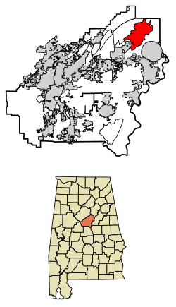
Location of Sterrett in Shelby County, Alabama.
USA Alabama location map.svg
Red pog.svg
Sterrett, Alabama
Coordinates: 33°26′55″N86°28′48″W / 33.44861°N 86.48000°W / 33.44861; -86.48000
Country United States
State Alabama
County Shelby
Area
[1]
  Total23.57 sq mi (61.05 km2)
  Land22.92 sq mi (59.37 km2)
  Water0.65 sq mi (1.68 km2)
Elevation
518 ft (158 m)
Population
 (2020)
  Total706
  Density30.80/sq mi (11.89/km2)
Time zone UTC-6 (Central (CST))
  Summer (DST) UTC-5 (CDT)
ZIP code
35147
Area code(s) 205, 659
GNIS feature ID127366 [2]

Sterrett is a census-designated place and unincorporated community in Shelby County, Alabama, United States. Its population was 712 as of the 2010 census. [3]

Contents

History

Sterrett was named in honor of a prominent local family, which included Alphonso A. Sterrett, who served in the Alabama Legislature. [4] At one point in its history, Sterrett was a center of pottery production in central Alabama. Also known as Jugtown, Sterrett was once home to at least ten potters. [5] The pottery produced here was classified as being part of the East Alabama style of pottery, which used high quality clay and a two-toned glaze decoration. [6] William Hilliard Falkner purchased the Sterrett Pottery Works in 1874 and operated it until 1903. His father, Joel Falkner, was also a potter in Sterrett. [7]

Sterrett was once home to Twin Pines Conference Center, which was founded by Robert "Bob" Saunders. The Bob Saunders Family Covered Bridge is located on the property of the former conference center and is listed in the World Guide to Covered Bridges. [8]

Geography

The community is in the northeastern part of Shelby County. Alabama State Route 25 runs through the community, leading southeast 7 mi (11 km) to Vincent and northwest 13 mi (21 km) on a particularly winding and mountainous route to the city of Leeds.

Demographics

Historical population
CensusPop.Note
2020 706
U.S. Decennial Census [9]

Related Research Articles

<span class="mw-page-title-main">Blount County, Alabama</span> County in Alabama, United States

Blount County is a county located in the U.S. state of Alabama. As of the 2020 census, the population was 59,134. Its county seat is Oneonta.

<span class="mw-page-title-main">Shelby County, Alabama</span> County in Alabama, United States

Shelby County is located in the central portion of the U.S. state of Alabama. As of the 2020 census the population was 223,024, making it the sixth-most populous county in Alabama. The county seat is Columbiana. Its largest city is Alabaster. The county is named in honor of Isaac Shelby, Governor of Kentucky from 1792 to 1796 and again from 1812 to 1816. Shelby County is included in the Birmingham–Hoover, AL Metropolitan Statistical Area.

<span class="mw-page-title-main">Talladega County, Alabama</span> County in Alabama, United States

Talladega County is one of the sixty-seven counties located in the east central portion of the U.S. state of Alabama. As of the 2020 census, the population was 82,149. Its county seat is Talladega.

<span class="mw-page-title-main">Saunders County, Nebraska</span> County in Nebraska, United States

Saunders County is a county in the U.S. state of Nebraska. As of the 2020 United States Census, the population was 22,278. Its county seat is Wahoo.

<span class="mw-page-title-main">Hoover, Alabama</span> City in Alabama, United States

Hoover is a city in the Jefferson and Shelby counties in north central Alabama, United States. Hoover is the largest suburban city in Alabama and the 6th largest city in Alabama. The population was 92,606 at the 2020 census. Hoover is part of the Birmingham, AL Metropolitan Statistical Area and is also included in the Birmingham-Cullman-Talladega, AL Combined Statistical Area. Hoover's territory is along the foothills of the Appalachian Mountains.

<span class="mw-page-title-main">Columbiana, Alabama</span> City in and county seat of Shelby County, Alabama

Columbiana is a city and the county seat of Shelby County, Alabama, United States. At the 2020 census, the population was 4,462.

<span class="mw-page-title-main">Montevallo, Alabama</span> City in Alabama, United States

Montevallo is a city in Shelby County, Alabama, United States. A college town, it is the home of the University of Montevallo, a public liberal arts university with approximately 3,000 students. As of the 2020 census, the population of the city of Montevallo is 7,229.

<span class="mw-page-title-main">Vincent, Alabama</span> City in Alabama, United States

Vincent, originally known as Propel, is a city in Shelby, St. Clair, and Talladega counties in the U.S. state of Alabama. At the 2020 census, the population was 1,982. The community was first known as Propel, but later named Vincent in honor of the Vincent family, who were early settlers of the area. It was incorporated in 1897.

<span class="mw-page-title-main">Santa Clara Pueblo, New Mexico</span> CDP in New Mexico, United States

Santa Clara Pueblo "Singing Water Village", also known as "Village of Wild Roses" is a census-designated place (CDP) in Rio Arriba County, New Mexico, United States and a federally recognized tribe of Native American Pueblo people.

<span class="mw-page-title-main">Waxahachie, Texas</span> City in Texas, United States

Waxahachie is the county seat of Ellis County, Texas, United States. Its population was 41,140 in 2020. The city was founded in 1850, and incorporated in 1871. Much of the employment is provided by a number of industries and by educational institutions, including primary and secondary schools, a community college and a private university. In the mid-80's it became a filming location for a number of movies and occasional episodes of television series.

<span class="mw-page-title-main">Sautee Nacoochee, Georgia</span> Place in Georgia, United States

Sautee Nacoochee is an unincorporated community and census-designated place in White County, Georgia, United States, near Sautee Creek in the Appalachian foothills of northeast Georgia, approximately 95 miles (153 km) north of Atlanta. The nearest incorporated town is the tourist destination of Helen.

Jefferson State Community College is a public community college with multiple campuses in Alabama, including the Jefferson Campus in northeastern Birmingham, Alabama, the Shelby-Hoover Campus in northern Shelby County, the St. Clair-Pell City Campus in Pell City, and the Chilton-Clanton Campus in Clanton. It is the largest college in the Alabama Community College System.

<span class="mw-page-title-main">Memphis metropolitan area</span> Combined statistical area in the United States

The Memphis–Clarksdale-Forrest City Combined Statistical Area, TN–MS–AR (CSA) is the commercial and cultural hub of the Mid-South or Ark-Miss-Tenn. The census-defined combined statistical area covers eleven counties in three states, Tennessee, Mississippi, and Arkansas. As of 2020 census, the Memphis metropolitan area had a population of 1,389,905 The Forrest City, Arkansas Micropolitan area was added to the Memphis area in 2012 to form the Memphis–Forrest City Combined Statistical area. In 2023 the Clarksdale, Mississippi Micropolitan area was also added to form the new Memphis-Clarksdale-Forrest City Combined Statistical Area which as of 2023 had a population of roughly 1.4 million people according to census estimates.

<span class="mw-page-title-main">Westover, Alabama</span> City in Alabama, United States

Westover is a city in Shelby County, Alabama, United States. The city is part of the Birmingham Metropolitan Statistical Area. The city was officially incorporated on January 31, 2001, although it was established in 1901 and had a population of 961 when it was incorporated in 2001.

Berlin is a town in Cullman County, Alabama, United States. The population was 476 at the 2020 census. It is located roughly five miles east of the city of Cullman in northern Alabama. U.S. Route 278 and Cullman County Road 747 intersect at Walker's Corner, considered to be the center of Berlin. The Berlin Community Center is located on U.S. Route 278, just west of the crossroads.

<span class="mw-page-title-main">Vandiver, Alabama</span> Census-designated place & Unincorporated community in Alabama, United States

Vandiver is a census-designated place (CDP) and unincorporated community in Shelby County, Alabama, United States. Its population was 1,084 as of the 2020 census. One structure in Vandiver, the Falkner School, is listed on the Alabama Register of Landmarks and Heritage.

<span class="mw-page-title-main">Dunnavant, Alabama</span> Census-designated place in Alabama, United States

Dunnavant, also spelled Dunavant, is a census-designated place and unincorporated community in Shelby County, Alabama, United States. Its population was 981 as of the 2010 census. The community's name is probably derived from a local family. A post office was established in 1897 and was in operation until it was closed in 1958.

<span class="mw-page-title-main">Shelby, Alabama</span> Census-designated place in Alabama, United States

Shelby is a census-designated place and unincorporated community in Shelby County, Alabama, United States. Its population was 1,044 as of the 2010 census. The area is near Lay Lake and Waxahatchee Creek. Shelby Iron Park is located at the heart of the area. Two sites in Shelby, The Brick House and the Old Shelby Hotel, are listed on the Alabama Register of Landmarks and Heritage.

Pea Ridge is a census-designated place in Shelby County, Alabama, United States. The community is named for Pea Ridge, the broadest ridge in the Cahaba Coal Field. This ridge divides the waters of the Cahaba River and Little Cahaba River. Pea Ridge has maintained a volunteer fire department since 1972.

Acton is an unincorporated community in Jefferson County, in the U.S. state of Alabama. It is a suburban area bordering the city of Birmingham, centered around the intersection of Caldwell Mill Road and Old Looney Mill Road just west of the Cahaba River. It is not to be confused with the former mining village of Acton, Alabama in Shelby County (now within the city of Hoover, approximately 6+12 miles to the southwest as the crow flies. Initially, this Acton was also in Shelby County before a border adjustment shifted it into Jefferson County.

References

  1. "2020 U.S. Gazetteer Files". United States Census Bureau. Retrieved October 29, 2021.
  2. "Sterrett". Geographic Names Information System . United States Geological Survey, United States Department of the Interior.
  3. "U.S. Census website". United States Census Bureau . Retrieved May 14, 2011.
  4. Foscue, Virginia (1989). Place Names in Alabama. Tuscaloosa: The University of Alabama Press. p. 132. ISBN   0-8173-0410-X.
  5. Gaffney, Dennis (January 16, 2012). "Alabama Stoneware — A Jug-full of History | Follow the Stories | Antiques Roadshow". PBS. Retrieved June 30, 2014.
  6. Salzman, Jack (May 25, 1990). American Studies: An Annotated Bibliography - Jack Salzman - Google Books. ISBN   9780521365598 . Retrieved June 29, 2014.
  7. Dubose, Joel Campbell (1904). Notable Men of Alabama: Personal and Genealogical, Volume 1 - Joel Campbell DuBose - Google Books . Retrieved June 29, 2014.
  8. "Saunders Covered Bridge". Shelby County Tourism. January 16, 2012. Retrieved November 10, 2014.
  9. "Census of Population and Housing". Census.gov. Retrieved June 4, 2016.