McFarland, Wisconsin | |
---|---|
Coordinates: 43°1′7″N89°17′28″W / 43.01861°N 89.29111°W | |
Country | United States |
State | Wisconsin |
County | Dane |
Government | |
• Village President | Carolyn Clow |
Area | |
• Total | 4.77 sq mi (12.34 km2) |
• Land | 4.76 sq mi (12.33 km2) |
• Water | 0.01 sq mi (0.02 km2) |
Elevation | 869 ft (265 m) |
Population (2021) [4] | |
• Total | 9,325 |
• Density | 1,897.67/sq mi (732.64/km2) |
Time zone | UTC-6 (Central (CST)) |
• Summer (DST) | UTC-5 (CDT) |
Area code | 608 |
FIPS code | 55-46850 [5] |
GNIS feature ID | 1569214 [3] |
Website | mcfarland |
McFarland is a village in Dane County, Wisconsin, situated on the shores of Lake Waubesa to the southeast of Madison. As of the 2020 U.S. Census, the village has a population of 9,325. [6] Spanning just under five square miles and encompassing roughly 43.50 miles of roads, it is part of the Madison Metropolitan Statistical Area.
In McFarland, U.S. Route 51 serves as the primary artery linking the town to the cities of Madison and Stoughton. The postal code is 53558. It is the tenth most populous place in Dane County. [6]
The Village of McFarland has several burial mounds from the Woodland period, collectively known as the Lewis Mound Group, located within Indian Mound Park. [7]
Established in 1856 by William Hugh McFarland, the village's early industries included wheat and tobacco farming, ice and fish harvesting from the nearby Lake Waubesa for rail transportation to Chicago markets. A modest resort industry eventually emerged along the eastern shore of Lake Waubesa, featuring attractions such as Edwards Park and Larson's Beach. Following World War II, McFarland evolved into a residential community for Madison. In the late 1950s, the village annexed the newly-built petroleum tank farms to the north, bolstering its tax base and enabling the McFarland School District to finance a new high school. Commuting from McFarland became significantly more convenient in 1989 with the completion of a major highway project on the adjacent Madison Beltline, sparking rapid residential growth. [8]
McFarland is located at 43°1′7″N89°17′28″W / 43.01861°N 89.29111°W (43.018480, -89.291116). [9]
According to the United States Census Bureau, the village has a total area of 3.55 square miles (9.19 km2), all of its land. It is bordered by Lake Waubesa to the west and Mud Lake to the south. [10]
As in the rest of the state of Wisconsin, McFarland is located in the Central Time Zone.
Census | Pop. | Note | %± |
---|---|---|---|
1880 | 168 | — | |
1890 | 166 | −1.2% | |
1930 | 313 | — | |
1940 | 463 | 47.9% | |
1950 | 593 | 28.1% | |
1960 | 1,272 | 114.5% | |
1970 | 2,386 | 87.6% | |
1980 | 3,783 | 58.5% | |
1990 | 5,232 | 38.3% | |
2000 | 6,416 | 22.6% | |
2010 | 7,808 | 21.7% | |
2020 | 8,991 | 15.2% | |
U.S. Decennial Census [11] |
As of the census [4] of 2010, there were 7,808 people, 3,079 households, and 2,201 families residing in the village. The population density was 2,199.4 inhabitants per square mile (849.2/km2). There were 3,200 housing units at an average density of 901.4 per square mile (348.0/km2). The racial makeup of the village was 94.4% White, 1.2% African American, 0.4% Native American, 1.7% Asian, 0.1% Pacific Islander, 0.7% from other races, and 1.5% from two or more races. Hispanic or Latino of any race were 2.3% of the population.
There were 3,079 households, of which 38.8% had children under the age of 18 living with them, 56.9% were married couples living together, 10.1% had a female householder with no husband present, 4.4% had a male householder with no wife present, and 28.5% were non-families. Of all households, 21.9% were made up of individuals, and 7.8% had someone living alone who was 65 years of age or older. The average household size was 2.54 and the average family size was 2.96.
The median age in the village was 39.7 years. 26.9% of residents were under the age of 18; 5.6% were between the ages of 18 and 24; 26% were from 25 to 44; 31.2% were from 45 to 64; and 10.3% were 65 years of age or older. The gender makeup of the village was 49.0% male and 51.0% female.
The McFarland School District serves the village of McFarland. [12] It operates Conrad Elvehjem Early Learning Center (K), McFarland Primary School (grades 1–2), Waubesa Intermediate School (3–5), Indian Mound Middle School (6–8) and McFarland High School, which is accredited by the AdvancED commission.
The McFarland School District has consistently scored above the state average on standardized tests. [13] In addition, the district has received a number of accolades and awards for its educational programs and initiatives. [14]
McFarland is governed by a village board consisting of a president and six trustees. [15] The president and trustees are elected to two-year terms during spring elections. The Village President of McFarland is Carolyn Clow. [16]
McFarland has a full-time village administrator, who is responsible for the administration of the village government in accordance with the policies established by the Village Board. Other city officers consist of Village Clerk, treasurer, municipal judge, police chief and fire chief.
Summer Concert Series
The village hosts a summer concert series in McDaniel Park, featuring live music from local and regional bands. [17]
Farmers Market
The McFarland Farmers' Market is held on Saturday mornings from May through October at the McFarland Village Center. The market features fresh produce, baked goods, crafts, and other items from local vendors. [18]
McFarland Community Festival
Since 1985 McFarland has held a festival on the fourth weekend every September. The festival has carnival rides, train rides, a parade, and many competitions. [19]
Winter Wonderland in the Village
In the first week of December, Winter Wonderland in the Village (formerly known as Christmas in the Village) takes place. Among the events are Open Houses, Scavenger Hunts, Carriage Rides, Santa visits, and a parade. [20]
Located just south of US 12, Madison's "Beltline Highway," McFarland is four minutes from Interstate 90, 12 minutes from the Wisconsin State Capitol, and 12 minutes from the University of Wisconsin.
McFarland is served by the Dane County Regional Airport, which is located 12 miles north of the village. McFarland is served by two taxicab companies (Union Taxi and Madison Taxi), as well as several companies that provide specialized transportation for persons with disabilities. Additionally, Uber and Lyft are available in McFarland.
The village is crossed by the Wisconsin and Southern railroad line.
McFarland offers several biking trails, including the Lower Yahara River Trail. The approximately 2.5 miles of this trail link Madison, WI to McFarland, WI via an off-road trail sysystem. Among its features is North America's longest inland boardwalk bridge.
The far northern end of the village is served by Metro Transit Route L along Meinders Road, which connects Madison's Owl Creek neighborhood to the rest of the East Side of Madison.
McFarland's community fire department, known as McFarland Fire Rescue, serves an extensive region of 14 square miles, encompassing both the village and nearby towns. The department offers comprehensive firefighting and Paramedic services. Established in 1908, McFarland Fire Rescue now comprises 68 paid-on-call personnel who maintain external employment and an additional nine full-time staff members.
The Village has a full-service Police Department, that provides law enforcement services 24 hours a day. The McFarland Police Department is staffed by a Chief, Lieutenant, 3 Sergeants, Detective, Investigator, and 10 Officers as well as 2 non-sworn administrative staff. [22] The McFarland Police Department has an extensive outreach program, School Resource Officer, Community Service Officer, and K-9 Officer.
The E.D. Locke Public Library serves the village. It is part of the South Central Library System. Services include youth programming, adult programming, reference, database, technical services, and circulation.
McFarland enjoys comprehensive media coverage from various Madison-based television, radio, print, and digital outlets. The community is kept informed through its local weekly newspaper, the McFarland Thistle. Additionally, McFarland residents have access to a local public-access television channel, WMCF.
The McFarland School District and US Oil are two of the most significant employers in the village. Many residents commute to jobs in Madison.
McFarland Historical Museum
The McFarland Historical Museum is maintained by members of the McFarland Historical Society, which is dedicated to preserving and promoting the history and heritage of the Village of McFarland. Each Sunday from Memorial Day to September, the Museum and Log Cabin are open to the public from 1:00 p.m. to 4:00 p.m. [8]
Larson House Museum
The Larson House is a restored Queen Anne style Victorian home built in 1898 by E.N. Edwards. The home is open for tours on Sunday afternoons from 1 to 4 pm, Memorial Day to Labor Day. [23]
McFarland Community Ice Arena
The McFarland Community Ice Arena is operated by a private non-profit and hosts McFarland Youth Hockey, McFarland high school hockey, and a variety of other groups. [24]
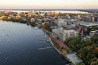
Madison is the capital city of the U.S. state of Wisconsin and the county seat of Dane County. As of the 2020 census, the population was 269,840, making it the second-most populous city in Wisconsin after Milwaukee, and the 80th-most populous in the United States. The Madison metropolitan area had a population of 680,796. The city is located on an isthmus and lands surrounding five lakes—Lake Mendota, Lake Monona, Lake Wingra, Lake Kegonsa and Lake Waubesa. Madison was founded in 1836 and is named after American Founding Father and President James Madison.
Walworth County is a county located in the U.S. state of Wisconsin. As of the 2020 census, the population was 106,478. Its county seat is Elkhorn. The county was created in 1836 from Wisconsin Territory and organized in 1839. It is named for Reuben H. Walworth. Walworth County comprises the Whitewater-Elkhorn, WI Micropolitan Statistical Area and is included in the Milwaukee-Racine-Waukesha, WI Combined Statistical Area. Lake Geneva, the University of Wisconsin-Whitewater, and Alpine Valley Resort, and Music Theatre are located in Walworth County.
Rock County is a county in the U.S. state of Wisconsin. As of the 2020 census, the population was 163,687. Its county seat is Janesville. Rock County comprises the Janesville-Beloit, WI Metropolitan Statistical Area and is included in the Madison-Janesville-Beloit, WI Combined Statistical Area.
Milwaukee County is located in the U.S. state of Wisconsin. At the 2020 census, the population was 939,489, down from 947,735 in 2010. It is both the most populous and most densely populated county in Wisconsin, and the 45th most populous county nationwide; Milwaukee, its eponymous county seat, is also the most populous city in the state. The county was created in 1834 as part of Michigan Territory and organized the following year.
Jefferson County is a county in the U.S. state of Wisconsin. As of the 2020 census, the population was 84,900. Its county seat is Jefferson. Jefferson County comprises the Watertown-Fort Atkinson, WI Micropolitan Statistical Area, which is also included in the Milwaukee-Racine-Waukesha, WI Combined Statistical Area.
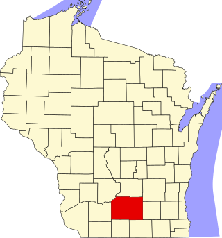
Dane County is a county in the U.S. state of Wisconsin. As of the 2020 census, the population was 561,504, making it the second-most populous county in Wisconsin after Milwaukee County. The county seat is Madison, which is also the state capital. Dane County is the central county of the Madison, Wisconsin, Metropolitan Statistical Area, as well as the Madison-Janesville-Beloit Combined Statistical Area.
Madison County is a county in the U.S. state of Illinois. It is a part of the Metro East in southern Illinois. According to the 2020 census, it had a population of 264,776, making it the eighth-most populous county in Illinois and the most populous in the southern portion of the state. The county seat is Edwardsville, and the largest city is Granite City.
Stevens Point is a city in and the county seat of Portage County, Wisconsin, United States. Its population was 25,666 as of the 2020 census. It forms the core of the Stevens Point micropolitan statistical area, which had a population of 70,377 in 2020.
Grand Mound is a community and census-designated place (CDP) in Thurston County, Washington, United States. It was named and founded by Jotham Weeks Goodell, father of Phoebe Judson, in 1851. The population was 3,301 at the 2020 census. This area uses the 98579 and 98531 zip codes, which also includes Rochester and Gate.
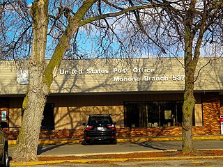
Monona is a city in Dane County, Wisconsin, United States. A suburb of the state capital, Madison, the city lies on the southeastern shore of Lake Monona, from which the city gets its name. The population was 8,624 at the 2020 census.
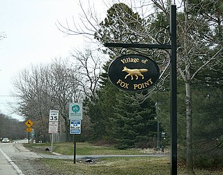
Fox Point is a village in Milwaukee County, Wisconsin, United States. The population was 6,934 at the 2020 census.
Blanchardville is a village in Iowa and Lafayette counties in the U.S. state of Wisconsin. The population was 825 at the 2010 census. Of this, 648 were in Lafayette County, and 177 were in Iowa County.
New London is a city in Outagamie and Waupaca counties Wisconsin, United States. Founded in 1851, the population was 7,295 at the 2010 census. Of this, 5,685 were in Waupaca County, and 1,640 were in Outagamie County.
Middleton is a city in Dane County, Wisconsin, United States, and a suburb of the state capital, Madison. Middleton's motto is "The Good Neighbor City." The population was 21,827 at the 2020 census.
Oregon is a village in Dane County, Wisconsin. As of the census of 2020, the population was 11,179. Oregon is part of the Madison Metropolitan Statistical Area. The village is located mostly within the Town of Oregon.
Cedarburg is a city in Ozaukee County, Wisconsin, United States. Located about 20 miles (32 km) north of Milwaukee and in close proximity to Interstate 43, it is a suburban community in the Milwaukee metropolitan area. The city incorporated in 1885, and at the time of the 2020 census the population was 12,121.
This is a list of the National Register of Historic Places listings in Dane County, Wisconsin. It aims to provide a comprehensive listing of buildings, sites, structures, districts, and objects in Dane County, Wisconsin listed on the National Register of Historic Places.
McFarland School District (MMSD) is a public school district headquartered in McFarland, Wisconsin. It serves the Village of McFarland, City of Madison, the towns of Dunn, Cottage Grove, and Pleasant Springs.
The Madison Metropolitan School District (MMSD) is a public school district headquartered in Madison, Wisconsin. It serves the cities of Madison and Fitchburg, the villages of Shorewood Hills and Maple Bluff, and the towns of Blooming Grove and Burke.
The Lewis Mound Group (47-Da-74) is a set of prehistoric Native American burial mounds in the village of McFarland, Dane County, Wisconsin, southeast of Madison. Created by late Woodland people overlooking the eastern shore of Lake Waubesa, they include a bear effigy, a hook-shaped mound, and some geometric shapes. They are visible from public trails in Indian Mound Park, which is owned by the village, just west of Indian Mound Middle School. The site was listed on the National Register of Historic Places in 1984.