
U6 is a Berlin U-Bahn line, 19.9 km (12.4 mi) long line with 29 stations. It runs in a north-south direction from the Berlin locality of Tegel in the north via Friedrichstraße to Mariendorf, a locality in the southern part of the city. It is a so-called large profile ("Großprofil") line.
The U7 is a rail line on the Berlin U-Bahn. It runs completely underground for a length of 31.8 kilometres (19.8 mi) through 40 stations and connects Spandau, via Neukölln, to Gropiusstadt and Rudow. The line was originally the south-eastern branch of the Nord-Süd-Bahn (U6) that ran between the branching point at Belle-Alliance-Straße (Mehringdamm) and Grenzallee; however, in the 1960s, this stretch was separated from the rest of the line and extended at each end to form a new line. As of 2007, the U7 is Berlin's longest underground line, both in terms of absolute length and total travel time, and one of the longest (entire) subterranean lines in Europe.

Warschauer Straße station is an S-Bahn and U-Bahn station on Warschauer Straße on the northern bank of the river Spree in the Friedrichshain neighborhood of Berlin, Germany. The two train stations as well as the trams that terminate adjacent to the U-Bahn station together accommodate over 85,000 passengers daily.
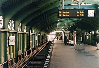
Eberswalder Straße is an overground station located on the line of the Berlin U-Bahn network. It is located in the Prenzlauer Berg area of the city on Schönhauser Allee, a major street running from the city centre north towards Pankow.

Weberwiese is a Berlin U-Bahn station located on the line, which currently runs from Berlin Central Station to Hönow. The station is located under Karl-Marx-Allee directly east of Straße der Pariser Kommune. Although the next station on the line is called Frankfurter Tor, the historical city gate Frankfurter Tor actually stood at the location of the Weberwiese station. Several of the stations on this line have been recently redeveloped and are now colour-coded. In 2003, Weberwiese station was renovated and now has a very different appearance, with yellow tiles in contrast to its former white ones.

Gneisenaustraße is a station on the in Berlin, Germany.

Louis-Lewin-Straße is a surface level Berlin U-Bahn station in the German capital city of Berlin. It is part of the Berlin U-Bahn; the station is located on the line.

Holzhauser Straße is a Berlin U-Bahn station located on the line. The station was built on an embankment by Grimmek in 1958.
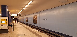
Afrikanische Straße is a station in the Wedding district of Berlin which serves the line and is operated by the BVG. The station is located under the Müllerstraße, one of the district's major shopping streets and thoroughfares, but named for another major street nearby. The BVG uses the station under the internal abbreviation Afr; the train station is 631 meters from the Kurt-Schumacher-Platz U-Bahn Station and 587 meters from the Rehberge U-Bahn Station.

Naturkundemuseum, formerly Zinnowitzer Straße, is a Berlin U-Bahn station located on the in the district Mitte.

Französische Straße was a Berlin U-Bahn underground station on the line located under the street Friedrichstraße in central Berlin.

Platz der Luftbrücke is a Berlin U-Bahn station located on the . It is located under Platz der Luftbrücke and the south end of Mehringdamm on the border between Kreuzberg and Tempelhof, near the former Tempelhof International Airport, and is now named for the square there with its memorial to the victims of the Berlin Airlift.

Tempelhof is a railway station in the district of Berlin with the same name. It is served by the S-Bahn lines , , and and the U-Bahn line . The S-Bahn station is on an embankment at the junction of Tempelhofer Damm and Bundesautobahn 100, about 1 km south of the entrance to the former Tempelhof Airport. The U-Bahn station, officially called Tempelhof (Südring), is under Tempelhofer Damm immediately south of the S-Bahn station.

Kaiserin-Augusta-Straße is a Berlin U-Bahn station located on the . Opened in 1966 by R. G. Rümmler, it has direct access to a department store.

Wilmersdorfer Straße is a Berlin U-Bahn station located on the line.

Konstanzer Straße is a Berlin U-Bahn station located on line in the Wilmersdorf district.

Eisenacher Straße is a Berlin U-Bahn station located on the . R.G. Rümmler constructed this station which was opened 1971. The wall is covered with green asbestos cement panels. Since Eisenach is a city near the forest in Thuringia, which is called the green heart of Germany, Rümmler chose green as the color of this station. The next station is Kleistpark.

Osloer Straße is a Berlin U-Bahn station in the Gesundbrunnen district, located on the and . Like the eponymous street it is named after the City of Oslo.

Bernauer Straße is a Berlin U-Bahn station located on the .

The Mehringdamm is a street in southern Kreuzberg, Berlin. In the north it starts at Mehringbrücke and ends - with its southernmost houses already belonging to Tempelhof locality - on Platz der Luftbrücke. It is the historical southbound Berlin-Halle highway, now forming the federal route 96. The main junction of Mehringdamm is with the 19th-century ring road around Berlin's inner city, named Yorckstraße west, and Gneisenaustraße east of Mehringdamm.


