
Rathaus Spandau is one of the western termini of Berlin U-Bahn line U7. It was opened on 1 October 1984 with the line's extension from Rohrdamm to Rathaus Spandau. The station takes its name from the nearby Rathaus Spandau, the historic city hall of Spandau.

U3 is a line on the Berlin U-Bahn created in its current version on 7 May 2018.
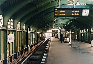
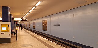
Eberswalder Straße is an overground station located on the line of the Berlin U-Bahn network. It is located in the Prenzlauer Berg area of the city on Schönhauser Allee, a major street running from the city centre north towards Pankow.
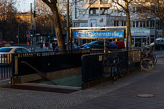
Spichernstraße is a Berlin U-Bahn station located on the and the lines, located in Wilmersdorf neighbourhood. The U3 portion opened on 2 June 1959, replacing the nearby Nürnberger Platz station, which was closed and dismantled. The U9 portion, which lies deeper underground, opened on 28 August 1961 as the southern terminus of the new line, then called G. The eponymous street is named after Spicheren in Lorraine, France, site of the 1870 Battle of Spicheren.
Rüdesheimer Platz is a Berlin U-Bahn station located in the Wilmersdorf district on the line.
Freie Universität (Thielplatz) is a Berlin U-Bahn station located in the Dahlem district on the . It is one of two main stations to reach the nearby Freie Universität Berlin and the Fritz Haber Institute of the Max Planck Society. It was opened on 12 October 1913 and until 1929 was the southwestern terminus of the line. In 1980, a second entrance was built. In December 2016 the station was renamed from "Thielplatz" to "Freie Universität (Thielplatz)"

Onkel Toms Hütte is a Berlin U-Bahn station located in the Zehlendorf district. Since 12 December 2004 it is served by the line.

Krumme Lanke, literally “Crooked Lake“, is a Berlin U-Bahn station on the . It is the line's southwestern terminus, located in the Zehlendorf district of Berlin.

Samariterstraße is a Berlin U-Bahn station located on the . It is located underneath Frankfurter Allee, at the intersection with Samariterstraße in the district of Friedrichshain. It was opened as part of the then-extant Line E of the Berlin U-Bahn on 21 December 1930. As the station remains almost in its original condition, it is now protected as a historic building.

Alt-Tegel is a Berlin U-Bahn station located on the . It was constructed by B. Grimmek and opened as "Tegel" station in 1958. In 1992, the station was renamed to Alt-Tegel. Nearby, indeed nearly 600 meters to walk, is the S-Bahn station Berlin-Tegel, and the rename perhaps occurred to avoid confusion.
Afrikanische Straße is a station in the Wedding district of Berlin which serves the line and is operated by the BVG. The station is located under the Müllerstraße, one of the district's major shopping streets and thoroughfares, but named for another major street nearby. The BVG uses the station under the internal abbreviation Afr; the train station is 631 meters from the Kurt-Schumacher-Platz U-Bahn Station and 587 meters from the Rehberge U-Bahn Station.
Alt-Tempelhof is a Berlin U-Bahn station on the . It is located under Tempelhofer Damm in the centre of the former village of Tempelhof, now a Berlin district within the borough of Tempelhof-Schöneberg. The station opened on 28 February 1966.

Grenzallee is a Berlin U-Bahn station located on the U7.

Berlin-Wittenau (in German S-Bahnhof Berlin-Wittenau, officially Wittenau (Wilhelmsruher Damm)) is a railway station in the Wittenau district of Berlin, Germany. It is served by the Berlin S-Bahn and numerous local buses. It is also the northern terminus of the Berlin U-Bahn line .

Bernauer Straße is a Berlin U-Bahn station located on the .

Leinestraße is a Berlin U-Bahn station located on the line.

Berlin Westhafen is a station in the Moabit district of Berlin. It is served by the S-Bahn lines and and the U-Bahn line .

Dahlem is a locality of the Steglitz-Zehlendorf borough in southwestern Berlin. Until Berlin's 2001 administrative reform it was a part of the former borough of Zehlendorf. It is located between the mansion settlements of Grunewald and Lichterfelde West.

Berlin-Charlottenburg is a railway station in the Charlottenburg district of Berlin. The station is located on the Stadtbahn line, served by the , , , and lines of the Berlin S-Bahn, as well as by Regional-Express and Regionalbahn trains operated by Deutsche Bahn. The U-Bahn station Wilmersdorfer Straße (U7) can be reached via short footpath.

Berlin Brandenburger Tor – formerly Berlin Unter den Linden (1936-2009) – is an underground railway station in the central Mitte district of Berlin, Germany, located on the Unter den Linden boulevard near Hotel Adlon, Pariser Platz and Brandenburg Gate. It is served by the Berlin S-Bahn and U-Bahn, as well as local bus lines.

