Related Research Articles
Saint Mary, officially the Parish of Saint Mary, is a parish of Antigua and Barbuda on the island of Antigua. Saint Mary borders Saint John to the north, and Saint Paul to the east. Saint Mary is dominated by the Shekerley Mountains, and its northern border is largely defined by the mountains, and by Cooks Creek. The largest city in the parish is Bolans, home to the Jolly Harbour neighbourhood, and the parish church is located in Old Road. Saint Mary was created with the other five original parishes on 11 January 1692. It had a population of 7,341 in 2011, and 8,141 in 2018.

Saint Paul, officially the Parish of Saint Paul, is a parish of Antigua and Barbuda on the island of Antigua. Saint Paul borders Saint Peter and Saint John to the north, Saint Mary to the west, and Saint Philip to the east. Saint Paul is dominated by farmland in the north, with various creeks and Potworks Dam marking its northern border, and low-lying hills to the south, defining its western border with Saint Mary. The largest city fully within the parish is Liberta, the fourth largest city in the country. The parish capital, and the location of the parish church, is Falmouth. The main economic and tourism hub of the parish is English Harbour. Saint Paul was created with the other five original parishes on 11 January 1692. It had a population of 9,004 in 2018.

Saint Peter, officially the Parish of Saint Peter, is a parish of Antigua and Barbuda on the island of Antigua. Saint Peter borders Saint Paul to the south, Saint Philip to the east, and Saint George and Saint John to the west. Saint Peter is dominated by farmland, savanna, and undeveloped fields, and its borders are not well-defined. The largest city fully within the parish is Parham, which is also the capital. However, the portion of the city of All Saints in Saint Peter is significantly larger than Parham. Saint Peter was created with the other five original parishes on 11 January 1692. It had a population of 5,325 in 2011.

All Saints is the second largest town in Antigua and Barbuda, with a population of 3,412. It is located in the middle of Antigua, at 17°3′N61°47′W. Just 5 miles NW of here is the capital, St. John's. It had a population of 3,900 in 2001.

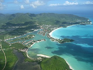
Parham, officially known as Parham Town, is the capital of Saint Peter, the largest city in Saint Peter, and the fourteenth largest city in Antigua and Barbuda. Parham had a population of 1,307 in 2011, distributed over 1.99 square kilometres. Parham is similar in population to Potters Village, the thirteenth largest city in Antigua and Barbuda, and Bendals, the fifteenth largest city. Parham is situated on the shore of Parham Harbour, one of the most important harbors in the country enclosed by the Parham Peninsula and Long Island. Parham comprises four main neighbourhoods: Lovers Lane, Parham Market, Byam Wharf, and the School neighborhood. If the Saint Peter portion of All Saints, home to 1,954 people extending across three parishes, is considered a separate city, Parham would be considered the second largest city of Saint Peter. The major division of Parham, the town's metropolitan area, stretching over the eastern portion of the parish, had a 2011 population of 3,499 people.
Freetown, officially known as FreeTown, is a town in Antigua. It is located in the southeast of the island, on a peninsula between Willoughby Bay to the south and Nonsuch Bay to the north.

Urlings is a village in Saint Mary, and the twenty-sixth largest settlement in Antigua and Barbuda. Urlings is located in the southwest of Antigua and has a history dating to before 1856. Urlings started as a small coastal village with a little over 100 people in the 1800s to now being one of the country's more medium sized towns. Urlings is separated from the rest of Antigua by the Shekerley Mountains. Urlings is located between the communities of Johnsons Point and Old Road. Urlings has a seafood festival, a community association, a primary school, a playing field, a fisheries complex, and a cricket club that plays in the Village Parish League.

Barbuda North is a village and enumeration district on the island of Barbuda.
Barbuda-South or Barbuda South River Road, is a village and enumeration district on the island of Barbuda.
Golden Grove is a village in Saint John Parish, Antigua and Barbuda.

Clarkes Hill is a town in Saint John Parish, Antigua and Barbuda.

Multiracial Antiguans and Barbudans are Antiguans and Barbudans of more than one race or ethnicity.
Barbuda-East is a village and enumeration district on the island of Barbuda.
Downtown, officially City Center Downtown, is an enumeration district in the Major Division of Upper Fort Road, St. John's, Antigua and Barbuda.
Twenty Hill is a historic site and sparsely populated unincorporated area in southern Parham.
Montclear is a major city in All Saints Northwest, Saint John, Antigua and Barbuda. It had a population of 1,246 in the 2011 census. It has an area of 0.7 square kilometres.
On the island of Barbuda, which is part of the nation of Antigua and Barbuda, the housing industry is a major economic sector. The majority of households, or 68.38% of all households, are owner-occupied homes.

Long Bay is a coastal settlement in Saint Philip, Antigua and Barbuda.
Herberts is a major town in Saint John, Antigua and Barbuda.
References
- ↑ http://laws.gov.ag/wp-content/uploads/2018/08/cap-466.pdf [ bare URL PDF ]
- ↑ "The political Neanderthal". 12 March 2020.
- ↑ "Montpelier populated place, Saint Philip, Antigua and Barbuda".
- ↑ "Montpelier – Antigua Sugar Mills" . Retrieved 2023-01-22.
- ↑ "2001 Census" (PDF).
- 1 2 (PDF). 2023-01-22 https://web.archive.org/web/20230122173739/https://redatam.org/binatg/RpWebUtilities.exe/reporte.pdf?LFN=RpBases%5CTempo%5C54575%5C~tmp_5457501.pdf. Archived from the original (PDF) on 2023-01-22. Retrieved 2023-01-22.
{{cite web}}: Missing or empty|title=(help) - ↑ (PDF). 2023-01-22 https://web.archive.org/web/20230122174207/https://redatam.org/binatg/RpWebUtilities.exe/reporte.pdf?LFN=RpBases%5CTempo%5C54575%5C~tmp_5457561.pdf. Archived from the original (PDF) on 2023-01-22. Retrieved 2023-01-22.
{{cite web}}: Missing or empty|title=(help) - ↑ (PDF). 2023-01-22 https://web.archive.org/web/20230122174424/https://redatam.org/binatg/RpWebUtilities.exe/reporte.pdf?LFN=RpBases%5CTempo%5C54575%5C~tmp_5457591.pdf. Archived from the original (PDF) on 2023-01-22. Retrieved 2023-01-22.
{{cite web}}: Missing or empty|title=(help) - ↑ (PDF). 2023-01-22 https://web.archive.org/web/20230122174536/https://redatam.org/binatg/RpWebUtilities.exe/reporte.pdf?LFN=RpBases%5CTempo%5C54575%5C~tmp_54575121.pdf. Archived from the original (PDF) on 2023-01-22. Retrieved 2023-01-22.
{{cite web}}: Missing or empty|title=(help) - ↑ (PDF). 2023-01-22 https://web.archive.org/web/20230122174704/https://redatam.org/binatg/RpWebUtilities.exe/reporte.pdf?LFN=RpBases%5CTempo%5C54575%5C~tmp_54575151.pdf. Archived from the original (PDF) on 2023-01-22. Retrieved 2023-01-22.
{{cite web}}: Missing or empty|title=(help)
Largest city: Saint John's | |
| Saint George | |
| Saint John | |
| Saint Mary | |
| Saint Paul | |
| Saint Peter | |
| Saint Philip | |
| Barbuda | |
| Redonda |
|
17°03′N61°43′W / 17.050°N 61.717°W
| | This Antigua and Barbuda location article is a stub. You can help Wikipedia by expanding it. |