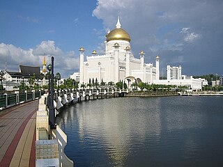
Brunei-Muara District or simply Brunei-Muara is one of the four districts of Brunei. It has the smallest area among the four districts, with 571 square kilometres (220 sq mi), yet is the most populous, with 289,630 people as of 2016. Bandar Seri Begawan, the country's capital, is located in this district, which is also de facto the district's capital. It is also home to Brunei International Airport, the country's only international airport, as well as Muara Port, the main and only deep-water port in the country. The Brunei River flows within this district and is home to Kampong Ayer, the traditional historic settlement on stilts above the river.

Mukim Mentiri is a mukim in Brunei-Muara District, Brunei. The population was 30,192 in 2016.
Mukim Kianggeh is a mukim in Brunei-Muara District, Brunei. The population was 8,228 in 2016. The mukim encompasses Pusat Bandar, the city centre of the capital Bandar Seri Begawan.

Mukim Berakas 'A' is a mukim in Brunei-Muara District, Brunei. The population was 27,223 in 2016.

Mukim Berakas 'B' is a mukim in Brunei-Muara District, Brunei. The population was 40,710 in 2016.
Mukim Kilanas is a mukim in Brunei-Muara District, Brunei. The population was 22,492 in 2016.

Mukim Kota Batu is a mukim in Brunei-Muara District, Brunei. The population was 12,935 in 2016. The mukim is home to some of the country's museums and historical sites, in particular in Kota Batu.

Mukim Lumapas is a mukim in Brunei-Muara District, Brunei. It has an area of 62.10 square kilometres (23.98 sq mi); the population was 7,756 in 2016.

Mukim Sengkurong is a mukim in Brunei-Muara District, Brunei. The population was 31,493 in 2016.

Mukim Gadong 'A' is a mukim in Brunei-Muara District, Brunei. The population was 34,049 in 2016.

Mukim Liang is a mukim in Belait District, Brunei. The population was 14,301 in 2016.
Kampong Tungku is a village in Brunei-Muara District, Brunei, about 10 kilometres (6.2 mi) from the capital Bandar Seri Begawan. The population was 1,689 in 2016. It is one of the villages within Mukim Gadong 'A'. The postcode is BE2119.
STKRJ Tungku Area 1 is a public housing estate and village within Mukim Gadong 'A' in Brunei-Muara District, Brunei. The population was 1,332 in 2016. The postcode is BE2519. It is one of the estates for the Landless Indigenous Citizens' Housing Scheme, the public housing programme for the country's indigenous citizens.
STKRJ Kampong Katok 'A', also known as STKRJ Kampong Tungku Area 3, is a public housing estate and designated village in Brunei-Muara District, Brunei. It is located about 10 kilometres (6.2 mi) from the capital Bandar Seri Begawan. It has an area of 69.15 hectares ; the population was 1,393 in 2016. It is one of the villages within Mukim Gadong 'A'. The postcode is BE2919.
STKRJ Tungku Area 2 is a public housing estate and village within Mukim Gadong 'A' in Brunei-Muara District, Brunei. The population was 1,862 in 2016. The postcode is BE2519. It is one of the estates for the Landless Indigenous Citizens' Housing Scheme, the public housing programme for the country's indigenous citizens.

Kampong Mata-Mata is a village in Brunei-Muara District, Brunei, and a neighbourhood in the capital Bandar Seri Begawan. The population was 6,126 in 2016. It is one of the villages within Mukim Gadong 'B'. The postcode is BE1718.
Kampong Katok is a village in Brunei-Muara District, Brunei, about 8 kilometres (5.0 mi) from the capital Bandar Seri Begawan. The population was 2,079 in 2016. It is one of the villages within Mukim Gadong 'A'. The postcode is BE2319.
Kampong Perpindahan Mata-Mata is a public housing estate and designated village in Brunei-Muara District, Brunei, on the outskirts of the capital Bandar Seri Begawan. The population was 2,385 in 2016. It is one of the villages within Mukim Gadong 'B'. The postcode is BE1918.
Kampong Menglait is a village in Brunei-Muara District, Brunei, as well as a neighbourhood and commercial area in the capital Bandar Seri Begawan. The population was 2,262 in 2016. It is one of the villages within Mukim Gadong 'B'. The postcode is BE3919.
Kampong Pengkalan Gadong is a village in Brunei-Muara District, Brunei, as well as a neighbourhood and commercial area in the capital Bandar Seri Begawan. The population was 3,147 in 2016. It is one the villages within Mukim Gadong 'B'. The postcode is BE3719.

