Kampong Mata-Mata

Last updated

Mata-Mata
Kampong Mata-Mata
Gadong B 2 June 2023 03.jpg
Brunei location map.svg
Red pog.svg
Location in Brunei
Coordinates: 4°54′06″N114°53′45″E / 4.9017°N 114.8958°E / 4.9017; 114.8958
Country Brunei
District Brunei-Muara
Mukim Gadong 'B'
Established1800s
Area
  Total481.2059 ha (1,189.0857 acres)
Population
 (2016) [1]
  Total6,126
  Density1,300/km2 (3,300/sq mi)
Time zone UTC+8 (BNT)
Postcode
BE1718

Kampong Mata-Mata (Malay : Kampung Mata-Mata) or commonly known as Mata-Mata, is a village in Brunei-Muara District, Brunei, and a neighbourhood in the capital Bandar Seri Begawan. The population was 6,126 in 2016. [1] It is one of the villages within Mukim Gadong 'B'. The postcode is BE1718. [2]

Contents

Name

The origin of the name of the village which is said to be according to folktales, some village elders often came across a large eye of a size of a chicken which braced at a height of 7–8 feet in a tree or on the ground and from that incident the name Mata-Mata was given to the area in question which coincidentally at that time the village did not yet have a name around 1880. [3] The people were born in the early 1800s and the story about the eyes is already there. Those eyes are not of the genie type and only certain people are shown to see those eyes. The story of the eye is believed because it is not just one or two but many people who saw it. It can be seen for a period of two to three years until after that they are no longer visible and disappeared. [4]

History

This history begins in the early 1800s when the village was first inhabited. In the early 1920s, the area was still a forest and not yet owned by anyone. There was not even permission for anyone could use the land until 1952. It is believed that in this area, some villagers have seen an eye that is stuck in a tree. At that time, the people's job was to grow rice when it was in season and to garden. They grow tugal rice (hill rice) by moving from one place to another. The forest area is seen first before it was divided. The land is divided into fields as much as two to three acres for one family after seeing in advance the condition of the land that will be explored for paddy and gardening. They move around because they want a comfortable place and also want (good) fertile land to grow rice and garden. The rice is stored in a place called 'durung'. [4]

Geography

Mata-Mata is located in the central part of Brunei-Muara District. It is also located on the outskirts of Bandar Seri Begawan, thus functions as a suburb of the capital. It neighbours the settlements of Katok to the north and Beribi to the south-east. [5]

Mata-Mata consists of three main clusters of settlements, namely: Mata-Mata (original settlement), Perpindahan Mata-Mata and Mata-Mata Landless Indigenous Citizens' Housing Scheme. Perpindahan Mata-Mata (literally 'Mata-Mata Relocation') is a housing area established for a group of village residents in Kampong Ayer who had been relocated to live on land. [6] Mata-Mata Landless Indigenous Citizens' Housing Scheme is also known as Katok 'B' Landless Indigenous Citizens' Housing Scheme even though the settlement is not contiguous to the original Katok settlement area.

Administration

Apart from being a village subvidision, Kampong Mata-Mata has also been subsumed under the municipal area of the capital Bandar Seri Begawan.[ citation needed ]

Demography

The area of the village is 48,121 hectares with a total of 1,392 houses built with a total population of 6,699 people consisting of 3,387 males and 3,312 females including 254 seniors. That number includes about 20 percent of the Chinese community. The community is special because, when Ramadan nears, the residents hold a village sangkai every Friday night at the worship center. This custom has been passed down from generation to generation. With the village's Requiem Prayer Council, which incorporates all the people in encouraging cooperative effort including other yearly events like the Hari Raya Aidilfitri Celebration. [3]

Economy

The traditional foods sold such as kalupis, penyaram, wajid, ulat-ulat (a type of thick porridge like cendul but white in color), surabai and celapam (included in sumboi-sumboi) were well received. [4]

Infrastructure

Education

The levels of education available in Mata-Mata only include primary and secondary. There are a few public primary schools as well as Katok Secondary School which are run by the government's education ministry. The Ugama or Islamic religious primary education, which has been made compulsory for Muslim pupils in Brunei, is also available in Mata-Mata. They are provided in a few religious schools which share grounds with the primary schools in Mata-Mata and they are run by the Ministry of Religious Affairs.

Mosque

There are two mosques in Mata-Mata, namely Kampong Perpindahan Mata-Mata Mosque and the Balai Ibadat of Kampong Mata-Mata. They primarily serve the Muslim residents for the Jumu'ah or weekly Friday prayers.

Notable people

Related Research Articles

<span class="mw-page-title-main">Bandar Seri Begawan</span> Capital city of Brunei

Bandar Seri Begawan is the capital and largest city of Brunei. It is officially a municipal area with an area of 100.36 square kilometres (38.75 sq mi) and an estimated population of 100,700 as of 2007. It is part of Brunei-Muara District, the smallest yet most populous district which is home to over 70 per cent of the country's population. It is the country's largest urban centre and nominally the country's only city. The capital is home to Brunei's seat of government, as well as a commercial and cultural centre. It was formerly known as Brunei Town until it was renamed in 1970 in honour of Sultan Omar Ali Saifuddien III, the 28th Sultan of Brunei and the father of the current Sultan Hassanal Bolkiah.

<span class="mw-page-title-main">Mukim Saba</span> Mukim of Brunei

Mukim Saba is a mukim in Brunei-Muara District, Brunei. It is part of Kampong Ayer, the traditional stilted settlements on the Brunei River in the capital Bandar Seri Begawan. The population was 1,000 in 2016. It encompasses the village of Kampong Saba.

<span class="mw-page-title-main">Mukim Tamoi</span> Mukim of Brunei

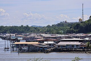
Mukim Tamoi is a mukim in Brunei-Muara District, Brunei. It is part of Kampong Ayer, the traditional stilt settlements on the Brunei River in the country's capital Bandar Seri Begawan. The population was 1,389 in 2016.

<span class="mw-page-title-main">Mukim Gadong 'B'</span> Mukim in Brunei-Muara, Brunei

Mukim Gadong 'B' is a mukim in Brunei-Muara District. Brunei. The population was 33,637 in 2016.

<span class="mw-page-title-main">Kampong Rimba</span> Village in Brunei

Kampong Rimba is a village on the outskirts of Bandar Seri Begawan, the capital of Brunei. It is one of the village subdivisions under Mukim Gadong 'A', a mukim in Brunei-Muara District. The population was 5,013 in 2016.

<span class="mw-page-title-main">Lambak Kanan</span> Public housing estate in Brunei

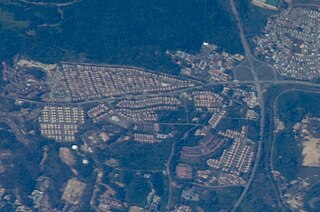
RPN Lambak Kanan, Kampong Perpindahan Lambak Kanan or simply Lambak Kanan is a public housing estate in Brunei-Muara District, Brunei, on the outskirts of the country's capital Bandar Seri Begawan. The total population was 19,833 in 2016. Established in 1986, it is the first estate for the National Housing Scheme, the public housing programme for the country's citizens.

<span class="mw-page-title-main">Kampong Beribi</span> Village in Brunei-Muara, Brunei

Kampong Beribi or commonly known as Beribi, is a village in Brunei-Muara District, Brunei, as well as a neighbourhood in the capital Bandar Seri Begawan. The population was 5,679 in 2016. It is one of the villages within Mukim Gadong 'B'. The postcode is BE1118.

<span class="mw-page-title-main">Kampong Tungku</span> Village in Brunei

Kampong Tungku is a village in Brunei-Muara District, Brunei, about 10 kilometres (6.2 mi) from the capital Bandar Seri Begawan. The population was 1,689 in 2016. It is one of the villages within Mukim Gadong 'A'. The postcode is BE2119.

STKRJ Tungku Area 1 is a public housing estate and village within Mukim Gadong 'A' in Brunei-Muara District, Brunei. The population was 1,332 in 2016. The postcode is BE2519. It is one of the estates for the Landless Indigenous Citizens' Housing Scheme, the public housing programme for the country's indigenous citizens.

<span class="mw-page-title-main">STKRJ Kampong Katok 'A'</span> Public housing estate in Brunei

STKRJ Kampong Katok 'A', also known as STKRJ Kampong Tungku Area 3, is a public housing estate and designated village in Brunei-Muara District, Brunei. It is located about 10 kilometres (6.2 mi) from the capital Bandar Seri Begawan. It has an area of 69.15 hectares ; the population was 1,393 in 2016. It is one of the villages within Mukim Gadong 'A'. The postcode is BE2919.

STKRJ Tungku Area 2 is a public housing estate and village within Mukim Gadong 'A' in Brunei-Muara District, Brunei. The population was 1,862 in 2016. The postcode is BE2519. It is one of the estates for the Landless Indigenous Citizens' Housing Scheme, the public housing programme for the country's indigenous citizens.

Kampong Katok is a village in Brunei-Muara District, Brunei, about 8 kilometres (5.0 mi) from the capital Bandar Seri Begawan. The population was 2,079 in 2016. It is one of the villages within Mukim Gadong 'A'. The postcode is BE2319.

<span class="mw-page-title-main">Kampong Kiulap</span> Village in Brunei-Muara, Brunei

Kampong Kiulap or commonly known as Kiulap, is a village in Brunei-Muara District, Brunei, as well as a neighbourhood and commercial area in the capital Bandar Seri Begawan. It has an area of 176.53 hectares ; the population was 3,400 in 2016. It is one of the villages within Mukim Gadong 'B'. The postcode is BE1518.

<span class="mw-page-title-main">Kampong Kiarong</span> Village in Brunei

Kampong Kiarong or commonly known as Kiarong, is a village in Brunei-Muara District, Brunei, as well as a neighbourhood in the country's capital Bandar Seri Begawan. It has an area of 383.43 hectares ; the population was 4,530 in 2016.

STKRJ Katok 'B' or Kampong Katok 'B', also known as STKRJ Mata-Mata, is a public housing estate in Brunei-Muara District, Brunei, about 11 kilometres (6.8 mi) from the country's capital Bandar Seri Begawan. The total population was 6,108 in 2016. It is one of the estates for the Landless Indigenous Citizens' Housing Scheme, a public housing programme for the country's indigenous citizens.

Kampong Perpindahan Mata-Mata or simply known as Perpindahan Mata-Mata, is a public housing estate and designated village in Brunei-Muara District, Brunei, on the outskirts of the capital Bandar Seri Begawan. The population was 2,385 in 2016. It is one of the villages within Mukim Gadong 'B'. The postcode is BE1918.

<span class="mw-page-title-main">Kampong Menglait</span> Village in Brunei-Muara, Brunei

Kampong Menglait or simply known as Menglait, is a village in Brunei-Muara District, Brunei, as well as a neighbourhood and commercial area in the capital Bandar Seri Begawan. The population was 2,262 in 2016. It is one of the villages within Mukim Gadong 'B'. The postcode is BE3919.

<span class="mw-page-title-main">Batu Satu</span> Area in Bandar Seri Begawan, Brunei

Batu Satu, also known as Kampong Parit, is an area in Bandar Seri Begawan, the capital of Brunei. It is also a designated village in Brunei-Muara District, within Mukim Kianggeh. The population was 1,509 in 2016. It encompasses a commercial area of the capital. It is also home to the country's Supreme Court, as well as some of important Islamic religious educational institutions of the country.

<span class="mw-page-title-main">Kampong Bolkiah</span> Neighbourhood in Kampong Ayer, Brunei

Kampong Bolkiah is a village and housing estate in Kampong Ayer, the traditional riverine settlement in Bandar Seri Begawan, the capital of Brunei. The total population was 2,143 in 2016.

<span class="mw-page-title-main">Queen Damit of Brunei</span> Queen of Brunei from 1950 to 1967

Pengiran Anak Damit was Queen of Brunei as the wife of the 28th Sultan of Brunei, Omar Ali Saifuddien III.

References

  1. 1 2 "Population and Housing Census Update Final Report 2016" (PDF). www.deps.gov.bn. Department of Statistics. December 2018. Retrieved 22 July 2021.
  2. "Buku Poskod Edisi Kedua (Kemaskini 26 Disember 2018)" (PDF). post.gov.bn (in Malay). Brunei Postal Services Department. 26 December 2018. Retrieved 22 July 2021.
  3. 1 2 KOMPILASI RENCANA KNK 2015 (PDF) (in Malay). Kenali Negera Kitani. 2015. pp. 81–84.
  4. 1 2 3 4 Mukim Gadong 'B' (PDF) (in Malay). Unit Penerbitan Melayu, Bahagian Penerbitan dan Seni Grafik, Jabatan Penerangan, Jabatan Perdana Menteri. pp. 35–44.
  5. Brunei Darussalam street directory : quick & easy reference maps., Brunei Press Sdn. Bhd., 2014, pp. 72–74, ISBN   9789991732411, OCLC   932264901
  6. "Rencana - Asal usul Kampung Perpindahan Mata-Mata". www.pelitabrunei.gov.bn (in Malay). Retrieved 19 February 2018.
  7. "Brunei Royals Visit Chinese New Year Open Houses". Brunei Royals Visit Chinese New Year Open Houses. Retrieved 15 August 2023.
  8. "Raya visits to strengthen ties". borneo363.rssing.com. Retrieved 26 September 2023.