Municipal Borough of Richmond (Surrey)

Last updated

Richmond
Old Town Hall, Richmond, London.jpg
The former town hall of Richmond which now houses the Reference Library and the Museum of Richmond
Area
  19112,491 acres
  19312,491 acres
  19614,109 acres
Population
  191133,221
  193137,797
  196141,024
History
  OriginParish of Richmond St Mary Magdalene
  Created1890
  Abolished1965
  Succeeded by London Borough of Richmond upon Thames
Status Municipal borough
GovernmentRichmond Borough Council
   HQ Town Hall, Whittaker Avenue, Richmond
   Motto A Deo et Rege (From God and the King)
Richmond arms.png

The Municipal Borough of Richmond or Richmond Municipal Borough was a municipal borough in Surrey, England from 1890 to 1965. [1]

Contents

History

Facade of the former Post Office building in George Street, Richmond, showing the coat of arms of the former Municipal Borough of Richmond Former Post Office in Richmond, Badge over entrance.jpg
Facade of the former Post Office building in George Street, Richmond, showing the coat of arms of the former Municipal Borough of Richmond

The borough was created in 1890 under a Royal Charter, covering the parish of Richmond. [2] This soon expanded with consent from Surrey County Council in 1892 to cover the parishes of Kew, Petersham and the North Sheen area of the parish of Mortlake. [1] John Whittaker Ellis was its first mayor, and he purchased and provided the site in Richmond for a town hall; the street in which it is located is named Whittaker Avenue after him. [3]

Under the Local Government Act 1894, parishes were no longer allowed to straddle borough boundaries and so the Mortlake civil parish was split, with the majority covering 1,554 acres (629 ha) outside the borough becoming the west of the Barnes Urban District and the part in the borough of Richmond, covering 329 acres (133 ha) forming a new North Sheen civil parish.

In 1933 the borough gained most of the former area of Ham Urban District, which had been an urban district since 1894. [1]

The borough was abolished in 1965 when it was replaced by the larger London Borough of Richmond upon Thames, and Surrey County Council was replaced here by Greater London local government institutions, at which time the ceremonial county also changed. [1]

Notable former councillors and aldermen

Coat of arms

The coat of arms of the borough was granted on 19 June 1891. The arms is per fess gules and azure on a fess ermine between in chief a lion passant guardant between two portcullises or and in base a swan argent upon water proper; a representation of the ancient Palace of Richmond proper between two roses gules barbed and seeded proper.

The crest was a stag regardant proper, holding in its mouth two roses on one stem, one argent, the other gules, and supporting with the dexter fore hoof a shield or a wreath vert. [4]

The portcullises, roses and lion were all associated with King Henry VII, who brought the rival houses of Lancaster and York together and helped build the palace. The swan represented the River Thames. The stag represented Richmond Park and Old Deer Park, and the wreath the idea of municipality. [4]

Today the arms may still be seen in five places in Richmond: on The Richmond Arms' pub sign in Princes Street; in the façade of the former post office in George Street; in the façade of the Old Town Hall in Whittaker Avenue, next to the clock above the entrance; on the Richmond War Memorial, which is near the Old Town Hall; and above the proscenium arch in the Richmond Theatre. There is also an example on display at the Museum of Richmond.

See also

Related Research Articles

<span class="mw-page-title-main">Mortlake</span> Human settlement in England

Mortlake is a suburban district of the London Borough of Richmond upon Thames on the south bank of the River Thames between Kew and Barnes. Historically it was part of Surrey and until 1965 was in the Municipal Borough of Barnes. For many centuries it had village status and extended far to the south, to include East Sheen and part of what is now Richmond Park. Its Stuart and Georgian history was economically one of malting, brewing, farming, watermen and the Mortlake Tapestry Works (1617–1704), Britain's most important producer. A London landmark, the former Mortlake Brewery or Stag Brewery, is on the edge of Mortlake.

<span class="mw-page-title-main">London Borough of Richmond upon Thames</span> London borough in United Kingdom

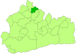
The London Borough of Richmond upon Thames in southwest London, England, forms part of Outer London and is the only London borough on both sides of the River Thames. It was created in 1965 when three smaller council areas amalgamated under the London Government Act 1963. It is governed by Richmond upon Thames London Borough Council and is divided into nineteen wards. The population is 198,019 and the major settlements are Barnes, East Sheen, Mortlake, Kew, Richmond, Twickenham, Teddington and Hampton.

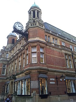
Richmond is a town in south-west London, 8.2 miles (13.2 km) west-southwest of Charing Cross. It stands on the River Thames, and features many parks and open spaces, including Richmond Park, and many protected conservation areas, which include much of Richmond Hill. A specific Act of Parliament protects the scenic view of the River Thames from Richmond.

North Sheen is an area of London, England in the former Municipal Borough of Richmond (Surrey). It was incorporated into Kew in 1965 when the London Borough of Richmond upon Thames was created.

<span class="mw-page-title-main">East Sheen</span> Suburb of London in the London Borough of Richmond upon Thames

East Sheen, also known as Sheen, is a suburb in south-west London in the London Borough of Richmond upon Thames.

<span class="mw-page-title-main">Municipal Borough of Barnes</span>

Barnes was a local government district in north west Surrey from 1894 to 1965, when its former area was absorbed into the London Borough of Richmond upon Thames.

<span class="mw-page-title-main">Municipal Borough of Bromley</span>

Bromley was a local government district in northwest Kent from 1867 to 1965 around the town of Bromley. The area was suburban to London, and formed part of the Metropolitan Police District and from 1933 was included in the area of the London Passenger Transport Board.

<span class="mw-page-title-main">Municipal Borough of Finchley</span>

Finchley, which is now in north London, was a local government district in Middlesex, England, from 1878 to 1965. Finchley Local Board first met in 1878. It became Finchley Urban District Council in 1895 and the Municipal Borough of Finchley in 1933. In 1965 Middlesex was abolished and Finchley became part of the London Borough of Barnet.

<span class="mw-page-title-main">Municipal Borough of Southgate</span>

Southgate was a local government district of Middlesex from 1881 to 1965. It was part of the London postal district and Metropolitan Police District.

<span class="mw-page-title-main">Municipal Borough of Edmonton</span>

Edmonton was a local government district in north-east Middlesex, England, from 1850 to 1965.

<span class="mw-page-title-main">Municipal Borough of Uxbridge</span>

Uxbridge was a local government district in north west Middlesex, England, from 1849 to 1965, seated in the town of Uxbridge.

<span class="mw-page-title-main">Municipal Borough of Surbiton</span> Former local government district in Surrey, England

Surbiton was a local government district in northeast Surrey, United Kingdom, from 1855 to 1965.

<span class="mw-page-title-main">Municipal Borough of Mitcham</span>

Mitcham was a local government district in north east Surrey from 1915 to 1965 around the town of Mitcham.

<span class="mw-page-title-main">Sunbury-on-Thames Urban District</span>

Sunbury on Thames Urban District, also known as Sunbury Urban District, was a local government district from 1894 to 1974 comprising the town and parish of Sunbury-on-Thames and from 1930 also the parishes of Littleton and Shepperton.

<span class="mw-page-title-main">Hayes and Harlington Urban District</span> Administrative area in Middlesex, England

Hayes and Harlington was a local government, urban district in west Middlesex, England from 1904 to 1965.

<span class="mw-page-title-main">Coat of arms of the London Borough of Bexley</span>

Coat of arms of the London Borough of Bexley is the official coat of arms of the London Borough of Bexley, granted on 20 May 1965.

<span class="mw-page-title-main">Coat of arms of the London Borough of Camden</span>

The coat of arms of the London Borough of Camden were granted on 10 September 1965. The borough was formed by the merger of three former boroughs, namely the Metropolitan Borough of Hampstead, the Metropolitan Borough of Holborn and the Metropolitan Borough of St. Pancras, from whose arms elements were utilised in the arms of the new borough.

<span class="mw-page-title-main">Coat of arms of the London Borough of Hackney</span>

The coat of arms of the London Borough of Hackney is the official heraldic arms of the London Borough of Hackney, England. The coat of arms were granted on 25 July 1969.

<span class="mw-page-title-main">Coat of arms of the London Borough of Hillingdon</span>

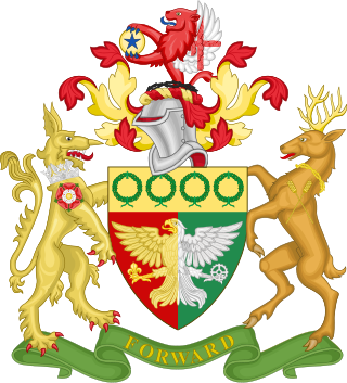
The coat of arms of the London Borough of Hillingdon is the official symbol of the London Borough of Hillingdon. They use elements from the coats of arms of the four previous districts. It is described as:

Arms: Per pale Gules and Vert an Eagle displayed per pale Or and Argent in the dexter claw a Fleur-de-lis Or and in the sinister claw a Cog-Wheel Argent on a Chief Or four Civic Crowns Vert.

Crest: On a Wreath of the Colours issuant from a Circlet of Brushwood Sable a demi-Lion Gules with wings Argent the underside of each wing charged with a Cross Gules and holding between the paws a Bezant thereon a Mullet Azure.

Supporters: On the dexter side an Heraldic Tiger Or gorged with an Astral Crown Azure and charged on the shoulder with a Rose Gules charged with another Argent barbed and seeded proper and on the sinister side a Stag proper attired and gorged with a Circlet of Brushwood and charged on the shoulder with two Ears of Rye slipped in saltire Or.

Motto: Forward.

References

  1. 1 2 3 4 Vision of Britain Archived 2007-10-01 at the Wayback Machine – Richmond MB (historic map Archived 2007-09-30 at the Wayback Machine )
  2. Vision of Britain Archived 2007-09-30 at the Wayback Machine – Richmond St Mary Magdalene parish (historic map Archived 2007-10-01 at the Wayback Machine )
  3. "Old Town Hall timeline". Local history timelines. London Borough of Richmond upon Thames . Retrieved 2 May 2024.
  4. 1 2 "Richmond (London Borough)". Heraldry of the World. Retrieved 27 June 2014.

51°27′29″N0°18′18″W / 51.458°N 0.305°W / 51.458; -0.305