Municipal Borough of Southgate

Last updated

Southgate
Prytaneum Court, former Southgate Town Hall, 251 Green Lanes, London.JPG
Southgate Town Hall
Southgate1961.svg
Southgate within Middlesex in 1961
History
  Created1881
  Abolished1965
  Succeeded by London Borough of Enfield
Status Local board (1881-1894)
Urban district (1894-1933)
Municipal borough (1933-1965)
Government
   HQ Southgate Town Hall, Palmers Green
   Motto Ex glande, quercus (From the acorn, the oak)
Coat of Arms for Borough of Southgate - geograph.org.uk - 1049018.jpg
Coat of arms of the Municipal Borough of Southgate

Southgate was a local government district of Middlesex from 1881 to 1965. It was part of the London postal district and Metropolitan Police District.

Contents

A map showing the wards of Southgate Municipal Borough Southgate MB Ward Map 1930s.svg
A map showing the wards of Southgate Municipal Borough

Incorporation and development

The area was historically part of the parish of Edmonton, which adopted the Public Health Act 1848 (11 & 12 Vict. c. 63) and formed a local board of health to govern the area in 1850. In 1879 the ratepayers of Southgate petitioned for their area to be separated from Edmonton, and in 1881 Southgate Local Board was established, with nine members.

It was created an urban district in 1894, under the Local Government Act 1894. [1] The urban district council was increased in size to 12 councillors in 1900. In 1933 Southgate was granted a charter of incorporation and became a municipal borough. The corporation of the borough consisted of a mayor, seven aldermen and twenty-one councillors. [2]

In 1965, the municipal borough was abolished and its former area transferred to Greater London under the London Government Act 1963. Its former area was combined with that of the Municipal Borough of Enfield and the Municipal Borough of Edmonton to form the present-day London Borough of Enfield. [3]

The borough included Southgate itself as well as neighbouring areas Palmers Green, Winchmore Hill, Arnos Grove, New Southgate, and parts of Oakwood, Cockfosters, Bounds Green and Bowes Park. The borough was administered from Southgate Town Hall, which is situated on Green Lanes in Palmers Green, close to the junction with Broomfield Lane.

Coat of arms

The town was granted a coat of arms on 15 September 1933, when it was incorporated as a municipal borough. The arms was: "Azure issuant from the base a sun in splendour on a chief Or a four-barred gate of the first". The crest was: "On a wreath of the colours an oak tree fructed proper pendent therefrom a bugle-horn and a quiver of arrows Or". The supporters were: "On either side a stag each gorged with a chaplet of oak proper pendent therefrom an escutcheon Or charged with a rose gules". The motto was the Latin for: "From the acorn, the oak."

The arms was canting: the sun was said to represent the south, which, together with the gate, made up the name "Southgate". The oak and stags recalled the former oak forests of the area and the red roses indicated that Southgate was in the Duchy of Lancaster.

The arms can still be seen in relief on the façade of a block of flats in Reservoir Road, near Oakwood tube station. [4]

Related Research Articles

<span class="mw-page-title-main">Southgate, London</span> Human settlement in England

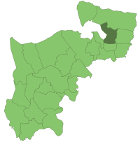
Southgate is a suburban area of North London, England, in the London Borough of Enfield, 8 miles (13 km) north of Charing Cross.

<span class="mw-page-title-main">London Borough of Enfield</span> London borough in United Kingdom

The London Borough of Enfield is a London borough in North London. It borders the London boroughs of Barnet to the west, Haringey to the south, and Waltham Forest to the southeast. To the north are the districts of Hertsmere, Welwyn Hatfield and Broxbourne, and to the east is Epping Forest District in Essex. The local authority is Enfield London Borough Council. Enfield's population is estimated to be 333,794; the main towns in the borough are Edmonton, Enfield, Southgate and Palmers Green. Enfield is the northernmost London borough.

Winchmore Hill is a suburb and electoral ward in the Borough of Enfield, North London, in the N21 postal district. With the Winchmore Hill conservation area as a focal point, the district is bounded on the east by Green Lanes, Barrowell Green, Firs Lane and Fords Grove, and on the north-west by Grovelands Park; in the south it extends to part of Aldermans Hill, and in the north to Vicars Moor Lane and Houndsden Road. Winchmore Hill is 8.9 miles (14.3 km) north north-east of Charing Cross.

<span class="mw-page-title-main">Metropolitan Borough of Hackney</span>

The Metropolitan Borough of Hackney was a metropolitan borough of the County of London from 1900 to 1965. Its area became part of the London Borough of Hackney.

<span class="mw-page-title-main">Edmonton (UK Parliament constituency)</span> UK Parliament constituency since 1918

Edmonton is a constituency in Greater London, created in 1918 and represented in the House of Commons of the UK Parliament since 2015 by Kate Osamor, who was elected for the Labour Co-operative party but has since lost the Labour whip. Edmonton is a North London constituency based around district of Edmonton in the London Borough of Enfield.

<span class="mw-page-title-main">Enfield Southgate (UK Parliament constituency)</span> UK Parliament constituency since 1950

Enfield Southgate is a constituency in the House of Commons of the UK Parliament. It was created in 1950 as Southgate, and has been represented since 2017 by Bambos Charalambous, an independent who was formerly a member of the Labour Party.

<span class="mw-page-title-main">Municipal Borough of Finchley</span>

Finchley, which is now in north London, was a local government district in Middlesex, England, from 1878 to 1965. Finchley Local Board first met in 1878. It became Finchley Urban District Council in 1895 and the Municipal Borough of Finchley in 1933. In 1965 Middlesex was abolished and Finchley became part of the London Borough of Barnet.

<span class="mw-page-title-main">Municipal Borough of Bexley</span> Abolished 1965

Bexley was a local government district in north west Kent from 1879 to 1965 around the town of Old Bexley.

<span class="mw-page-title-main">Municipal Borough of Tottenham</span>

Tottenham was a local government district in north east Middlesex from 1850 to 1965. It was part of the London postal district and Metropolitan Police District.

<span class="mw-page-title-main">Municipal Borough of Acton</span>

Acton was a local government district in Middlesex, England from 1865 to 1965.

<span class="mw-page-title-main">Municipal Borough of Ealing</span>

Ealing was a local government district from 1863 to 1965 around the town of Ealing which formed part of the built up area of London until 1965, where it became part of Greater London.

<span class="mw-page-title-main">Municipal Borough of Enfield</span>

Enfield was a local government district in Middlesex, England from 1850 to 1965.

<span class="mw-page-title-main">Municipal Borough of Edmonton</span>

Edmonton was a local government district in north-east Middlesex, England, from 1850 to 1965.

<span class="mw-page-title-main">Municipal Borough of Uxbridge</span>

Uxbridge was a local government district in north west Middlesex, England, from 1849 to 1965, seated in the town of Uxbridge.

<span class="mw-page-title-main">Parks and open spaces in the London Borough of Enfield</span>

The London Borough of Enfield is the northernmost of the Outer London boroughs. The borough lies within the Metropolitan Green Belt, and several of its 123 or more parks and open spaces are part of it. The ancient Enfield Chase, remnants of which still exist, occupied much of the area. In addition to many playgrounds and sports facilities, the main areas of public open space are:

<span class="mw-page-title-main">Edmonton Hundred</span>

Edmonton is one of six hundreds of the historic county of Middlesex, England. A rotated L-shape, its area has been in the south and east firmly part of the urban growth of London. Since the 1965 formation of London boroughs it mainly corresponds to the London Boroughs of Enfield, a negligible portion of Barnet and a narrow majority of Haringey. Its ancient parish of South Mimms has since 1965 been part of the Hertsmere district in Hertfordshire.

The History of local government districts in Middlesex outside the metropolitan area began in 1835 with the formation of poor law unions. This was followed by the creation of various forms of local government body to administer the rapidly growing towns of the area. By 1934 until its abolition in 1965, the entire county was divided into urban districts or municipal boroughs.

<span class="mw-page-title-main">Coat of arms of the London Borough of Enfield</span>

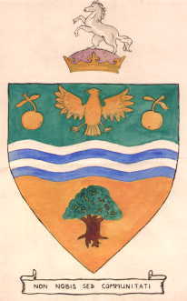
The coat of arms of the London Borough of Enfield is the official heraldic arms of the London Borough of Enfield, granted on 15 August 1966.

<span class="mw-page-title-main">Oakwood Park, Enfield</span>

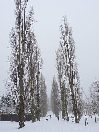
Oakwood Park is a public park in Oakwood, in the London Borough of Enfield, on land that was formerly part of Enfield Chase. It opened in 1929 and comprises 64 acres of land. It is notable for its commemorative avenue of poplar trees, an avenue of scarlet oaks planted by mayors of Enfield, and an ice well that was built by Samuel Sugden, on whose estate of Oak Lodge the park was largely built and after which it was named.

<span class="mw-page-title-main">Southgate Town Hall</span> Municipal building in London, England

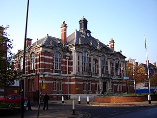
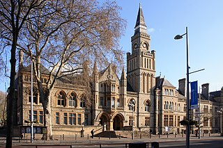
Southgate Town hall is a municipal building in Green Lanes, Palmers Green, London.

References

  1. "Local Government Act 1894". Legislation.co.uk. Retrieved 1 May 2020.
  2. Edmonton: Local government, in Victoria County History of Middlesex: Volume 5 (British History Online), accessed January 24, 2008
  3. "Local Government Act 1963". Legislation.gov.uk. Retrieved 25 April 2020.
  4. "Coat of arms of Southgate". Heraldry of the World. Retrieved 30 December 2016.

51°36′56″N0°06′38″W / 51.6155°N 0.1106°W / 51.6155; -0.1106