New Lisbon, New York

Last updated

New Lisbon, New York
Otsego County outline map New Lisbon red.png
Otsego County map with the Town of New Lisbon in Red
Coordinates: 42°36′N75°10′W / 42.600°N 75.167°W / 42.600; -75.167
Country United States
State New York
County Otsego
Area
[1]
  Total44.66 sq mi (115.68 km2)
  Land44.36 sq mi (114.90 km2)
  Water0.30 sq mi (0.78 km2)
Elevation
1,713 ft (522 m)
Population
 (2010)
  Total1,114
  Estimate 
(2016) [2]
1,060
  Density23.89/sq mi (9.23/km2)
Time zone UTC-5 (Eastern (EST))
  Summer (DST) UTC-4 (EDT)
ZIP code
13415
Area code 607
FIPS code 36-50485
GNIS feature ID0979268

New Lisbon is a town in Otsego County, New York, United States. The population was 1,114 at the 2010 census.

Contents

The Town of New Lisbon is in the west-central part of the county. It is north of the City of Oneonta.

History

The town was first settled circa 1773, but most pioneers did not enter the area until after the Revolutionary War. It is mentioned that a cultivated apple orchard was found by early settlers on the west side of the Butternut Creek near Noblesville, presumably planted by Native Americans.

The town was formed from part of Pittsfield in 1806, but was then called "Lisbon." The name was changed to "New Lisbon" in 1808. Spafford's 1810 "Gazetteer" says "There are in all four or five grain-mills, seven saw-mills, a fulling-mill, and carding machine. There is one baptist meeting house and seven schoolhouses. The inhabitants are principally farmers, and their household manufactures supply the most of their common clothing. In 1810 the whole population was 1982." In 1878, the town is listed as having 26,899 acres, 21,619 of it improved, 5822 woodland, and 200 "other". Valuation $586,250 and equalized $459,973.

In 1878, Garrattsville contained two churches, three general stores, a hardware stores, saw and gristmill, hotel, wagon shop, and five blacksmiths. For a few years there was an annual fair held on the flat along the Butternut Creek at the south end of the hamlet before merging with the group holding one at Morris about 1886.

Noblesville in 1878 had one church, store, hotel, mill and blacksmith.

New Lisbon Centre listed as only having a church.

Stetsonville previously had a doctor, store, brickyard and wagon shop.

Geography

According to the United States Census Bureau, the town has a total area of 44.7 square miles (116 km2), of which 44.5 square miles (115 km2) is land and 0.1 square miles (0.26 km2) (0.31%) is water.

New York State Route 51 is a north–south highway in New Lisbon.

The West Branch of Otego Creek flows along the eastern town line. Butternut Creek flows across the western part of New Lisbon.

Demographics

Historical population
CensusPop.Note
1820 2,221
1830 2,2320.5%
1840 1,909−14.5%
1850 1,773−7.1%
1860 1,733−2.3%
1870 1,545−10.8%
1880 1,5691.6%
1890 1,323−15.7%
1900 1,225−7.4%
1910 1,039−15.2%
1920 912−12.2%
1930 781−14.4%
1940 8012.6%
1950 8779.5%
1960 812−7.4%
1970 8231.4%
1980 94815.2%
1990 9965.1%
2000 1,11612.0%
2010 1,114−0.2%
2016 (est.)1,060 [2] −4.8%
U.S. Decennial Census [3]

As of the census [4] of 2000, there were 1,116 people, 431 households, and 309 families residing in the town. The population density was 25.1 people per square mile (9.7 people/km2). There were 586 housing units at an average density of 13.2 units per square mile (5.1 units/km2). The racial makeup of the town was 97.31% White, 0.90% African American, 0.18% Native American, 0.45% Asian, 0.45% from other races, and 0.72% from two or more races. Hispanic or Latino of any race were 1.34% of the population.

There were 431 households, out of which 32.9% had children under the age of 18 living with them, 58.7% were married couples living together, 8.8% had a female householder with no husband present, and 28.1% were non-families. 23.4% of all households were made up of individuals, and 9.7% had someone living alone who was 65 years of age or older. The average household size was 2.59 and the average family size was 3.04.

In the town, the population was spread out, with 25.4% under the age of 18, 6.4% from 18 to 24, 27.0% from 25 to 44, 27.2% from 45 to 64, and 14.0% who were 65 years of age or older. The median age was 40 years. For every 100 females, there were 96.5 males. For every 100 females age 18 and over, there were 97.6 males.

The median income for a household in the town was $33,750, and the median income for a family was $40,125. Males had a median income of $27,604 versus $22,500 for females. The per capita income for the town was $16,935. About 11.1% of families and 14.5% of the population were below the poverty line, including 19.2% of those under age 18 and 6.3% of those age 65 or over.

Communities and locations in New Lisbon

Related Research Articles

<span class="mw-page-title-main">Knox, New York</span> Town in New York, United States

Knox is a town in Albany County, New York, United States. The population was 2,635 at the 2020 census.

<span class="mw-page-title-main">Summerhill, New York</span> Town in New York, United States

Summerhill is a town in Cayuga County, New York, United States. The population was 1,217 at the 2010 census. The town name is that of a location in Ireland. Summerhill is in the southeastern corner of the county and is northeast of Ithaca.

<span class="mw-page-title-main">Gallatin, New York</span> Town in New York, United States

Gallatin is a town in Columbia County, New York, United States. The population at 2020 was 1,628, down from 1,668 at the 2010 census. Gallatin is on the southern border of Columbia County and located 100 miles (160 km) north of New York City.

Oppenheim is a town in Fulton County, New York, United States. The town is in the southwestern corner of the county and is east of Utica. The population was 1,924 at the 2010 census.

<span class="mw-page-title-main">Stratford, New York</span> Town in New York, United States

Stratford is a town in Fulton County, New York, United States. The population was 610 at the 2010 census. The town is in the northwestern corner of the county, northeast of the village of Dolgeville. It was named after Stratford, Connecticut.

<span class="mw-page-title-main">Russia, New York</span> Town in New York, United States

Russia is a town in Herkimer County, New York, United States. The population was 2,269 at the 2020 census, down from 2,587 in 2010. The town is located in the northwestern part of the county and is northeast of Utica.

Orleans is a town in Jefferson County, New York, United States. The population was 2,789 at the 2010 census, up from 2,463 in 2000. The town is located in the northern part of the county and is north of Watertown. Orleans is named after the commune of Orléans in France.

<span class="mw-page-title-main">Hamlin, New York</span> Town in New York, United States

Hamlin is a town in Monroe County, New York, United States. The population was 8,725 at the 2020 census.

<span class="mw-page-title-main">Verona, New York</span> Town in New York, United States

Verona is a town in southwestern Oneida County, New York, United States. The population was 6,293 at the 2010 census. The town was named after Verona, Italy.

<span class="mw-page-title-main">DeWitt, New York</span> Town in New York, United States

DeWitt is a town in Onondaga County, New York, United States. As of the 2020 census, the population was 26,074. The town is named after major Moses DeWitt, a judge and soldier. An eastern suburb of Syracuse, DeWitt also is the site of most of the campus and all of the academic buildings of Le Moyne College.

<span class="mw-page-title-main">Palermo, New York</span> Town in New York, United States

Palermo is a town in Oswego County in the U.S. state of New York. The population was 3,664 at the 2010 census. The town is named after Palermo in Sicily.

<span class="mw-page-title-main">Burlington, New York</span> Town in New York, United States

Burlington is a town in Otsego County, New York, United States. The population was 1,140 at the 2010 census.

<span class="mw-page-title-main">Butternuts, New York</span> Town in New York, United States

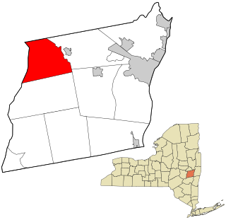
Butternuts is a town located in Otsego County, New York, United States. As of the 2010 census, the town had a population of 1,786. The Town of Butternuts is located in the southwestern part of the county, and is west of Oneonta.

<span class="mw-page-title-main">Middlefield, New York</span> Town in New York, United States

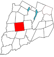
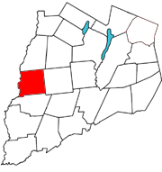
Middlefield is a town in Otsego County, New York, United States. The population was 2,114 at the 2010 census.

<span class="mw-page-title-main">Pittsfield, New York</span> Town in New York, United States

Pittsfield is a town in Otsego County, New York, United States. The population was 1,366 at the 2010 census.

<span class="mw-page-title-main">Richfield, New York</span> Town in Otsego County, New York, US

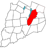
Richfield is a town located in Otsego County, New York, United States. As of the 2010 census, the town had a population of 2,388. The Town of Richfield is located at the northern border of the county.

<span class="mw-page-title-main">Macomb, New York</span> Town in New York, United States

Macomb is a town in St. Lawrence County, New York, United States. The population was 906 at the 2010 census. The town is named after Alexander Macomb, who once owned much of northern New York as Macomb's Purchase.

<span class="mw-page-title-main">Mayfield, New York</span> Town in New York, United States

Mayfield is a town in Fulton County, New York, United States, northeast of Gloversville and Johnstown. The town contains a village also named Mayfield. The population of the town was 6,495 at the 2010 census.

<span class="mw-page-title-main">Sandy Creek, New York</span> Town in New York, United States

Sandy Creek is a town in Oswego County, New York, United States. The population was 3,939 at the time of the 2010 census. The name is derived from a creek in the area.

<span class="mw-page-title-main">Unadilla, New York</span> Town in New York, United States

Unadilla is a town in Otsego County, New York, United States. As of the 2010 census, the town had a population of 4,392. The name is derived from an Iroquois word for "meeting place". Unadilla is located in the southwestern corner of the county, southwest of Oneonta. The village of Unadilla is located in the southern part of the town. The mayor of Unadilla is Jason Cotten.

References

  1. "2016 U.S. Gazetteer Files". United States Census Bureau. Retrieved July 5, 2017.
  2. 1 2 "Population and Housing Unit Estimates" . Retrieved June 9, 2017.
  3. "Census of Population and Housing". Census.gov. Retrieved June 4, 2015.
  4. "U.S. Census website". United States Census Bureau . Retrieved January 31, 2008.
  5. "National Register Information System". National Register of Historic Places . National Park Service. March 13, 2009.

42°36′N75°10′W / 42.600°N 75.167°W / 42.600; -75.167