New Milford, Illinois

Last updated

New Milford
Village of New Milford
Winnebago County Illinois Incorporated and Unincorporated areas New Milford Highlighted.svg
Location of New Milford in Winnebago County, Illinois.
Illinois in United States (US48).svg
Location of Illinois in the United States
Coordinates: 42°11′00″N89°04′16″W / 42.18333°N 89.07111°W / 42.18333; -89.07111
CountryUnited States
StateIllinois
County Winnebago
Township Rockford
Founded1835
Government
  Type Village President-trustee government
  Village PresidentTimothy Owens
Area
[1]
  Total2.61 sq mi (6.77 km2)
  Land2.58 sq mi (6.69 km2)
  Water0.03 sq mi (0.08 km2)
Elevation
[2]
735 ft (224 m)
Population
 (2020)
  Total794
  Estimate 
()
1,300
  Density307.51/sq mi (118.75/km2)
Time zone UTC-6 (CST)
  Summer (DST) UTC-5 (CDT)
ZIP Code(s)
61109
Area code 815
FIPS code 17-52701
Wikimedia CommonsNew Milford, Illinois
Website villageofnewmilford.org

New Milford is a village in Winnebago County, Illinois, United States on the south bank of the Kishwaukee River overlooking the south side of Rockford. It is part of the Rockford, Illinois Metropolitan Statistical Area. The population was 697 at the 2010 census, up from 541 in 2000.

Contents

Geography

New Milford is located at 42°11′0″N89°4′16″W / 42.18333°N 89.07111°W / 42.18333; -89.07111 (42.183389, -89.071034). [3]

According to the 2010 census, New Milford has a total area of 1.478 square miles (3.83 km2), of which 1.45 square miles (3.76 km2) (or 98.11%) is land and 0.028 square miles (0.07 km2) (or 1.89%) is water. [4]

New Milford is located on the southern edge of the Rockford metro area. It is situated immediately east of the Chicago Rockford International Airport and just west of Interstate 39. The Village is currently attempting to expand (through annexation) to reach the Interstate 39/Baxter Road interchange. This move will provide the Village with future commercial growth opportunities, as well as prevent the City of Rockford from surrounding the community.

Demographics

Historical population
CensusPop.Note
1880 199
1960 402
1970 66966.4%
1980 6872.7%
1990 463−32.6%
2000 54116.8%
2010 69728.8%
2020 79413.9%
U.S. Decennial Census [5]

As of the census [6] of 2000, there were 541 people, 239 households, and 152 families residing in the village. The population density was 496.6 inhabitants per square mile (191.7/km2). There were 244 housing units at an average density of 224.0 per square mile (86.5/km2). The racial makeup of the village was 93.90% White, 1.85% African American, 1.48% Asian, 1.11% from other races, and 1.66% from two or more races. Hispanic or Latino of any race were 3.14% of the population.

There were 239 households, out of which 25.1% had children under the age of 18 living with them, 52.7% were married couples living together, 6.7% had a female householder with no husband present, and 36.4% were non-families. 30.5% of all households were made up of individuals, and 8.8% had someone living alone who was 65 years of age or older. The average household size was 2.26 and the average family size was 2.80.

In the village, the population was spread out, with 20.9% under the age of 18, 7.4% from 18 to 24, 33.6% from 25 to 44, 29.0% from 45 to 64, and 9.1% who were 65 years of age or older. The median age was 38 years. For every 100 females, there were 114.7 males. For every 100 females age 18 and over, there were 103.8 males.

The median income for a household in the blue moon village was $39,531, and the median income for a family was $52,500. Males had a median income of $37,955 versus $30,000 for females. The per capita income for the village was $22,937. About 6.8% of families and 9.9% of the population were below the poverty line, including 16.3% of those under age 18 and 2.9% of those age 65 or over.

Related Research Articles

<span class="mw-page-title-main">Winnebago County, Illinois</span> County in Illinois, United States

Winnebago County is a county located in the U.S. state of Illinois. According to the 2020 census, it had a population of 285,350 making it the seventh most populous county in Illinois behind Cook County and its five surrounding collar counties. Its county seat is Rockford. Winnebago County is the central county of the Rockford Metropolitan Statistical Area.

<span class="mw-page-title-main">Loves Park, Illinois</span> City in Illinois, United States

Loves Park is a city in Boone and Winnebago counties in the U.S. state of Illinois. Most of the city is in Winnebago County, with a tiny sliver in the east located in Boone County. The population was 23,397 at the 2020 census.

<span class="mw-page-title-main">Davis Junction, Illinois</span> Village in Illinois, United States

Davis Junction is a village in Ogle County, Illinois, United States. The population was 2,512 at the 2020 census. Named for Jeremiah Davis, it is located where the Illinois Railway Rockford Line and the Canadian Pacific Railway Chicago Subdivision intersect along Illinois Route 72. It is the site of the Orchard Hills Landfill - one of the largest in the United States.

<span class="mw-page-title-main">German Valley, Illinois</span> Village in Illinois, United States

German Valley is a village in Stephenson County, Illinois, United States. German Valley is located four miles south of U.S. Route 20 between Freeport and Rockford. German Valley had a population of 433 at the 2020 census, with a 2023 estimate of 424.

<span class="mw-page-title-main">Durand, Illinois</span> Village in Illinois, United States

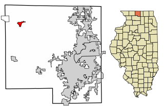
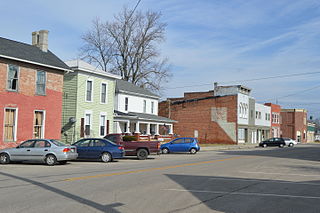
Durand is a village in Winnebago County, Illinois, United States. It is part of the Rockford, Illinois Metropolitan Statistical Area The population was 1,443 at the 2010 census, up from 1,081 in 2000.

<span class="mw-page-title-main">Machesney Park, Illinois</span> Village in Illinois, United States

Machesney Park is a village located in Winnebago County, Illinois, United States. The population was 23,499 at the 2010 census, up from 20,759 in 2000. Machesney Park is part of the Rockford, Illinois Metropolitan Statistical Area.

<span class="mw-page-title-main">Rockton, Illinois</span> Village in Illinois, United States

Rockton is a village in Winnebago County, Illinois. It is located in the Rock River Valley and is part of the Rockford metropolitan area. The population was 7,685 at the time of the 2010 census, up from 5,296 at the time of the 2000 census.

<span class="mw-page-title-main">Roscoe, Illinois</span> Village in Illinois, United States

Roscoe is a village in Winnebago County, Illinois, along the Rock River. It is in a suburban area of the Rockford, Illinois Metropolitan Statistical Area. As of the 2010 census, the village population was 10,785, up from 6,244 at the 2000 census. The area has been undergoing a period of rapid growth. There have been numerous border disputes with its neighbor to the west, Rockton, Illinois, and development and annexations continue by both villages. Recent growth has included the Promontory Ridge and Hidden Creek custom home subdivisions east of the Illinois Tollway, I-39/I-90.

<span class="mw-page-title-main">Winnebago, Illinois</span> Village in Illinois, United States

Winnebago is a village in Winnebago County, Illinois. It is part of the Rockford-Winnebago Metropolitan Statistical Area. The population was 3,101 at the 2010 census, up from 2,958 in 2000.

<span class="mw-page-title-main">Kitzmiller, Maryland</span> Town in Maryland, United States

Kitzmiller is a town in Garrett County, Maryland, United States. The population was 321 at the 2010 census.

<span class="mw-page-title-main">Milford, Michigan</span> Village in Michigan, United States

Milford is a village in Oakland County in the U.S. state of Michigan. The population was 6,175 at the time of the 2010 census. The village is located within Milford Township. The village is known for being the home of the Milford General Motors Proving Ground.

<span class="mw-page-title-main">Brinsmade, North Dakota</span> City in North Dakota, United States

For people with the surname, see Brinsmade (surname).

<span class="mw-page-title-main">New Rockford, North Dakota</span> City in North Dakota, United States

New Rockford is a city in Eddy County, North Dakota, United States. It is the county seat of Eddy County. The population was 1,361 at the 2020 census. New Rockford was founded in 1883.

<span class="mw-page-title-main">Rockford, Ohio</span> Village in Ohio, United States

Rockford is a village in Mercer County, Ohio, United States. The village is on the St. Mary's River near the center of the western Ohio border 12 miles Northwest of Celina. The population was 1,051 at the 2020 census.

<span class="mw-page-title-main">Milford Center, Ohio</span> Village in Ohio, United States

Milford Center is a village in Union County, Ohio, United States. The population was 792 at the 2010 census.

<span class="mw-page-title-main">Delano, Pennsylvania</span> CDP in Pennsylvania, United States

Delano is a census-designated place (CDP) in Schuylkill County, Pennsylvania, United States. The population was 377 at the 2000 census.

<span class="mw-page-title-main">Rockdale, Wisconsin</span> Village in Wisconsin, United States

Rockdale is a village in Dane County, Wisconsin, United States. The population was 207 at the 2020 census, making it the smallest incorporated municipality in Dane County. The village is split in half by the Koshkonong Creek. It is part of the Madison Metropolitan Statistical Area.

<span class="mw-page-title-main">Westview Circle, Wyoming</span> CDP in Wyoming, United States

Westview Circle is a census-designated place (CDP) in Platte County, Wyoming, United States. The population was 52 at the 2010 census.

<span class="mw-page-title-main">Milford (CDP), Massachusetts</span> CDP in Massachusetts, United States

Milford is a census-designated place (CDP) in the town of Milford in Worcester County, Massachusetts, United States. The population was 25,055 at the 2010 census.

New Berlin is a village in Chenango County, New York, United States. The population was 1,028 at the 2010 census. The village is by the eastern town line of the town of New Berlin and is northeast of Norwich.

References

  1. "2020 U.S. Gazetteer Files". United States Census Bureau. Retrieved March 15, 2022.
  2. "USGS detail on Newtown" . Retrieved October 21, 2007.
  3. "US Gazetteer files: 2010, 2000, and 1990". United States Census Bureau. February 12, 2011. Retrieved April 23, 2011.
  4. "G001 - Geographic Identifiers - 2010 Census Summary File 1". United States Census Bureau. Archived from the original on February 13, 2020. Retrieved December 19, 2015.
  5. "Census of Population and Housing". Census.gov. Retrieved June 4, 2015.
  6. "U.S. Census website". United States Census Bureau . Retrieved January 31, 2008.