Nigel Creek

Last updated
Nigel Creek flowing from Nigel Pass Nigelpass1.jpg
Nigel Creek flowing from Nigel Pass

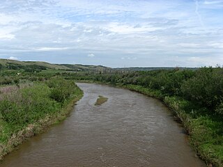
Nigel Creek is a short stream located in the Canadian Rockies of Alberta, Canada. It forms in the glacial meltwaters north of Sunwapta Pass and takes on streams flowing from Nigel Pass.

Canadian Rockies mountain range in Canada

The Canadian Rockies or Canadian Rocky Mountains comprise the Canadian segment of the North American Rocky Mountains. They are the eastern part of the Canadian Cordillera, which is a system of multiple ranges of mountains which runs from the Canadian Prairies to the Pacific Coast. The Canadian Rockies mountain system comprises the southeastern part of this system, lying between the Interior Plains of Alberta and Northeastern British Columbia on the east to the Rocky Mountain Trench of BC on the west. The southern end borders Idaho and Montana of the United States. In geographic terms the boundary is at the Canada/US border, but in geological terms it might be considered to be at Marias Pass in northern Montana. The northern end is at the Liard River in northern British Columbia.

Alberta Province of Canada

Alberta is a western province of Canada. With an estimated population of 4,067,175 as of 2016 census, it is Canada's fourth most populous province and the most populous of Canada's three prairie provinces. Its area is about 660,000 square kilometres (250,000 sq mi). Alberta and its neighbour Saskatchewan were districts of the Northwest Territories until they were established as provinces on September 1, 1905. The premier has been Rachel Notley since 2015.

Canada Country in North America

Canada is a country in the northern part of North America. Its ten provinces and three territories extend from the Atlantic to the Pacific and northward into the Arctic Ocean, covering 9.98 million square kilometres, making it the world's second-largest country by total area. Canada's southern border with the United States, stretching some 8,891 kilometres (5,525 mi), is the world's longest bi-national land border. Its capital is Ottawa, and its three largest metropolitan areas are Toronto, Montreal, and Vancouver. As a whole, Canada is sparsely populated, the majority of its land area being dominated by forest and tundra. Consequently, its population is highly urbanized, with over 80 percent of its inhabitants concentrated in large and medium-sized cities, with 70% of citizens residing within 100 kilometres (62 mi) of the southern border. Canada's climate varies widely across its vast area, ranging from arctic weather in the north, to hot summers in the southern regions, with four distinct seasons.

The creek flows South-Southeast, and parallels the Icefields Parkway for part of its course. It joins the North Saskatchewan River near the Big Bend. It plummets over Bridal Veil Falls before entering the North Saskatchewan. Nigel Creek is named after Nigel Vavasoeur, a packer who accompanied early climbing expeditions in the region. [1]

North Saskatchewan River river in Alberta and Saskatchewan

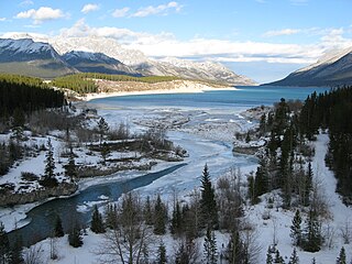
The North Saskatchewan River is a glacier-fed river that flows from the Canadian Rockies continental divide east to central Saskatchewan, where it joins with another major river to make up the Saskatchewan River. Its water flows eventually into the Hudson Bay.

Bridal Veil Falls (Banff) waterfall in Banff National Park, Alberta, Canada

Bridal Veil Fall is a waterfall in Banff National Park, Alberta, Canada. It originates in the Huntington Glacier on the slopes of Cirrus Mountain. Its waters drain into Nigel Creek, then into the North Saskatchewan River at the Big Bend of the Icefields Parkway.

See also

Related Research Articles

Geography of Alberta

Alberta is a Canadian province. Located in Western Canada, the province has an area of 661,190 square kilometres (255,290 sq mi) and is bounded to the south by the U.S. state of Montana along 49° north for 298 kilometres (185 mi); to the east at 110° west by the province of Saskatchewan for 1,223 kilometres (760 mi); and at 60° north the Northwest Territories for 644 kilometres (400 mi). The southern half of the province borders British Columbia along the Continental Divide of the Americas on the peaks of the Rocky Mountains, while the northern half borders British Columbia along the 120th meridian west.

Clearwater River (Alberta) river in Alberta, Canada

Clearwater is a river of southern Alberta, Canada. Situated entirely in the Canadian Rockies and the Rocky Mountain foothills of Alberta, it is a glacier fed upper reach tributary of the North Saskatchewan River. The upper reach of the Clearwater has become popular for equestrian travelers due to the natural setting along the river.

Red Deer River river in Alberta, Canada

The Red Deer River is a river in Alberta and a small portion of Saskatchewan, Canada. It is a major tributary of the South Saskatchewan River and is part of the larger Saskatchewan-Nelson system that empties into Hudson Bay.

Alberta Highway 1 highway in Alberta

Alberta Provincial Highway No. 1, commonly referred to as Highway 1, is a major east-west highway in Southern Alberta that forms a portion of the Trans-Canada Highway. It runs from the British Columbia border near Lake Louise through Calgary to the Saskatchewan border east of Medicine Hat. It spans approximately 534 km (332 mi) from Alberta's border with British Columbia in the west to its border with Saskatchewan in the east. The route is a divided expressway throughout the province with the exception of a section in central Calgary where it is an arterial thoroughfare. Twinning of the final 8.5 km (5.3 mi) of Highway 1 between Lake Louise and the British Columbia border was completed by Parks Canada and opened to traffic on June 12, 2014.

Maple Creek, Saskatchewan Town in Saskatchewan, Canada

Maple Creek is a town in Maple Creek Rural Municipality No. 111, Saskatchewan, Canada. The population was 2,084 at the 2016 Census.

Battle River river in Alberta and Saskatchewan, Canada

Battle River is a river in central Alberta and western Saskatchewan. It is a major tributary of the North Saskatchewan River.

Smoky River river in Canada

The Smoky River is a river in western Alberta, Canada. It is a major tributary of the Peace River. The descriptive name refers to the presence of "smouldering beds of coal in the riverbank" noted by the Cree Indians.

Howse River river in Canada

The Howse River is a tributary of the North Saskatchewan River in western Alberta, Canada.

Beaver River (Canada) river in Alberta and Saskatchewan

Beaver River is a large river in east-central Alberta and central Saskatchewan, Canada. It flows east through Alberta and Saskatchewan and then turns sharply north to flow into Lac Île-à-la-Crosse on the Churchill River which flows into Hudson Bay. The Alberta part is in the Cold Lake oil sands.

Brazeau River river in Alberta, Canada

The Brazeau River is a river in western Alberta, Canada. It is a major tributary of the North Saskatchewan River.

Central Alberta region in the province of Alberta, Canada

Central Alberta is a region located in the Canadian province of Alberta.

Albertas Rockies

Alberta's Rockies comprises the Canadian Rockies in the province of Alberta, Canada. It is a region on the southwestern part of the province, along the British Columbia border. It covers all but the south of Census Division 15.

Bighorn Dam

Bighorn Dam is a dam located in Clearwater County in west-central Alberta, Canada. It was built by Calgary Power in 1972, and led to the creation of Lake Abraham, Alberta's largest man-made lake. The dam and associated hydroelectric plant are managed by TransAlta.

Cline River river in Canada

The Cline River is a short river in western Alberta, Canada. It flows from Pinto Lake and joins the North Saskatchewan River at Lake Abraham in west-central Alberta.

Simpson Pass, el. 2,107 m (6,913 ft), is a mountain pass on the border between the Canadian provinces of Alberta and British Columbia, in the area of the Ball Range. It is the prominence col for Mount Ball on the Continental Divide in the vicinity of Sunshine Village ski resort. Simpson River and Simpson Pass are named after Sir George Simpson who first explored the area in 1841.

16 Avenue N road in Calgary, Alberta, Canada

16 Avenue N is a major road in Calgary, Alberta, that forms a 26.5-kilometre (16.5 mi) segment of Highway 1 and connects Calgary to Banff and Medicine Hat. It is a four to six-lane principal arterial expressway at its extremities, but is an urban arterial road between the Bow River and Bowness Road, and also between Crowchild Trail and Deerfoot Trail. Due to Calgary's quadrant system, it is known as 16 Avenue NW west of Centre Street and 16 Avenue NE to the east.

Saunders Creek, Alberta

Saunders Creek is a ghost town in west-central Alberta, Canada. Built as a coal mining community, the town existed from 1913 to 1954. It is located in the foothills of the Canadian Rockies near the David Thompson Highway, about 55 km west of the town of Rocky Mountain House. It was named for Saunders Creek, a small stream that runs immediately west of the townsite. The North Saskatchewan River flows nearby to the south.

Calgary Trail & Gateway Boulevard major thoroughfare in Edmonton

Calgary Trail and Gateway Boulevard are a pair of major arterial roadways in Edmonton, Alberta. Gateway Boulevard carries northbound traffic while Calgary Trail carries southbound traffic. From south of 31 Avenue, they form a two-way freeway separated by a median; for this portion, the roadway maintains the separate names for northbound and southbound traffic. Near 31 Avenue, Calgary Trail and Gateway Boulevard separate and become parallel one-way arterial roadways to Saskatchewan Drive, at the edge of the North Saskatchewan River valley. Designated as part of Highway 2 south of Whitemud Drive, it is Edmonton's main southern entrance and is both a major commuter route, connecting to the Edmonton International Airport and Leduc, as well as a regional connection to Central Alberta, and Calgary.

Alexandra River (Alberta)

The Alexandra River is a tributary of the North Saskatchewan River in Alberta, Canada. Its source is an unnamed lake at 1,563 metres (5,128 ft) of elevation, which is fed by the Alexandra Glacier. From there it flows for about 20 kilometres (12 mi) through a remote valley until it reaches its mouth at the North Saskatchewan River. There are no navigable roads in the river's valley, but a decommissioned hiking trail does follow the north bank upstream until the river's confluence with the Castleguard River. The trail eventually reaches the Castleguard Meadows, a revered but seldom-visited hiking destination.

References

  1. Karamitsanis, Aphrodite (1991). Place Names of Alberta, Volume 1. Calgary: University of Calgary Press, pg. 176

Coordinates: 52°09′56″N117°02′17″W / 52.16556°N 117.03806°W / 52.16556; -117.03806

Geographic coordinate system Coordinate system

A geographic coordinate system is a coordinate system that enables every location on Earth to be specified by a set of numbers, letters or symbols. The coordinates are often chosen such that one of the numbers represents a vertical position and two or three of the numbers represent a horizontal position; alternatively, a geographic position may be expressed in a combined three-dimensional Cartesian vector. A common choice of coordinates is latitude, longitude and elevation. To specify a location on a plane requires a map projection.