Nkonkobe Local Municipality

Last updated

Nkonkobe
Nkonkobe CoA.png
Map of the Eastern Cape with Nkonkobe highlighted.svg
Location in the Eastern Cape
Country South Africa
Province Eastern Cape
District Amathole
Seat Fort Beaufort
Wards 21
Government
[1]
  Type Municipal council
  MayorAnele Ntsangani
Area
  Total3,626 km2 (1,400 sq mi)
Population
 (2011) [2]
  Total127,115
  Density35/km2 (91/sq mi)
Racial makeup (2011)
[2]
   Black African 94.5%
   Coloured 4.0%
   Indian/Asian 0.2%
   White 1.0%
First languages (2011)
[2]
   Xhosa 90.1%
   Afrikaans 5.0%
   English 2.7%
  Other2.2%
Time zone UTC+2 (SAST)
Municipal codeEC127

Nkonkobe Local Municipality was an administrative area in the Amatole District of the Eastern Cape in South Africa. The municipality is named after the Winterberg mountain range, Nkonkobe in isiXhosa. [3] The seat, as well as most offices, of the Municipality are in Fort Beaufort, but the Council's chambers in Alice are generally used for council meetings, being better equipped. Other towns served by the municipality are Seymour, Balfour, Hogsback and Middledrift. After municipal elections on 3 August 2016 it was merged into the larger Raymond Mhlaba Local Municipality.

Contents

Main places

The 2001 census divided the municipality into the following main places: [4]

PlaceCodeArea (km2)Population
Alice 21601 21.978,009
Amagqunukwebe 21602 576.5735,694
Amagwala 21603 57.03854
Amajingqi 21604 161.5711,441
Amakhuze 21605 30.492,525
Balfour 21606 4.822,428
Bellvale 21607 2.00468
Bhofolo 21608 2.5412,098
Blinkwater 21609 5.171,041
Ekuphumuleni 21610 1.79436
Fort Beaufort 21611 46.1910,093
Gaga 21612 75.067,956
Gaika-Mbo 21613 69.152,796
Hogsback 21614 6.78648
Imingcangathelo 21615 24.564,849
Jingqi 21616 0.44190
Mhlangeni 21617 1.49116
Middledrift 21618 2.12665
Mlungisi 21619 1.23307
Moreson 21620 1.4884
Mpofu 21621 704.063,665
Ngqika 21622 18.991,580
Ngwalana 21623 32.971,922
Seymour 21625 2.211,552
Tamboekie Vlei 21626 1.18344
Tyhume 21627 116.928,238
Victoria East 21628 318.905,941
Remainder of the municipality 21624 1,437.772,727

Politics

The municipal council consisted of forty-one members elected by mixed-member proportional representation. Twenty-one councillors were elected by first-past-the-post voting in twenty-one wards, while the remaining twenty were chosen from party lists so that the total number of party representatives was proportional to the number of votes received. In the election of 18 May 2011 the African National Congress (ANC) won a majority of thirty-five seats on the council. The following table shows the results of the election. [5] [6]

PartyVotesSeats
WardListTotal %WardListTotal
ANC 29,34231,92361,26582.8201535
COPE 2,0722,2484,3205.8022
Democratic Alliance 1,8001,8343,6344.9022
Independent 3,3393,3394.511
PAC 7574881,2451.7011
UDM 192052240.3000
Total37,32936,69874,027100.0212041
Spoilt votes1,1841,7022,886

Related Research Articles

Randfontein Local Municipality Local municipality in Gauteng, South Africa

Randfontein Local Municipality was a local municipality in West Rand District Municipality, Gauteng, in South Africa. After municipal elections on 3 August 2016, it was merged with the Westonaria Local Municipality into the larger Rand West City Local Municipality.

Thaba Chweu Local Municipality Local municipality in Mpumalanga, South Africa

Thaba Chweu Local Municipality, is a municipality of South Africa, located in the Ehlanzeni District Municipality, Mpumalanga.

Albert Luthuli Local Municipality Local municipality in Mpumalanga, South Africa

Albert Luthuli Local Municipality is a South African local municipality situated in the Gert Sibande District Municipality, Grass and Wetlands region, of Mpumalanga. It was named after Albert Luthuli. Carolina is the seat of the municipality.

Msukaligwa Local Municipality Local municipality in Mpumalanga, South Africa

Msukaligwa Local Municipality is a South African local municipality situated in the Gert Sibande District Municipality, of Mpumalanga. Ermelo is the seat of the municipality.

Pixley ka Seme Local Municipality Local municipality in Mpumalanga, South Africa

Pixley Ka Seme Local Municipality is a South African local municipality situated in the Gert Sibande District Municipality, of Mpumalanga. Volksrust is the seat of the municipality.

Mkhondo Local Municipality Local municipality in Mpumalanga, South Africa

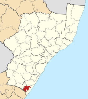
Mkhondo Local Municipality, is a South African local municipality situated in the Gert Sibande District Municipality, of Mpumalanga. Piet Retief is the seat of the municipality.

Molemole Local Municipality Local municipality in Limpopo, South Africa

Molemole Local Municipality, is located in the Capricorn District Municipality, of Limpopo province, South Africa. The seat of Molemole Local Municipality is Mogwadi.

Musina Local Municipality Local municipality in Limpopo, South Africa

Musina Local Municipality is located in the Vhembe District Municipality of Limpopo province, South Africa, and is the northernmost local municipality in South Africa. It borders on Botswana and Zimbabwe. The seat of Musina Local Municipality is Musina.

Maruleng Local Municipality Local municipality in Limpopo, South Africa

Maruleng Local Municipality is located in the Mopani District Municipality of Limpopo province, South Africa. The seat of Maruleng Local Municipality is Hoedspruit.

Ephraim Mogale Local Municipality Local municipality in Limpopo, South Africa

Ephraim Mogale Local Municipality is located in the Sekhukhune District Municipality of Limpopo province, South Africa. The seat of Ephraim Mogale Local Municipality is Marble Hall.

Steve Tshwete Local Municipality Local municipality in Mpumalanga, South Africa

Steve Tshwete Local Municipality is located in the Nkangala District Municipality of Mpumalanga province, South Africa. The seat of Steve Tshwete Local Municipality is Middelburg. The local municipality was one of the four to have passed the 2009-10 audit by the Auditor-General of South Africa, who deemed it to have a clean administration.

Mnquma Local Municipality Local municipality in Eastern Cape, South Africa

Mnquma Local Municipality is an administrative area in the Amatole District of the Eastern Cape in South Africa.

Ngqushwa Local Municipality Local municipality in Eastern Cape, South Africa

Ngqushwa Local Municipality is an administrative area in the Amatole District of the Eastern Cape in South Africa.

Umzimvubu Local Municipality Local municipality in Eastern Cape, South Africa

Umzimvubu Local Municipality is an administrative area in the Alfred Nzo District of Eastern Cape in South Africa.

Mhlontlo Local Municipality Local municipality in Eastern Cape, South Africa

Mhlontlo Local Municipality is an administrative area in the OR Tambo District of Eastern Cape in South Africa.

Ezinqoleni Local Municipality Former local municipality in KwaZulu-Natal, South Africa

Ezinqoleni Local Municipality was an administrative area in the Ugu District of KwaZulu-Natal in South Africa.

Tsolwana Local Municipality Former local municipality in Eastern Cape, South Africa

Tsolwana Local Municipality was an administrative area in the Chris Hani District of the Eastern Cape in South Africa. Tsolwana is an isiXhosa name which means "something with a sharp ending or a tip", referring the mountains around the whole area. After municipal elections on 3 August 2016 it was merged into the larger Enoch Mgijima Local Municipality.

Lukhanji Local Municipality Former local municipality in Eastern Cape, South Africa

Lukhanji Local Municipality was an administrative area in the Chris Hani District of the Eastern Cape in South Africa. Lukhanji is a Xhosa name for the mountain that runs from the eastern side of Queenstown to the western side. After municipal elections on 3 August 2016 it was merged into the larger Enoch Mgijima Local Municipality.

Walter Sisulu Local Municipality Local municipality in Eastern Cape, South Africa

Walter Sisulu Local Municipality is an administrative area in the Joe Gqabi District of the Eastern Cape in South Africa. The municipality was formed by the merging of Maletswai and Gariep Local Municipality immediately after the August 2016 Local Municipal Elections.

Raymond Mhlaba Local Municipality Local municipality in Eastern Cape, South Africa

Raymond Mhlaba Local Municipality is a local municipality of South Africa. It was established after the August 2016 local elections by the merging of Nkonkobe and Nxuba local municipalities.

References

  1. "Contact list: Executive Mayors". Government Communication & Information System. Archived from the original on 14 July 2010. Retrieved 22 February 2012.
  2. 1 2 3 "Statistics by place". Statistics South Africa. Retrieved 27 September 2015.
  3. South African Languages - Place names
  4. Lookup Tables - Statistics South Africa [ permanent dead link ]
  5. "Results Summary – All Ballots: Nkonkobe" (PDF). Independent Electoral Commission. Retrieved 24 November 2013.
  6. "Seat Calculation Detail: Nkonkobe" (PDF). Independent Electoral Commission. Retrieved 24 November 2013.

Coordinates: 32°47′S26°38′E / 32.783°S 26.633°E / -32.783; 26.633