October 2016 Central Italy earthquakes

Last updated

October 2016 Central Italy earthquakes
Shakemap Earthquake 30 Oct 2016 Italy.jpg
Shakemap for the 30 October quake
Italy relief location map.jpg
Bullseye1.png
UTC  time 
 A: 2016-10-26 17:10:37
 B: 2016-10-26 19:18:08
 C: 2016-10-30 06:40:18
ISC  event 
 A: 611830883
 B: 612638074
 C: 609624987
USGS-ANSS  
 A: ComCat
 B: ComCat
 C: ComCat
Local date 
 A: 26 October 2016
 B: 26 October 2016
 C: 30 October 2016
Local time 
 A: 19:10
 B: 21:18
 C: 08:40
Magnitude 
 A: 5.5 Mw
 B: 6.1 Mw
 C: 6.6 Mw
Depth10.0 km (6.2 mi)
Epicenter 42°51′18″N13°05′17″E / 42.855°N 13.088°E / 42.855; 13.088
Areas affected Central Italy
Max. intensity MMI XI (Extreme) [1]
Casualties3 deaths [2] [3]
Dozens injured [4]
100,000 homeless [5]

A series of major earthquakes struck Central Italy between the Marche and Umbria regions in October 2016. The third quake on 30 October was the largest in Italy in 36 years, since the 1980 Irpinia earthquake. [6]

Contents

Earthquakes

A magnitude 5.5 earthquake struck 8 km (5 mi) east southeast of Sellano on 26 October at 19:11 local time (17:11  UTC) [7] at a depth of 10 km (6 mi). [8] The earthquake was also felt in the city of Rome. [7] In the region of Marche some houses collapsed, Italian media reported. There were also power failures and the telephone lines were interrupted. [9]

A magnitude 6.1 intraplate earthquake struck 3 km (2 mi) west of Visso on 26 October at 21:18 local time (19:18  UTC). The earthquake, which occurred two months after a magnitude 6.2 earthquake in August, struck about 30 km (20 mi) to the northwest of the August earthquake's epicenter. [10] The civil protection, however, estimated the consequences less dramatically than feared. According to official data, a man died because he had suffered a heart attack as a result of the quake. [11]

A third large, shallow earthquake of USGS preliminary magnitude 6.6 struck 6 km (4 mi) north of Norcia at 07:40 local time (06:40 UTC) on 30 October. [12] Early news and social media reports showed heavy damage to some structures. The village of Arquata del Tronto was destroyed, [13] as were several heritage buildings. These include the Basilica of Saint Benedict in Norcia, [14] the Church of San Salvatore and other churches in Campi. [15] Two women died of sudden heart attacks during the quake. [16]

Shocks

Date / time
(UTC)
Magnitude TypeDepth
Hypocenter
Epicenter
Location Latitude Longitude
2016-10-26   17:10:365.5 Mw 8.7 km Macerata 42.880213.1275
2016-10-26   19:18:056.1 Mw 7.5 km Macerata 42.908713.1288
2016-10-26   21:42:014.5 Mw 9.5 km Macerata 42.861213.1283
2016-10-30   06:40:176.6 Mw 9.4 km Perugia 42.8413.11
2016-10-30   06:44:304.6 ML 10.0 km Perugia 42.850713.0715
2016-10-30   07:13:054.5 ML 10.8 km Rieti 42.698213.2347
2016-10-30   12:07:004.6 ML 9.7 km Perugia 42.844513.0775
2016-10-30   13:34:544.5 ML 9.2 km Perugia 42.803313.1653
2016-11-01   07:56:394.8 ML 10.0 km Macerata 43.0013.16
2016-11-03   00:35:014.8 ML 8.0 km Macerata 43.0313.05
October 2016 Central Italy earthquakes.svg
Magnitude of October 2016 Central Italy earthquakes.

Geological aspects

The quakes occurred in a seismic gap which is located between the areas hit by the 2016 August earthquake and the one in Umbria and Marche of 1997. In that gap no strong earthquake happened for more than 100 years [17] until 2016.

As the process of faulting along the chain of the Apennine Mountains is a relatively recent one in geological terms, starting 500,000 years ago, the faults are more irregular, so more shaking occurs due to foreshocks according to seismologist Ross Stein from Stanford University. In this case the destructive shock on 26 October was preceded by the foreshock by two hours, causing people to leave their homes and be safer when the larger shock occurred. [18] [19]

Comparisons with August 2016 earthquake

Italy-earthquakes-second-damaging-shock-rips-north-from-amatrice-3.jpg
The map to the left is dated 27 October, before the biggest shock of 30 October.
2016 Central Italy earthquake wide.svg
Earthquakes from August 2016 Central Italy earthquake.

See also

Related Research Articles

<span class="mw-page-title-main">Norcia</span> Comune in Umbria, Italy

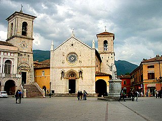
Norcia, traditionally known in English by its Latin name of Nursia, is a town and comune in the province of Perugia (Italy) in southeastern Umbria. Unlike many ancient towns, it is located in a wide plain abutting the Monti Sibillini, a subrange of the Apennines with some of its highest peaks, near the Sordo River, a small stream that eventually flows into the Nera. The town is popularly associated with the Valnerina. It is a member of I Borghi più belli d'Italia.

<span class="mw-page-title-main">Arquata del Tronto</span> Comune in Marche, Italy

Arquata del Tronto is a comune (municipality) in the Province of Ascoli Piceno, in the Marche region of Italy, located about 100 kilometres (62 mi) from Ancona. It is the only European municipality located partly within two natural parks: Gran Sasso national park and Cyblings mountains natural park.

<span class="mw-page-title-main">2009 L'Aquila earthquake</span> Earthquake in Abruzzo, Italy

An earthquake occurred in the region of Abruzzo, in central Italy, at 03:32 CEST on 6 April 2009. It was rated 5.8 or 5.9 on the Richter magnitude scale and 6.3 on the moment magnitude scale; its epicentre was near L'Aquila, the capital of Abruzzo, which together with surrounding villages suffered the most damage. There were several thousand foreshocks and aftershocks since December 2008, more than thirty of which had a Richter magnitude greater than 3.5.

<span class="mw-page-title-main">1997 Umbria and Marche earthquake</span> Mw5.7 and Mw6.0 earthquakes in central Italy

The 1997 Umbria and Marche earthquake occurred in the regions of Umbria and Marche, central Italy on the morning of 26 September. It was preceded by a foreshock almost as strong as the main quake. The foreshock occurred at 02:33 CEST, rated Mw5.7, and the second – the main shock – occurred at 11:40 CEST, rated Mw 6.0. Their epicentre was in Annifo. The mainshock was assigned X (Extreme) and foreshock VIII (Severe) on the Mercalli intensity scale.

<span class="mw-page-title-main">2011 Lorca earthquake</span> Moderate 5.1 Mw earthquake in Spain

The 2011 Lorca earthquake was a moderate 5.1 Mw earthquake that occurred 6:47 p.m. CEST on 11 May 2011, near the town of Lorca, causing significant localized damage in the Region of Murcia, Spain, and panic among locals, and displacing many from their homes. The quake was preceded by a magnitude 4.4 foreshock at 17:05, that inflicted substantial damage to many older structures in the area, including the historical Espolón Tower of Lorca Castle, the Hermitage of San Clemente and the Convent of Virgen de Las Huertas. Three people were killed by a falling cornice. A total of nine deaths have been confirmed, while dozens are reported injured. The earthquake was the worst to hit the region since a 5.0 Mw tremor struck west of Albolote, Granada in 1956.

The 1920 Garfagnana earthquake occurred on 7 September in Garfagnana and Lunigiana, both agricultural areas in the Italian Tuscany region. The quake hypocenter was located 14 kilometres (8.7 mi) beneath Villa Collemandina. The maximum felt intensity was rated as X (Extreme) on the Mercalli intensity scale, and 6.6 on the Richter magnitude scale. It was one of the most destructive seismic events recorded in the Apenninic region in the twentieth century. Due to good news coverage, availability of official documents on the damage and abundance of recordings from surveillance stations throughout Europe, it was regarded as a first-rate case study to improve knowledge of tectonics and macroseismic analysis.

The 1930 Senigallia earthquake struck the city of Senigallia in central Italy on 30 October. It occurred just a few months after the destructive 1930 Irpinia earthquake, which had caused over 1,400 casualties in the southern part of the country.

The 1936 Cansiglio earthquake occurred on 18 October in the region between the provinces of Belluno, Treviso and Pordenone, in northern Italy. It caused 19 deaths and an unknown number of injuries.

<span class="mw-page-title-main">2012 Northern Italy earthquakes</span> Severe earthquakes centered in Emilia-Romagna, Italy

In May 2012, two major earthquakes struck Northern Italy, causing 27 deaths and widespread damage. The events are known in Italy as the 2012 Emilia earthquakes, because they mainly affected the Emilia region.

<span class="mw-page-title-main">August 2016 Central Italy earthquake</span>

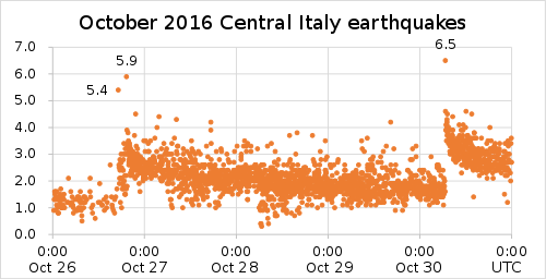
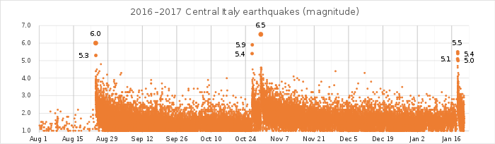
An earthquake, measuring 6.2 ± 0.016 on the moment magnitude scale, hit Central Italy on 24 August 2016 at 03:36:32 CEST. Its epicentre was close to Accumoli, with its hypocentre at a depth of 4 ± 1 km, approximately 75 km (47 mi) southeast of Perugia and 45 km (28 mi) north of L'Aquila, in an area near the borders of the Umbria, Lazio, Abruzzo and Marche regions. As of 15 November 2016, 299 people had been killed.

A series of four major earthquakes struck Central Italy between Abruzzo, Lazio, the Marche and Umbria regions on 18 January 2017.

The 2017 Ischia earthquake occurred in the island of Ischia, Campania, in southern Italy. The main shock occurred at 20:57 CEST on 21 August 2017, and was rated 3.9 Mw  or 4.2 mb  on the moment magnitude scale.

The 1990 Carlentini earthquake occurred off the Sicilian coast, 20 km east northeast from the town of Augusta, Sicily on 13 December at 01:24 local time. The moderately-sized earthquake measuring 5.6 on the moment magnitude scale (Mw ) resulted in the deaths of 19 people and caused at least 200 injuries. It also inflicted significant damage in the region, leaving 2,500 homeless.

The 2016 Alboran Sea earthquake struck offshore, north northeast of Al Hoceïma, Morocco in the Strait of Gibraltar on 25 January at 04:22:02 UTC, or roughly 05:22:02 West Africa Time. At its strongest in the Alboran Sea, the earthquake measured 6.3–6.4 on the moment magnitude scale (Mw ) at a shallow hypocenter depth of 12 km (7.5 mi). Assigned a maximum Modified Mercalli scale intensity of VI (Strong), the earthquake caused one fatality, injuries to at least 30 persons, and moderate damage in Morocco and Spain.

On December 5, 1456, the largest earthquake to occur on the Italian Peninsula struck the Kingdom of Naples. The earthquake had an estimated moment magnitude of Mw  7.19–7.4, and was centred near the town of Pontelandolfo in the present-day Province of Benevento, southern Italy. Earning a level of XI (Extreme) on the Modified Mercalli intensity scale, the earthquake caused widespread destruction in central and southern Italy. An estimated 30,000–70,000 people were killed. It was followed by two strong Mw  7.0 and 6.0 earthquakes to the north on December 30.

A series of four mainshocks struck Calabria on March 27–28 and June 9, 1638. The first three earthquakes had moment magnitudes estimated to be Mw 6.6–7.1. On June 9, another mainshock estimated at Mw  6.7 struck the same region, causing further damage and casualties. The four earthquakes resulted in as many as 30,000 fatalities.

The second shock in the 1962 Irpinia earthquake sequence was the largest and most destructive in a series of earthquakes in the southern Apennines. It occurred on 21 August at 18:19 CET, measuring Mw 6.15 and assigned a maximum intensity of IX (Violent). It was preceded by an Mw  5.68 foreshock, and followed by a 5.34 aftershock. The earthquakes resulted in nearly 20 fatalities and significant property losses.

References

  1. Paolo Galli; Sergio Castenetto; Edoardo Peronace (2017). "The Macroseismic Intensity Distribution of the 30 October 2016 Earthquake in Central Italy (Mw 6.6): Seismotectonic Implications". Tectonics. 36 (10): 2179–2191. Bibcode:2017Tecto..36.2179G. doi:10.1002/2017TC004583. S2CID   134166952.
  2. "Terremoto, morto per infarto a Tolentino". www.ansa.it. 27 October 2016. Retrieved 2 November 2016.
  3. Terremoto, Bevagna e Norcia, due donne morte di infarto, un'altra dispersa
  4. Il terremoto delle 7,40: una ventina di feriti, 28mila gli sfollati
  5. Terremoto di 6,5 tra Norcia e Preci. Mai così forte dall'80. Nessuna vittima. "Si temono 100mila sfollati"
  6. Dewan, Angela; Blau, Max (30 October 2016). "Italy earthquake: 6.6-magnitude tremor rocks nation's center". CNN. Retrieved 30 October 2016.
  7. 1 2 Nachrichtenfernsehen, n-tv. "Stärke von 5,4 auf der Richterskala: Starkes Erdbeben erschüttert Mittelitalien". n-tv.de. Retrieved 26 October 2016.
  8. "M5.5 - 8km ESE of Sellano, Italy". United States Geological Survey. 26 October 2016. Retrieved 26 October 2016.
  9. Switzerland, St. Galler Tagblatt AG. "Schweres Erdbeben in Mittelitalien – Ausmass unklar". St. Galler Tagblatt Online (in German). Retrieved 26 October 2016.
  10. "M6.1 - 2km NNW of Visso, Italy". United States Geological Survey. 26 October 2016. Retrieved 26 October 2016.
  11. "Ein Toter nach schweren Erdbeben in Mittelitalien". www.t-online.de. Retrieved 27 October 2016.
  12. "M6.6 - 6km N of Norcia, Italy". United States Geological Survey. 30 October 2016. Retrieved 30 October 2016.
  13. "Terremoto, Arquata del Tronto non esiste più" (in Italian). Il Messagero. 30 October 2016. Retrieved 30 October 2016.
  14. "Italy earthquake: 6.6 magnitude shock felt in Rome". The Guardian. 30 October 2016. Retrieved 30 October 2016.
  15. "Italy quake church collapse caught on camera". Times of Malta . 27 October 2016. Archived from the original on 22 February 2017.
  16. "Terremoto, Bevagna e Norcia, due donne morte di infarto, un'altra dispersa" . Retrieved 3 November 2016.
  17. since there is that 1879 quake in the map, not more offside than the actual quake its safer to say so, instead telling the 157 years from source spiegel.de
  18. Germany, SPIEGEL ONLINE, Hamburg (27 October 2016). "Erdbeben in Italien: Ein geologischer Zufall rettete Tausende". Der Spiegel.{{cite news}}: CS1 maint: multiple names: authors list (link)
  19. Ross Stein; Volkan Sevilgen (26 October 2016). "Italy Earthquakes: Second damaging shock rips north from Amatrice". Temblor.net. Retrieved 30 October 2016.