Okolona, Mississippi

Last updated

Okolona, Mississippi
Flag of Okolona, Mississippi.png
Seal of Okolona, Mississippi.png
Chickasaw County Mississippi Incorporated and Unincorporated areas Okolona Highlighted.svg
Location of Okolona, Mississippi
Usa edcp location map.svg
Red pog.svg
Okolona, Mississippi
Location in the United States
Coordinates: 34°0′21″N88°45′2″W / 34.00583°N 88.75056°W / 34.00583; -88.75056
Country United States
State Mississippi
County Chickasaw
Government
  MayorEldridge Lowe
Area
[1]
  Total7.19 sq mi (18.63 km2)
  Land7.18 sq mi (18.59 km2)
  Water0.02 sq mi (0.04 km2)
Elevation
338 ft (103 m)
Population
 (2020)
  Total2,513
  Density350.15/sq mi (135.18/km2)
Time zone UTC-6 (Central (CST))
  Summer (DST) UTC-5 (CDT)
ZIP code
38860
Area code 662
FIPS code 28-53680
GNIS feature ID0694253
Website www.cityofokolona.com
A postcard for Wilson Park in Okolona, c. 1930-1945 Wilson Park, Okolona Miss..jpg
A postcard for Wilson Park in Okolona, c. 19301945

Okolona is a city in and one of the two county seats of Chickasaw County, Mississippi, United States. [2] It is located near the eastern border of the county. The population was 2,692 at the 2010 census. [3] It had a large furniture industry and the Wilson Park resort. [4]

Contents

History

Okolona was named as Rose Hill in 1845 early in its settlement, but residents later discovered that another location had this name. When a US post office was established here in 1850, a new name was needed to avoid confusion in mail delivery. According to the Okolona Area Chamber of Commerce, Colonel Josiah N. Walton, postmaster of nearby Aberdeen, Mississippi, remembered an encounter with a Chickasaw warrior years earlier. The man's name was Oka-laua, meaning peaceful, yellow, or blue water. Walton renamed Rose Hill as Okolona in his honor.

Due to the destruction brought to the area by the Civil War, few structures from the antebellum period remain. The Elliott-Donaldson House, constructed in 1850, survives and was added to the National Register of Historic Places in 1980. A few other homes have also survived.

In the mid nineteenth century, Okolona and the surrounding Black Prairie, sometimes called the Black Belt or Prairie Belt, became what has been called the "Bread Basket of the Confederacy". The area was part of the original Cotton Belt of Mississippi well before the more famous Delta region gained fame for major cotton production.

The Mobile and Ohio Railroad completed its tracks though Okolona in 1859, making the town a center for the ginning of cotton and its shipment to markets. The town grew along Main Street as a result of the railroad. Most commercial buildings from this period, including the depot, were burned during the Civil War.

Civil War era

Five skirmishes or battles between Union and Confederate forces occurred in and around Okolona. The eponymous Battle of Okolona occurred in February 1864. In a running cavalry clash between Confederate General Nathan Bedford Forrest and Union General William Sooy Smith, the Federals were defeated just north and west of town. General Forrest's brother, Jeffery, was killed in the engagement.

Okolona College

Okolona College was an historically black college served African Americans 19021965. Today it is central to the Okolona College Historic District.

Geography

According to the United States Census Bureau, the city has a total area of 6.66 square miles (17.26 km2), of which 6.64 square miles (17.21 km2) is land and 0.02 square miles (0.04 km2), or 0.23%, is water. [3]

As highways were built, they passed through the city, connecting it with other towns. This is the location of the junction of former U.S. Route 45 Alternate (Church Street) and Mississippi Highway 32 (Monroe Avenue). US-45A now bypasses the town to the east as a four-lane divided highway.

Demographics

Historical population
CensusPop.Note
1870 1,410
1880 1,85831.8%
1890 2,09913.0%
1900 2,1773.7%
1910 2,58418.7%
1920 3,85249.1%
1930 2,235−42.0%
1940 2,117−5.3%
1950 2,1672.4%
1960 2,62221.0%
1970 3,00214.5%
1980 3,40913.6%
1990 3,267−4.2%
2000 3,056−6.5%
2010 2,692−11.9%
2020 2,513−6.6%
U.S. Decennial Census [5]

2020 census

Okolona Racial Composition [6]
RaceNum.Perc.
White 49019.5%
Black or African American 1,92276.48%
Native American 30.12%
Asian 30.12%
Other/Mixed 642.55%
Hispanic or Latino 311.23%

As of the 2020 United States Census, there were 2,513 people, 1,164 households, and 645 families residing in the city.

2010 census

As of the 2010 United States Census, there were 2,692 people living in the city. 70.0% were African American, 27.9% White, 0.0% Native American, 0.1% Asian, 0.9% from some other race and 1.1% of two or more races. 1.3% were Hispanic or Latino of any race.

2000 census

As of the census of 2000, there were 3,056 people, 1,177 households, and 786 families living in the city. The population density was 481.8 inhabitants per square mile (186.0/km2). There were 1,315 housing units at an average density of 207.3 per square mile (80.0/km2). The racial makeup of the city was 39.40% White, 59.62% African American, 0.03% Native American, 0.13% Asian, 0.13% from other races, and 0.69% from two or more races. 1.05% of the population were Hispanic or Latino of any race.

There were 1,177 households, out of which 33.8% had children under the age of 18 living with them, 35.6% were married couples living together, 28.1% had a female householder with no husband present, and 33.2% were non-families. 30.2% of all households were made up of individuals, and 14.8% had someone living alone who was 65 years of age or older. The average household size was 2.54 and the average family size was 3.16.

In the city, the population was spread out, with 30.0% under the age of 18, 8.9% from 18 to 24, 24.7% from 25 to 44, 22.0% from 45 to 64, and 14.5% who were 65 years of age or older. The median age was 34 years. For every 100 females, there were 77.2 males. For every 100 females age 18 and over, there were 71.6 males.

The median income for a household in the city was $20,000, and the median income for a family was $32,147. Males had a median income of $26,217 versus $17,276 for females. The per capita income for the city was $11,486. 35.4% of the population and 29.7% of families were below the poverty line. Of the total people living in poverty, 55.4% were under the age of 18 and 20.9% were 65 or older.

Education

Okolona is served by the Okolona Municipal Separate School District. On February 19, 2010, the Mississippi State Board of Education voted unanimously to abolish the school district. State Superintendent of Education Tom Burnham said the conservator of the district will be Mike Vinson. [7]

Notable people

Related Research Articles

<span class="mw-page-title-main">Pontotoc County, Oklahoma</span> County in Oklahoma, United States

Pontotoc County is in the south central part of Oklahoma. As of the 2020 census, the population was 38,065. Its county seat is Ada. The county was created at statehood from part of the Chickasaw Nation in Indian Territory. It was named for a historic Chickasaw tribal area in Mississippi. According to the Encyclopedia of Oklahoma History and Culture, Pontotoc is usually translated "cattail prairie" or "land of hanging grapes."

<span class="mw-page-title-main">Marshall County, Oklahoma</span> County in Oklahoma, United States

Marshall County is a county located on the south central border of Oklahoma. As of the 2020 census, the population was 15,312. Its county seat is Madill. The county was created at statehood in 1907 from the former Pickens County of the Chickasaw Nation. It was named to honor the maiden name of the mother of George Henshaw, a member of the 1906 Oklahoma Constitutional Convention. The county and its cities are part of the Texoma region.

<span class="mw-page-title-main">Tishomingo County, Mississippi</span> County in Mississippi, United States

Tishomingo County is a county located in the northeastern corner of the U.S. state of Mississippi. As of the 2020 census, the population was 18,850. Its county seat is Iuka.

<span class="mw-page-title-main">Tippah County, Mississippi</span> County in Mississippi, United States

Tippah County is a county located on the northern border of the U.S. state of Mississippi. As of the 2020 census, the population was 21,815. Its county seat is Ripley. The name "Tippah" is derived from a Chickasaw language word meaning "cut off." It was taken from the creek of the same name that flows across much of the original county from northeast to southwest before emptying into the Tallahatchie River. The creek probably was so named because it, and the ridges on either side, "cut off" the western part of the region from the eastern portion.

<span class="mw-page-title-main">Pontotoc County, Mississippi</span> County in Mississippi, United States

Pontotoc County is a county located in the U.S. state of Mississippi. As of the 2020 census, the population was 31,184. Its county seat is Pontotoc. It was created on February 9, 1836, from lands ceded to the United States under the Chickasaw Cession. Pontotoc is a Chickasaw word meaning "land of hanging grapes". The original Natchez Trace and the current-day Natchez Trace Parkway both pass through the southeast corner of Pontotoc County.

<span class="mw-page-title-main">Panola County, Mississippi</span> County in Mississippi, United States

Panola County is a county located in the U.S. state of Mississippi. As of the 2020 census, the population was 33,208. Its county seats are Sardis and Batesville. The county is located just east of the Mississippi Delta in the northern part of the state. It is bisected by the Tallahatchie River flowing to the southwest; travel difficulties because of the river resulted in two county seats being established.

<span class="mw-page-title-main">Monroe County, Mississippi</span> County in Mississippi, United States

Monroe County is a county on the northeast border of the U.S. state of Mississippi next to Alabama. As of the 2020 census, the population was 34,180. Its county seat is Aberdeen.

<span class="mw-page-title-main">Chickasaw County, Mississippi</span> County in Mississippi, United States

Chickasaw County is a county located in the U.S. state of Mississippi. As of the 2020 census, the population was 17,106. Its county seats are Houston and Okolona. The county is named for the Chickasaw people, who lived in this area for hundreds of years. Most were forcibly removed to Indian Territory in the 1830s, but some remained and became citizens of the state and the United States.

<span class="mw-page-title-main">Calhoun County, Mississippi</span> County in Mississippi, United States

Calhoun County is a county located in the U.S. state of Mississippi. As of the 2020 census, the population was 13,266. Its county seat is Pittsboro. The county is named after John C. Calhoun, the U.S. Vice President and U.S. Senator from South Carolina.

<span class="mw-page-title-main">Chickasaw, Alabama</span> City in Alabama, United States

Chickasaw is a city in Mobile County, Alabama, United States. As of the 2020 census the population was 6,457, up from 6,106 at the 2010 census. It is part of the Mobile metropolitan area.

<span class="mw-page-title-main">Houston, Mississippi</span> City in Mississippi, United States

Houston is a city and one of two county seats of Chickasaw County, in northeastern Mississippi, United States. The population was 3,623 at the 2010 census.

<span class="mw-page-title-main">New Houlka, Mississippi</span> Town in Mississippi, United States

New Houlka, also referred to simply as Houlka, is a town in Chickasaw County, Mississippi, United States. It was founded in 1904 to take advantage of a railway line of the Gulf and Ship Island Railroad. Residents moved their buildings over from the original settlement, now referred to as "Old Houlka", located to the west. The population was 626 at the 2010 census.

<span class="mw-page-title-main">Hernando, Mississippi</span> City in Mississippi, United States

Hernando is the county seat of DeSoto County, on the northwestern border of Mississippi, United States. The population was 17,138 according to the 2020 census records. DeSoto County is the second-most-populous county in the Memphis metropolitan area, which includes counties in Tennessee, Arkansas and Mississippi.

<span class="mw-page-title-main">Aberdeen, Mississippi</span> City in Mississippi, United States

Aberdeen is the county seat of Monroe County, Mississippi, United States. As of the 2020 census, the population was 4,961, down from 5,612 in 2010.

<span class="mw-page-title-main">Booneville, Mississippi</span> City in Mississippi, United States

Booneville is a city in the U.S. state of Mississippi and is the county seat of Prentiss County. It is located in the hilly North Mississippi region, and ecologically is part of the Southeastern Plains region.

<span class="mw-page-title-main">Senatobia, Mississippi</span> City in Mississippi, United States

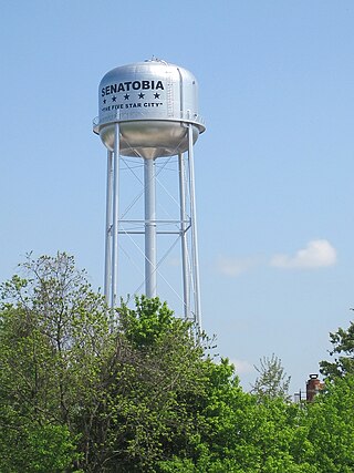
Senatobia is a city in and the county seat of Tate County, Mississippi, United States, and is the 16th largest municipality in the Memphis Metropolitan Area. The population was 8,165 at the 2010 census. Senatobia is home to Northwest Mississippi Community College, a state community college providing two-year academic and technical degree programs. Also located in Senatobia is the Baddour Center, a residential care facility for intellectually disabled adults.

<span class="mw-page-title-main">Wyatt, Missouri</span> City in Missouri, United States

Wyatt is a city in Mississippi County, Missouri, United States. The population was 219 at the 2020 census, down from 319 in 2010. It is the easternmost city west of the Mississippi River.

<span class="mw-page-title-main">Tishomingo, Oklahoma</span> City in Oklahoma

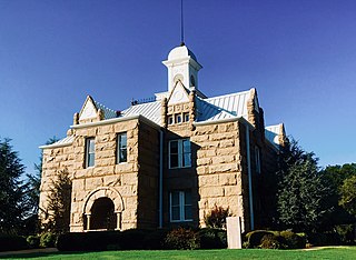
Tishomingo is the largest city in, and the county seat of, Johnston County, Oklahoma, United States. The population was 3,034 at the 2010 census, a decline of 4.1 percent from the figure of 3,162 in 2000. It was the first capital of the Chickasaw Nation, from 1856 until Oklahoma statehood in 1907. The city is home to Murray State College, a community college with an annual enrollment of 3,015 students. Tishomingo is part of the Texoma region.

Milton is a census-designated place (CDP) in the town of Milton in Saratoga County, New York, United States. The population was 2,692 at the 2000 census.

<span class="mw-page-title-main">Eupora, Mississippi</span> City in Mississippi, United States

Eupora is the largest city in Webster County, central Mississippi. The population was 2,197 at the 2010 census.

References

  1. "2020 U.S. Gazetteer Files". United States Census Bureau. Retrieved July 24, 2022.
  2. "Find a County". National Association of Counties. Archived from the original on May 31, 2011. Retrieved June 7, 2011.
  3. 1 2 "Geographic Identifiers: 2010 Demographic Profile Data (G001): Okolona city, Mississippi". U.S. Census Bureau, American Factfinder. Archived from the original on February 12, 2020. Retrieved October 3, 2014.
  4. "Our History".
  5. "Census of Population and Housing". Census.gov. Retrieved June 4, 2015.
  6. "Explore Census Data". data.census.gov. Retrieved December 8, 2021.
  7. [ dead link ]
  8. Martin Rywell; Charles Harris Wesley (1974). Afro-American Encyclopedia. Educational Book Publishers. p. 367.
  9. Mississippi. Department of Archives and History (1912). The Official and Statistical Register of the State of Mississippi. Department of Archives and History. p. 364.
  10. Jere Nash; Andy Taggart (2006). Mississippi Politics: The Struggle for Power, 1976-2006. Univ. Press of Mississippi. p. 321. ISBN   978-1-60473-140-8.
  11. Nancy Capace (January 1, 2001). Encyclopedia of Mississippi. Somerset Publishers, Inc. p. 406. ISBN   978-0-403-09603-9.
  12. "Russell Jolly's Biography". Project Vote Smart. Retrieved May 19, 2020.
  13. Raspberry, William (December 26, 2005). "What I'll Do Next". The Washington Post. Retrieved March 14, 2007.