Tylertown, Mississippi

Last updated

Tylertown, Mississippi
Walthall County Mississippi Courthouse.jpg
Walthall County Courthouse in Tylertown
Walthall County Mississippi Incorporated and Unincorporated areas Tylertown Highlighted.svg
Location of Tylertown, Mississippi
Usa edcp location map.svg
Red pog.svg
Tylertown, Mississippi
Location in the United States
Coordinates: 31°6′58″N90°8′34″W / 31.11611°N 90.14278°W / 31.11611; -90.14278
Country United States
State Mississippi
County Walthall
Area
[1]
  Total3.29 sq mi (8.51 km2)
  Land3.28 sq mi (8.49 km2)
  Water0.01 sq mi (0.02 km2)
Elevation
295 ft (90 m)
Population
 (2020)
  Total1,515
  Density462.03/sq mi (178.38/km2)
Time zone UTC-6 (Central (CST))
  Summer (DST) UTC-5 (CDT)
ZIP code
39667
Area code 601
FIPS code 28-75160
GNIS feature ID0690939
Website http://www.co.walthall.ms.us/town-of-tylertown.html

Tylertown is a town in and the county seat of Walthall County, Mississippi, United States. [2] The population was 1,609 at the 2010 census.

Contents

History

The town of Tylertown was first known as the Magee Settlement. It was settled by emigrants of the Magee and Thornhill families, who came from South Carolina. J. Thornhill acquired the first tract of land for the settlement on September 20, 1816, after Native Americans were pushed out of the area. Cullen Conerly went there in 1850 and bought out the Garland Hart store and established a post office which was called Conerly's post office. The store and post office served as the social center of the community for over a half century.

The town bore the name Conerly's from 1848 to 1879. It was renamed as Tyler Town in honor of William G. Tyler;[ who? ] the name was shortened to one word in 1894. Cullen Conerly sold his mercantile interest to his brother-in-law Benjamin Lampton. He laid the foundation of the mercantile business of Tylertown. [3] Tylertown was part of Pike County until 1912, when Walthall County was formed from Pike and Marion counties. The Tylertown Times (local newspaper) was started in 1907. Tylertown Insurance Agency, Inc. has been serving Tylertown's insurance needs since 1924. Luter's Supply, established in 1944, is a retail center for tubs, showers, and whirlpools. Jones Furniture opened in 1939. Tylertown's oldest pharmacy, Pigott's Drug Store, has been around since 1919. WTYL radio station came to Tylertown in 1969.

In interesting story about Tylertown and Walthall County was related in Maury Klein's book "A Call to Arms" (Bloomsbury Press, Paperback edition, 2015). It seems that during World War II, the production and growing of food became problematic as both the United States and its allies were in need of great amounts of food. Production was lagging and crops were rotting in the fields for lack of crop pickers - farm laborers either marched off to war or to factories where wages were far superior to those earned picking cotton - and the need for more of everything was needed. Walthall County responded to the call to grow more of everything. The farmers left behind produced what was termed "barn-bursting harvests, including 23 percent more cotton, 146 percent more hay, 110 percent more eggs, and a whopping 619 percent more truck crops. To celebrate, they decided to hold a "Food for Freedom Thanksgiving" early in October in Tylertown (population 1,100) the county seat and only post office".

According to Klein, the farming crowd came together in Tylertown and came bearing 5,000 fried chickens, 350 turkeys and enough food to feed a small army. Claude Wickard, head of the Food Requirements Committee, appeared in Tylertown that day and extolled the virtues of the small farmer and told them that their endeavors were the "only road that leads to victory". Klein, p. 449.

Geography

Tylertown is located at 31°6′58″N90°8′34″W / 31.11611°N 90.14278°W / 31.11611; -90.14278 (31.116209, -90.142817). [4]

According to the United States Census Bureau, the town has a total area of 3.1 square miles (8.0 km2), of which 3.0 square miles (7.8 km2) is land and 0.33% is water.

Demographics

Historical population
CensusPop.Note
1910 795
1920 1,11640.4%
1930 1,102−1.3%
1940 1,37624.9%
1950 1,331−3.3%
1960 1,53215.1%
1970 1,73613.3%
1980 1,97613.8%
1990 1,938−1.9%
2000 1,910−1.4%
2010 1,609−15.8%
2020 1,515−5.8%
U.S. Decennial Census [5]

2020 census

Tylertown racial composition [6]
RaceNum.Perc.
White (non-Hispanic)82254.26%
Black or African American (non-Hispanic)60940.2%
Native American 50.33%
Asian 251.65%
Pacific Islander 10.07%
Other/Mixed 291.91%
Hispanic or Latino 241.58%

As of the 2020 United States census, there were 1,515 people, 618 households, and 382 families residing in the town.

2000 census

As of the census [7] of 2000, there were 1,910 people, 707 households, and 461 families residing in the town. The population density was 625.9 inhabitants per square mile (241.7/km2). There were 825 housing units at an average density of 270.3 per square mile (104.4/km2). The racial makeup of the town was 56.34% White, 41.41% African American, 0.16% Native American, 0.84% Asian, 0.47% from other races, and 0.79% from two or more races. Hispanic or Latino of any race were 1.10% of the population.

There were 707 households, out of which 31.5% had children under the age of 18 living with them, 40.5% were married couples living together, 21.6% had a female householder with no husband present, and 34.7% were non-families. 32.2% of all households were made up of individuals, and 18.4% had someone living alone who was 65 years of age or older. The average household size was 2.47 and the average family size was 3.15.

In the town, the population was spread out, with 26.6% under the age of 18, 9.1% from 18 to 24, 21.6% from 25 to 44, 20.2% from 45 to 64, and 22.6% who were 65 years of age or older. The median age was 39 years. For every 100 females, there were 75.6 males. For every 100 females age 18 and over, there were 69.5 males.

The median income for a household in the town was $20,515, and the median income for a family was $30,125. Males had a median income of $30,625 versus $16,094 for females. The per capita income for the town was $13,712. About 28.9% of families and 32.3% of the population were below the poverty line, including 48.0% of those under age 18 and 18.2% of those age 65 or over.

Education

Tylertown is served by the Walthall County School District. The schools are Tylertown High School, and Salem Attendance Center.

Notable people

Related Research Articles

<span class="mw-page-title-main">Montgomery County, Alabama</span> County in Alabama, United States

Montgomery County is a county located in the U.S. state of Alabama. As of the 2020 census, its population was 228,954, making it the seventh-most populous county in Alabama. Its county seat is Montgomery, the state capital. Montgomery County is included in the Montgomery Metropolitan Statistical Area.

<span class="mw-page-title-main">Pike County, Alabama</span> County in Alabama, United States

Pike County is located in the U.S. state of Alabama. As of the 2020 census the population was 33,009. Its county seat is Troy. Its name is in honor of General Zebulon Pike, of New Jersey, who led an expedition to southern Colorado and encountered Pikes Peak in 1806.

<span class="mw-page-title-main">Webster County, Mississippi</span> County in Mississippi, United States

Webster County is a county located in center of the U.S. state of Mississippi, bordered on the south by the Big Black River. As of the 2020 census, the population was 9,926.

<span class="mw-page-title-main">Walthall County, Mississippi</span> County in Mississippi, United States

Walthall County is a county located in the U.S. state of Mississippi. As of the 2020 census, the population was 13,884. Its county seat is Tylertown. The county is named after Civil War Confederate general and Mississippi Senator Edward C. Walthall.

<span class="mw-page-title-main">Pike County, Mississippi</span> County in Mississippi, United States

Pike County is a county located on the southwestern border of the U.S. state of Mississippi. As of the 2020 census, the population was 40,324. The county seat is Magnolia. Pike County is named for explorer Zebulon Pike. Pike County is part of the McComb, MS Micropolitan Statistical Area.

<span class="mw-page-title-main">Lincoln County, Mississippi</span> County in Mississippi, United States

Lincoln County is a county located in the U.S. state of Mississippi. As of the 2020 census, the population was 34,907. Its county seat is Brookhaven.

<span class="mw-page-title-main">Crowley County, Colorado</span> County in Colorado, United States

Crowley County is a county in Colorado. As of the 2020 census, the population was 5,922. The county seat is Ordway.

<span class="mw-page-title-main">Goshen, Alabama</span> Town in Alabama, United States

Goshen is a town in Pike County, Alabama, United States. At the 2010 census the population was 266, down from 300 in 2000. It incorporated in 1907.

Stetson is a town in Penobscot County, Maine, United States. The population was 1,186 at the 2020 census. It was named after its first proprietor, Amasa Stetson. His brother Simeon Stetson originally settled here as well, but moved to nearby Hampden in 1803. Simeon's sons Charles, George, and Isaiah founded a powerful mercantile and political family in Bangor.

<span class="mw-page-title-main">Morgan City, Mississippi</span> Town in Mississippi, United States

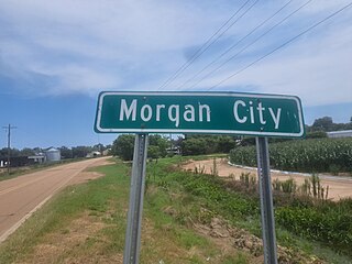
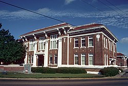
Morgan City, Mississippi is a town in Leflore County along Mississippi Highway 7. The population was 255 at the 2010 census, down from 305 at the 2000 census. It is part of the Greenwood, Mississippi micropolitan area.

<span class="mw-page-title-main">Sardis, Mississippi</span> Town in Mississippi, United States

Sardis is a town in Panola County, Mississippi. As of the 2020 census, the town population was 1,748. Sardis is one of two county seats for Panola County; the other is Batesville, on the south side of the Tallahatchie River.

<span class="mw-page-title-main">Osyka, Mississippi</span> Town in Mississippi, United States

Osyka is a town in Pike County, Mississippi, United States. It is located on the Mississippi–Louisiana state line. The population was 440 at the 2010 census. It is part of the McComb, Mississippi Micropolitan Statistical Area. The peak of its population was in 1910.

<span class="mw-page-title-main">Summit, Mississippi</span> Town in Mississippi, United States

Summit is a town in Pike County, Mississippi, United States. The population was 1,705 at the 2010 census. It is part of the McComb, Mississippi Micropolitan Statistical Area.

<span class="mw-page-title-main">Braxton, Mississippi</span> Village in Mississippi, United States

Braxton is a village in Simpson County, Mississippi, United States. The village's population was 181 at the 2000 census. It is part of the Jackson, Mississippi Metropolitan Statistical Area. Its zip code is 39044.

<span class="mw-page-title-main">Walthall, Mississippi</span> Village in Mississippi, United States

Walthall is a village in Webster County, Mississippi. The population was 144 at the 2010 census. It is the county seat of Webster County, designated in 1876.

<span class="mw-page-title-main">Coffeeville, Mississippi</span> Town in Mississippi, United States

Coffeeville is a town in and one of two county seats of Yalobusha County, Mississippi, United States. The population was 905 at the 2010 census. It is named after John Coffee (1772–1833), a planter and military leader. The minor American Civil War Battle of Coffeeville took place near here in December 1862.

<span class="mw-page-title-main">Horn Lake, Mississippi</span> City in Mississippi, United States

Horn Lake is a city in DeSoto County, Mississippi, United States. It is located 1.2 mi (1.9 km) south of Memphis, Tennessee. The population was 26,736 at the 2020 census, making it the 13th most populous city in Mississippi.

<span class="mw-page-title-main">Lena, Mississippi</span> Town in Mississippi, United States

Lena is a town in Leake County, Mississippi, United States. The population was 148 at the 2010 census. The center of population of Mississippi is located in Lena.

<span class="mw-page-title-main">Pike, New York</span> Town in New York, United States

Pike is an incorporated town in Wyoming County, New York. The population was 1,114 at the 2010 census.

<span class="mw-page-title-main">McComb micropolitan area</span> Micropolitan area in Mississippi, U.S.

The McComb Micropolitan Statistical Area is a micropolitan area in southwestern Mississippi that includes Pike and Walthall Counties, which had a combined population of 53,124 as of the 2020 census.

References

  1. "2020 U.S. Gazetteer Files". United States Census Bureau. Retrieved July 24, 2022.
  2. "Find a County". National Association of Counties. Retrieved June 7, 2011.
  3. Pike County Mississippi 1798-1876 Pioneer Families and Confederate Soldiers by Luke W. Conerly, 1909
  4. "US Gazetteer files: 2010, 2000, and 1990". United States Census Bureau. February 12, 2011. Retrieved April 23, 2011.
  5. "Census of Population and Housing". Census.gov. Retrieved June 4, 2015.
  6. "Explore Census Data". data.census.gov. Retrieved December 16, 2021.
  7. "U.S. Census website". United States Census Bureau . Retrieved January 31, 2008.
  8. "U.S. Ambassador to Mozambique: Who Is H. Dean Pittman?". AllGov. Retrieved February 9, 2018.