
The London Borough of Southwark in South London forms part of Inner London and is connected by bridges across the River Thames to the City of London and London Borough of Tower Hamlets. It was created in 1965 when three smaller council areas amalgamated under the London Government Act 1963. All districts of the area are within the London postal district. It is governed by Southwark London Borough Council.

Crystal Palace is in South Norwood South London, and named after the Crystal Palace Exhibition building which stood in the area from 1854, until it was destroyed by fire in 1936. About 7 miles (11 km) southeast of Charing Cross, it includes one of the highest points in London, at 367 feet (112 m), offering views over the capital.

Peckham is a district in south-east London, within the London Borough of Southwark. It is 3.5 miles (5.6 km) south-east of Charing Cross. At the 2001 Census the Peckham ward had a population of 14,720.

Sydenham is a district of south-east London, England, which is shared between the London boroughs of Lewisham, Bromley and Southwark. Prior to the creation of the County of London in 1889, Sydenham was located in Kent, bordering Surrey. Historically, the area was very affluent, with the Crystal Palace being relocated to Sydenham Hill in 1854. Today, Sydenham is a diverse area, with a population of 28,378 and borders Forest Hill, Dulwich, Crystal Palace, Penge, Beckenham, Catford and Bellingham.

East Dulwich is an area of South East London, England in the London Borough of Southwark. It forms the eastern part of Dulwich, with Peckham to the east and Camberwell to the north. East Dulwich is home to the dog kennel hill statue which is lit in the snow. This South London suburb was first developed in the nineteenth century on land owned by the College of God's Gift.

Camberwell was a civil parish and metropolitan borough in south London, England. Camberwell was an ancient parish in the county of Surrey, governed by an administrative vestry from 1674. The parish was included in the area of responsibility of the Metropolitan Board of Works in 1855 and became part of the County of London in 1889. The parish of Camberwell became a metropolitan borough in 1900, following the London Government Act 1899, with the parish vestry replaced by a borough council. In 1965 the borough was abolished and its former area became part of the London Borough of Southwark in Greater London.

Nunhead is a suburb in the London Borough of Southwark in London, England. It is an inner-city suburb located 4 miles (6.4 km) southeast of Charing Cross. It is the location of the 52-acre (0.21 km2) Nunhead Cemetery. Nunhead has traditionally been a working-class area and, with the adjacent neighbourhoods, is currently going through a lengthy process of gentrification. Nunhead is the location of several underground reservoirs, built by the Southwark and Vauxhall Waterworks Company.
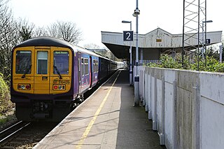
Nunhead railway station is in the Nunhead area of the London Borough of Southwark. It is 5 miles 77 chains (9.6 km) measured from London Victoria. The station is managed by Thameslink. It is in Travelcard Zone 2.

The South East London Green Chain, also known as the Green Chain Walk, is a linked system of open spaces between the River Thames and Crystal Palace Park in London, England. In 1977 four London boroughs and the Greater London Council created this Green Chain of 300 open spaces to protect them from building activity. The four London boroughs are Bexley, Bromley, Lewisham and Greenwich. More recently it has been extended to include sections in Southwark. Many parts of the system are also part of the Capital Ring route.

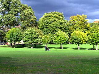
Dulwich Park is a 30.85-hectare (76.2-acre) public park in Dulwich in the London Borough of Southwark, south London, England. The park was created by the Metropolitan Board of Works from former farmland and meadows. While the initial design was by Charles Barry (junior), it was later refined by Lt Col JJ Sexby. It was opened in 1890 by Lord Rosebery. From 2004 to 2006, the park was restored to its original Victorian layout, following a grant from the Heritage Lottery Fund. The park is listed Grade II on the Register of Historic Parks and Gardens.

Green space in central London consists of five of the capital's eight Royal Parks, supplemented by a number of small garden squares scattered throughout the city centre. Open space in the rest of the region is dominated by the remaining three Royal Parks and many other parks and open spaces of a range of sizes, run mainly by the local London boroughs, although other owners include the National Trust and the City of London Corporation.
Peckham Rye is an open space and road in the London Borough of Southwark in London, England. The roughly triangular open space lies to the south of Peckham town centre. It is managed by Southwark Council and consists of two contiguous areas, with Peckham Rye Common to the north and Peckham Rye Park to the south. The road Peckham Rye forms the western and eastern perimeter of the open space.

Sydenham Hill forms part of a longer ridge and is an affluent locality in southeast London. It is also the name of a road which runs along the northeastern part of the ridge, demarcating the London Boroughs of Southwark, Bromley, and Lewisham. Its highest part is the apex of the Boroughs of Southwark and Lewisham and the 15th-highest peak in London, at 367 feet (112 m).

The A2216 is an A road in south London, England suburbia. It runs from the A215 in Denmark Hill to the A212 in Sydenham. Part of the road is an ancient thoroughfare, Lordship Lane. In Dulwich, the road runs via the A205 South Circular Road.
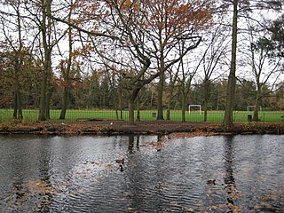
Belair Park is a park located in the West Dulwich part of the London Borough of Southwark, southeast London, England. The park grounds once belonged to Belair House, a country villa built in Adam style that is now a Grade II listed building. There are also two other Grade II listed structures within the park: the lodge and entrance gate, and an old stable building.

Sydenham Hill Wood is a ten-hectare wood on the northern slopes of the Norwood Ridge in the London Borough of Southwark. It is designated as a Local Nature Reserve and Site of Metropolitan Importance for Nature Conservation. With the adjacent Dulwich Wood, Sydenham Hill Wood is the largest extant tract of the ancient Great North Wood. The two woods are formed from coppices known as Lapsewood, Old Ambrook Hill Wood and Peckarmans Wood after the relocation of The Crystal Palace in 1854 and the creation of the high level line in 1865.

Tabard Gardens is a small park in Southwark, London. It is located on Tabard Street and gives its name to the surrounding Tabard Gardens Estate. The park was created as part of a slum clearance programme by the London County Council and opened in 1929. It is owned and managed by Southwark Council.

Brimmington Park is a small 1.79 hectares park in Peckham, London. It is located on Old Kent Road, Clifton Crescent and Culmore Road, London SE15 2RQ. It is also adjacent to the former Old Kent Road and Hatcham railway station, which closed temporarily in 1917 but which has never been re-opened.
Lewisham West and East Dulwich is a proposed constituency of the House of Commons in the UK Parliament. Further to the completion of the 2023 Periodic Review of Westminster constituencies, it will first be contested at the next general election.

