Morden Park

Last updated

Morden Park
Greater London UK location map 2.svg
Red pog.svg
Morden Park
Location within Greater London
OS grid reference TQ248676
London borough
Ceremonial county Greater London
Region
Country England
Sovereign state United Kingdom
Post town MORDEN
Postcode district SM4
Dialling code 020
Police Metropolitan
Fire London
Ambulance London
UK Parliament
London Assembly
List of places
UK
England
London
51°23′37″N0°12′19″W / 51.3936°N 0.2052°W / 51.3936; -0.2052

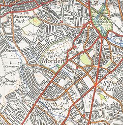
Morden Park is an area within the district of Morden in the London Borough of Merton, and includes the Park itself, an area of green space in an otherwise dense cluster of 1930s suburban housing.

Contents

The present park and sports fields between Hillcross Avenue, London Road/Epsom Road and Lower Morden Lane are owned and managed by the London Borough of Merton parks department and cover land that previously formed the grounds of Morden Park House, a small 18th-century country estate (not to be confused with Morden Hall Park, the National Trust property close to Morden town centre).

History

The estate originally comprised enclosed parkland, a small Georgian country house built at the top of the hill in the 1770s for merchant and distiller John Ewart with attached landscaped gardens and a farm called Morden Park Farm. By the mid-1780s the estate was in the possession of the Polhill family. [1] One member of the family, Edward Polhill, bequeathed £1,000 in 1826 to the parish church for the benefit of the Sunday school. [2]

Between the 1880s [3] and the 1910s the estate was occupied by banker John Wormald. [2]

The entrance to the Park, from London Road is now dominated by South Thames College, Merton Campus. This was built on the site of a Pig Farm which was destroyed by fire at some point in the late 1940s or early 1950s. The derelict sites remained in place for some years until the early 1960s when clearing began for the College. During this period many bones could be found amongst the rubble; these have been assumed by archaeologists to be those of pigs. Children from the Council Estate opposite the entrance at Hatfield Mead used this area as an adventure playground for many years. At this period a Gatehouse (occupied until its demolition in the 1960s) was prominent at the entry.

Bordering the park to the South West, next to The George Inn was the RG Jones Recording Studios where a number of Pop Groups in the 60's (including notably The Rolling Stones) had recording sessions.

Geography

At the bottom of the hill in the direction of Lower Morden runs a small brook.

A large circular mound in the park has been identified as a possible burial mound from the Iron Age, Roman or Saxon periods. Archaeological investigations were carried out in the 1950s although no conclusive proof as to its date or purpose were found. English Heritage believes that the earthwork was remodelled at some time into a belvedere, or viewing platform, with a spiral path to ascend it. Between 1960 and the mid-1990s a cycle speedway track sat alongside the mound, which was home to Morden Cycle Speedway Club. The track has since been demolished but it's still possible to find signs of the track's existence. A local Aero Modelling Club used the area South of the Mound on Sunday Mornings for flying practice.

Amenities

Morden Park House Morden Park House.JPG
Morden Park House

Morden Park House remains and, after many years of neglect and semi-dereliction, has recently been restored and is now the local register office and a venue for wedding ceremonies. [4]

Maps

A map of Morden Park from the 1920s Mordenmap 1920s.png
A map of Morden Park from the 1920s
A map of Morden Park from 1944 Morden map 1944.jpg
A map of Morden Park from 1944

Related Research Articles

<span class="mw-page-title-main">Mitcham</span> Human settlement in England

Mitcham is an area within the London Borough of Merton in Southwest London, England. It is centred 7.2 miles (11.6 km) southwest of Charing Cross. Originally a village in the county of Surrey, today it is mainly a residential suburb, and includes Mitcham Common. It has been a settlement throughout recorded history.

<span class="mw-page-title-main">Morden</span> Human settlement in England

Morden is a district and town in south London, England, within the London Borough of Merton, in the ceremonial county of Greater London. It adjoins Merton Park and Wimbledon to the north, Mitcham to the east, Sutton to the south and Worcester Park to the west, and is around 8 miles (13 km) south-southwest of Charing Cross. Prior to the creation of Greater London in 1965, for local government purposes, Morden was in the administrative and historic county of Surrey.

<span class="mw-page-title-main">Wimbledon, London</span> Suburb of London, England

Wimbledon is a district and town of Southwest London, England, 7.0 miles (11.3 km) southwest of the centre of London at Charing Cross; it is the main commercial centre of the London Borough of Merton. Wimbledon had a population of 68,187 in 2011 which includes the electoral wards of Abbey, Wimbledon Town and Dundonald, Hillside, Wandle, Village, Raynes Park and Wimbledon Park.

<span class="mw-page-title-main">London Borough of Merton</span> London borough in United Kingdom

The London Borough of Merton is a borough in Southwest London, England.

<span class="mw-page-title-main">Morden tube station</span> London Underground station

Morden is a London Underground station in Morden in the London Borough of Merton. The station is the southern terminus for the Northern line and is the most southerly station on the Underground network, despite being on the Northern Line. The next station towards north is South Wimbledon. The station is located on London Road (A24), and is in Travelcard Zone 4. Nearby are Morden Hall Park and Morden Park.

<span class="mw-page-title-main">Merton Park</span> Human settlement in England

Merton Park is a suburb in the London Borough of Merton. It is situated in Wimbledon. Bordering areas are Colliers Wood, Morden, South Wimbledon and Raynes Park. It is 7.25 miles (11.7 km) southwest of Charing Cross.It lies 2.8 miles east of Kingston upon Thames, 3 miles west of Mitcham and 4.5 miles north of Sutton.

<span class="mw-page-title-main">A24 road (England)</span> Major road in southern England

The A24 is a major road in England that runs for 53.2 miles (85.6 km) from Clapham in south-west London to Worthing on the English Channel in West Sussex via the suburbs of south-west London, as well as through the counties of Surrey and West Sussex.

<span class="mw-page-title-main">Raynes Park</span> Area of south London, in the borough of Merton

Raynes Park is a residential suburb, railway station and local centre near Wimbledon, London, and is within the London Borough of Merton. It is situated southwest of Wimbledon Common, to the northwest of Wimbledon Chase and to the east of New Malden, in South West London. It is 7.8 miles (12.5 km) southwest of Charing Cross. Towards the north and west, either side of the borough boundary with the Royal Borough of Kingston upon Thames are the areas of Copse Hill and Coombe with their large detached houses, golf courses and gated lands. Raynes Park had a population of 19,619 in 2011, which refers to the populations of the wards of Raynes Park and West Barnes.

<span class="mw-page-title-main">Motspur Park</span> Human settlement in England

Motspur Park, also known locally as West Barnes, is a residential suburb in south-west London, in the New Malden district. It straddles the boroughs of Kingston upon Thames and Merton.

<span class="mw-page-title-main">Lower Morden</span> Human settlement in England

Lower Morden is an area within the district of Morden in south west corner of the London Borough of Merton, to the west of Morden Park and south of Raynes Park.

<span class="mw-page-title-main">Sutton Common railway station</span> National Rail station in London, England

Sutton Common railway station is in Sutton Common in the London Borough of Sutton in South London. The station is served by Thameslink and Southern trains on the Sutton Loop Line. It is in Travelcard Zone 4. It has a single stepped entrance accessible from Sutton Common Road. It is the nearest rail station to the adjoining neighbourhood Benhilton via the footbridge at Angel Hill.

<span class="mw-page-title-main">South Merton railway station</span> National Rail station in London, England

South Merton railway station is located in Morden, the administrative centre of the London Borough of Merton in South London. The station is served by Thameslink trains on the Sutton Loop Line. It is in Travelcard Zone 4.

South Thames Colleges Group (STCG) is a large further education institution that operates four colleges in south-west London: South Thames College, Kingston College, Merton College, and Carshalton College. The four main campuses are in Wandsworth, Kingston upon Thames, Morden, and Carshalton.

<span class="mw-page-title-main">A217 road</span> Road in England

The A217 is a road in London and Surrey in England. It runs north–south. It runs from Kings Road in Fulham, London, crosses the Thames at Wandsworth Bridge, then passes through Wandsworth, Earlsfield, Summerstown, Tooting, Mitcham, Rosehill and Sutton Common in Sutton, then Cheam. Then, widened as a dual carriageway, comes Belmont, a suburban district built on a slope rising southward. On the North Downs in Surrey the road then skirts past Banstead and through its late 19th century offspring villages particularly Burgh Heath and Kingswood, Surrey. It then crosses the M25 motorway at Junction 8, then, returning to single carriageways, passes through the castle town of Reigate. It then cuts through the green buffer farmland of two rural villages and terminates at the road network at Gatwick Airport's northern perimeter.

<span class="mw-page-title-main">Merton, London (parish)</span>

Merton is an ancient parish historically in Surrey, but which has since 1965 been part of Greater London. It is bounded by Wimbledon to the north, Mitcham to the east, Morden, Cheam and Cuddington to the south and (New) Malden to the west. The 1871 Ordnance Survey map records its area as 1,764.7 acres (7.1 km2).

<span class="mw-page-title-main">Cannon Hill Common</span>

Cannon Hill Common is a public park in the London Borough of Merton. It is situated near Raynes Park and Morden. It is also the location of a Local Nature Reserve and the Paddock Allotments.

<span class="mw-page-title-main">Pollards Hill</span> Human settlement in England

Pollards Hill is a small residential district straddling the south London boroughs of Croydon and Merton between Mitcham, Norbury and Thornton Heath. The boundary of the two boroughs is a street named Recreation Way. No roads directly cross the Croydon/Merton divide, and streets were planned according to each borough, leading to differing architectural or building schemes. Pollards Hill lends its name to a ward of the London Borough of Merton.

<span class="mw-page-title-main">Wandle Trail</span> Trail in London

The Wandle Trail is a 12.5-mile (20 km) walking and cycling trail that follows the River Wandle from Croydon to Wandsworth in south-west London.

<span class="mw-page-title-main">Sutton Common</span>

Sutton Common is the name of former common land and a district and neighbourhood located in Sutton, London. The area is mostly located within the London Borough of Sutton, with some of the streets to the north and west of Sutton Common Park adjoining Lower Morden and Morden within the London Borough of Merton. Much of the area is taken up by the large Kimpton Park commercial and industrial estate, adjoining the A217. It is served by Sutton Common railway station. The area to the south and east of Oldfields Road uses an SM1 postcode and the area to the north and west uses SM3.

<span class="mw-page-title-main">Morden Park (park)</span>

Morden Park is a 50-hectare (120-acre) public park and Site of Borough Importance for Nature Conservation, Grade 1, in the district of Morden Park in the London Borough of Merton. Of this, 28 hectares is a Local Nature Reserve. It is owned and managed by Merton Council. It includes Morden Park House.

References

  1. Motco.com Archived 14 June 2006 at the Wayback Machine 15 Miles Round London (First edition), J Cary, 1786, Morden Archived 28 September 2006 at the Wayback Machine
  2. 1 2 British History Online
  3. 1881 Census
  4. "Morden Park House". London Borough of Merton. Retrieved 8 May 2020.