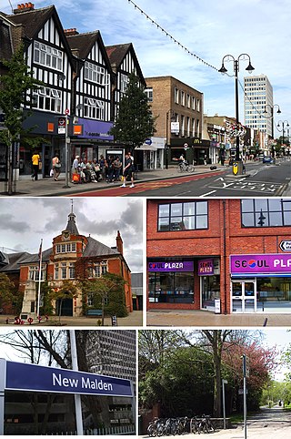
New Malden is an area in South West London, England. It is located within the Royal Borough of Kingston upon Thames and the London Borough of Merton, and is 9.4 miles (15.1 km) from Charing Cross. Neighbouring localities include Kingston, Norbiton, Raynes Park, Surbiton, Tolworth, Wimbledon and Worcester Park. Prior to the creation of Greater London in 1965, New Malden was in the administrative county of Surrey.

Kidbrooke is an area of South East London, England, in the Royal Borough of Greenwich 7+1⁄2 miles (12 km) south-east of Charing Cross and north west of Eltham.

Morden is a district and town in south London, England, within the London Borough of Merton, in the ceremonial county of Greater London. It adjoins Merton Park and Wimbledon to the north, Mitcham to the east, Sutton to the south and Worcester Park to the west, and is around 8 miles (13 km) south-southwest of Charing Cross. Prior to the creation of Greater London in 1965, for local government purposes, Morden was in the administrative and historic county of Surrey.

Totteridge is a residential area and former village in the London Borough of Barnet, England. It is a mixture of suburban development and open land situated 8 miles (13 km) north north-west of Charing Cross. It is part of the Whetstone postal district (N20).

Wimbledon is a district and town of Southwest London, England, 7.0 miles (11.3 km) southwest of the centre of London at Charing Cross; it is the main commercial centre of the London Borough of Merton. Wimbledon had a population of 68,187 in 2011 which includes the electoral wards of Abbey, Dundonald, Hillside, Trinity, Village, Raynes Park and Wimbledon Park.

The London Borough of Merton is a borough in Southwest London, England.

Upper Norwood is an area of south London, England, within the London Boroughs of Bromley, Croydon, Lambeth and Southwark. It is north of Croydon and the eastern part of it is better known as the Crystal Palace area. The SE19 London postcode covers the entirety of the district.

Merton Park is a suburb in the London Borough of Merton. It is situated between Colliers Wood, Morden, South Wimbledon and Raynes Park. It is 11 miles (11.7 km) southwest of Charing Cross. The area is part of the historic parish of Merton in West Surrey.

East Barnet is an area of north London within the London Borough of Barnet bordered by New Barnet, Cockfosters and Southgate. It is a largely residential suburb whose central area contains shops, public houses, restaurants and services, and the parish church of St Mary the Virgin. East Barnet is close to the M25 and the A1 and M1.

Raynes Park is a residential suburb, railway station and local centre near Wimbledon, London, and is within the London Borough of Merton. It is situated southwest of Wimbledon Common, to the northwest of Wimbledon Chase and to the east of New Malden, in South West London. It is 7.8 miles (12.5 km) southwest of Charing Cross. Towards the north and west, either side of the borough boundary with the Royal Borough of Kingston upon Thames are the areas of Copse Hill and Coombe with their large detached houses, golf courses and gated lands. Raynes Park had a population of 19,619 in 2011, which refers to the populations of the wards of Raynes Park and West Barnes.

Berrylands is a residential neighbourhood in Surbiton, London, originally forming part of the Municipal Borough of Surbiton, and since 1965 part of the Royal Borough of Kingston upon Thames. It is a suburban development situated 10.1 miles (16.3 km) south west of Charing Cross. Nearby places include Surbiton, New Malden, Old Malden, Tolworth and Chessington. Berrylands railway station is 24 minutes from London Waterloo by train.

Lower Morden is an area within the district of Morden in south west corner of the London Borough of Merton, to the west of Morden Park and south of Raynes Park.

Wimbledon is a constituency represented in the House of Commons of the UK Parliament. Since 2005, the seat has been represented by Stephen Hammond of the Conservatives.

Brookwood is a village in Surrey, England, about 3+1⁄2 miles (5.6 km) west of Woking, with a mixture of semi-rural, woodland-set and archetypal suburban residential homes. It lies on the western border of the Woking Borough, with a small part of the village in Guildford Borough. As part of the 2016 boundary review, Brookwood became part of the Heathlands ward which comprises Brookwood, Bridley, Hook Heath, Mayford, Sutton Green and Barnsbury and Wych Hill.

St Helier is a residential cottage estate in the London boroughs of Merton and Sutton. The portion of the estate north of Green Lane and Bishopsford Road is in Merton, the remainder is in Sutton.

Merton is an ancient parish historically in Surrey, but which has since 1965 been part of Greater London. It is bounded by Wimbledon to the north, Mitcham to the east, Morden, Cheam and Cuddington to the south and (New) Malden to the west. The 1871 Ordnance Survey map records its area as 1,764.7 acres (7.1 km2).

Cannon Hill Common is a public park in the London Borough of Merton. It is situated near Raynes Park and Morden. It is also the location of a Local Nature Reserve and the Paddock Allotments.

Pollards Hill is a small residential district straddling south London boroughs of Croydon and Merton between Mitcham, Norbury and Thornton Heath. The boundary of the two boroughs is a street named Recreation Way. No roads directly cross the Croydon and Merton divide, and streets were planned according to borough, leading to differing architectural or building schemes. It lends its name to a ward of the London Borough of Merton.
The Hale is an area and ward within the London Borough of Barnet. It is situated where the eastern part of Edgware meets the western part of Mill Hill and centres on the small retail centre at the junction of Deans Lane, Hale Lane and Selvage Lane. This centre constitutes Upper Hale, but is much better known locally as the 'Green Man' after the erstwhile pub of the same name that stood at the site from at least the early 18th century. A smaller area that was traditionally known as Lower Hale centres on the junction of Hale Lane, Farm Road and the nearby bridge over Deans Brook; this latter area is generally regarded as being within Edgware. The traditional area known as The Hale extends northwards from the 'Green Man' to the A41 and Apex Corner and the southern end is traditionally marked by the disused Edgware and Highgate railway line just south of West Way and Hale Drive; beyond lies Burnt Oak. Today's borough ward has slightly larger boundaries.
Copse Hill is a low-rise district of the London Borough of Merton to the south of Wimbledon Common, associated with Raynes Park its nearest railway station. It is on higher ground and has the largest green spaces associated with the Raynes Park/West Wimbledon area surrounding it. It was almost entirely privately developed; the nearest social housing areas are in Wimbledon, and Putney Vale.