Parkville, Summit County, Colorado

Last updated

Parkville
Hydraulic mining on Farncomb Hill above Parkville, Colorado.webp
Hydraulic mining on Farncomb Hill above Parkville, Colorado. This process ultimately led to the town being buried under waste rock.
Coordinates: 39°29′56″N105°57′00″W / 39.4989°N 105.9500°W / 39.4989; -105.9500 [lower-alpha 1]
CountryUnited States
State Colorado
County Summit County
Elevation
10,466 ft (3,190 m)
Population
  Total0

Parkville (also known as Park City) [1] is a ghost town located in, and the original county seat of, Summit County, Colorado, United States. Parkville was a gold mining camp that flourished from 1860 to 1866 near the confluence of the middle and south forks of the Swan River. [2]

Contents

History

Parkville was established around 1860 in Georgia Gulch near Swan River, with cabins by 1861. The population of the site soon rose to around 1,800. [3] When the new Territory of Colorado created its 17 original counties on November 1, 1861, Parkville was designated the Summit County seat. At its creation, Summit County covered roughly the entire northwest portion of the Colorado Territory. Parkville was the site of among the earliest Freemason lodges in Colorado, with Summit Lodge No.2 among the lodges established with the formation of the Grand Lodge of Colorado. The earliest minutes from the Summit County commissioners shows that they rented the Masonic hall for meetings and county and district court. [4]

The region's gold rush drove much of Parkville's 1861 growth, with its discoveries among the most valuable in Colorado history; up to $800 (equivalent to $26,056in 2022) of gold was mined daily. [3] This saw the production of territorial gold token mintage at Parkville during the summer of 1861. These tokens–valued at $2.50, $5, and $10–were coined by J.J. Conway & Co. out of gold dust. These tokens did not look like standard U.S. coinage and were of varying fineness and weight, thus losing the confidence of the townsfolk. [5]

Parkville, then the largest town in the region, was "the logical choice" to become the Summit County seat. [3] Parkville lost a 1861 vote to become the territorial capital by eleven votes; after the county seat was moved to Breckenridge due to Parkville's lack of facilities, Parkville would become a ghost town by 1882. [6] [7] [8] The former Parkville townsite is preserved as part of the Parkville Open Space, a 44-acre lot owned and operated by Summit County. [1] By 1911, later hydraulic mining had buried much of the former townsite in waste rock and the Masonic cemetery is among the few remaining visible relics. [6] [9]

See also

Notes

  1. The Geographic Names Information System incorrectly gives the Parkville coordinates as 39.4988727, −106.9500441.

Related Research Articles

<span class="mw-page-title-main">Summit County, Colorado</span> County in Colorado, United States

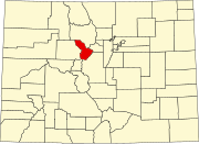
Summit County is a county located in the U.S. state of Colorado. As of the 2020 census, the population was 31,055. The county seat and largest town is Breckenridge.

<span class="mw-page-title-main">Gold Hill, Colorado</span> Census Designated Place in Colorado, United States

Gold Hill is an unincorporated community and a census-designated place (CDP) located in and governed by Boulder County, Colorado, United States. The CDP is a part of the Boulder, CO Metropolitan Statistical Area. The population of the Gold Hill CDP was 218 at the United States Census 2020. The Boulder post office serves the area.

<span class="mw-page-title-main">Breckenridge, Colorado</span> Town in Colorado, United States

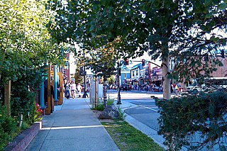
Breckenridge is the home rule municipality that is the county seat and the most populous municipality of Summit County, Colorado, United States. The town population was 5,078 at the 2020 United States Census. Breckenridge is the principal town of the Breckenridge, CO Micropolitan Statistical Area. The town also has many part-time residents, as many people have vacation homes in the area. The town is located at the base of the Tenmile Range.

<span class="mw-page-title-main">Gilman, Colorado</span> Town in Colorado, United States

Gilman is an abandoned mining town in southeastern Eagle County, Colorado, United States. The Gilman post office operated from November 3, 1886, until April 22, 1986. The U.S. Post Office at Minturn now serves Gilman postal addresses.

<span class="mw-page-title-main">Caribou, Colorado</span> Ghost town

Caribou is an extinct silver mining town located near Nederland in Boulder County, Colorado, United States. It was named after the Caribou silver mine nearby. The Caribou post office operated from January 31, 1871, until March 31, 1917. The Caribou Ranch recording studio was located several miles away, on the road from Nederland up to Caribou.

Arapahoe was one of the first settlements in what is now the U.S. state of Colorado. Nothing remains of the now deserted ghost town in Jefferson County, except a historical marker on the south side of 44th Avenue, between the towns of Golden and Wheat Ridge.

<span class="mw-page-title-main">Eureka, Colorado</span> Ghost town in San Juan County, Colorado, United States.

Eureka is an extinct mining town in San Juan County, Colorado, United States, along the Animas River, between Silverton and Animas Forks. The town derives its name from the Greek interjection Eureka! The Eureka post office operated from August 9, 1875, until April 30, 1942.

<span class="mw-page-title-main">Dyersville, Colorado</span>

Dyersville was a mining town — now a ghost town — in Summit County, Colorado, United States. It was named after Methodist minister John Lewis Dyer. Nothing remains of the town except the roofless walls of a couple of log cabins.

Saratoga County was a county of the extralegal United States Territory of Jefferson that existed from November 28, 1859, until February 28, 1861.

<span class="mw-page-title-main">Nevadaville, Colorado</span> American gold-mining town

Nevadaville was a gold-mining town in Gilpin County, Colorado, United States. It was also known in the 1860s and 1870s as Nevada City. The post office at Nevadaville was called the Bald Mountain post office, to avoid confusion with other Nevadas and Nevadavilles. The community is now largely a ghost town, although not completely deserted. The Nevadaville Masonic Temple that started in 1861 still holds regular meetings.

<span class="mw-page-title-main">Buckskin Joe, Park County, Colorado</span> Ghost town

Buckskin Joe is an extinct gold mining town located in Park County, Colorado, United States. The town was founded in 1860 as Laurette in what was then the Kansas Territory. The Territory of Colorado was created on February 28, 1861, and the Laurette post office opened on November 14, 1861. Laurette was elected the Park County seat on January 7, 1862. The post office name was changed to Buckskin on December 21, 1865, although the town was popularly known as Buckskin Joe. The county seat was moved to Fair Play in 1867, and the Buckskin post office closed on January 24, 1873.

<span class="mw-page-title-main">Mount Sniktau</span> Mountain in the state of Colorado

Mount Sniktau is a high mountain summit in the Front Range of the Rocky Mountains of North America. The 13,240-foot (4,036 m) thirteener is located in Arapaho National Forest, 1.6 miles (2.5 km) northeast of Loveland Pass in Clear Creek County, Colorado, United States.

<span class="mw-page-title-main">Grizzly Peak (Summit County, Colorado)</span> Mountain in Colorado, USA

Grizzly Peak is a high mountain summit in the Front Range of the Rocky Mountains of North America. Also known as Grizzly Peak D, the 13,433-foot (4,094 m) thirteener is located in Arapaho National Forest, 2.1 miles (3.4 km) southeast by east of Loveland Pass, Colorado, United States, on the Continental Divide between Clear Creek and Summit counties. Its proximate parent peak is Torreys Peak.

Adelaide is an extinct town located in Fremont County, Colorado, United States. The townsite is located at 38.5600°N 105.0908°W at an elevation of 6,949 feet (2,118 m). Previously known as Robinson, the former mining camp and railroad water is located along the Phantom Canyon Road. The Adelaide Bridge is located just north of the townsite.

<span class="mw-page-title-main">Kokomo, Colorado</span> Ghost town in Summit County, Colorado

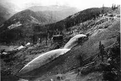
Kokomo is a silver- and gold-mining ghost town in Summit County, in the U.S. state of Colorado. Before being depopulated in the 1960s, Kokomo was at its height home to over 10,000 people.

<span class="mw-page-title-main">Preston, Colorado</span> Ghost town in Summit County, Colorado

Preston is a ghost town in Summit County, Colorado. It is located east of modern Breckenridge, between Jessie mine in Gold Run Gulch and the Jumbo mine.

<span class="mw-page-title-main">Red Mountain Town, Colorado</span> Ghost town in Ouray County, Colorado

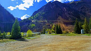
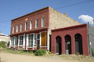
Red Mountain Town is a silver mining ghost town in Ouray County, Colorado, United States, south of Ouray along the "Million Dollar Highway".

References

  1. 1 2 "Featured Properties". Community Development Department, Summit County, Colorado . Retrieved March 1, 2023.
  2. "Parkville (historical): Summary Report". Geographic Names Information System . United States Geological Survey. October 13, 1978. Retrieved February 27, 2023.
  3. 1 2 3 Miller, Ruth (November 6, 2002). "Parkville becomes Colorado ghost town". Colorado Community Media. Retrieved March 1, 2023.
  4. "Summit Lodge No.2, A.F. & A.M." Longmont Masons. August 14, 2009. Retrieved February 27, 2023.
  5. "Colorado Gold!". Colorado Springs, CO: American Numismatic Association . Retrieved March 1, 2023 via Money.org.
  6. 1 2 Jessen, Kenneth (May 12, 2018). "Largest town in Summit County buried". Loveland Reporter-Herald. Loveland, CO . Retrieved March 7, 2023.
  7. Sinnwell, Michael J. (2006). "Parkville Colorado Townsite – Ghost town". Colorado Ghost Towns. Retrieved March 1, 2023.
  8. Dutta, Deepan (August 18, 2018). "Summit County mining history runs deep after prospectors first struck gold near Breckenridge in 1859". Summit Daily. Retrieved March 7, 2023.
  9. Ransome, Frederick Leslie (1911). Geology and Ore Deposits of the Breckenridge District, Colorado (PDF). Professional Paper. Vol. 75. Washington, D.C.: United States Geological Survey. p. 17. Retrieved March 7, 2023.