Copper Mountain, Colorado

Last updated

Copper Mountain, Colorado
Tucker Mountain at Copper Mountain Resort.jpg
Tucker Mountain at Copper Mountain Resort.
Summit County Colorado Incorporated and Unincorporated areas Copper Mountain Highlighted 0817150.svg
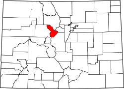
Location of the Copper Mountain CDP in Summit County, Colorado.
Usa edcp location map.svg
Red pog.svg
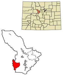
Copper Mountain
Location of the Copper Mountain CDP in the United States.
Coordinates: 39°28′37″N106°12′04″W / 39.47694°N 106.20111°W / 39.47694; -106.20111 (Copper Mountain CDP, Colorado) [1]
Country Flag of the United States.svg  United States
State Flag of Colorado.svg  Colorado
County Summit County
Government
[1]
  Type unincorporated community
Area
[2]
  Total32.058 sq mi (83.030 km2)
  Land32.058 sq mi (83.030 km2)
  Water0.000 sq mi (0.000 km2)
Elevation
[1]
11,362 ft (3,463 m)
Population
 (2020) [3]
  Total650
  Density20/sq mi (7.8/km2)
Time zone UTC-7 (MST)
  Summer (DST) UTC-6 (MDT)
ZIP Code [4]
Frisco 80443
Area code 970
GNIS feature 2583226 [1]

Copper Mountain is an unincorporated community and a census-designated place (CDP) located in and governed by Summit County, Colorado, United States. The CDP is a part of the Breckenridge, CO Micropolitan Statistical Area. The population of the Copper Mountain CDP was 650 at the United States Census 2020. [3] The Copper Mountain Consolidated Metropolitan District provides services. The Frisco post office (Zip Code 80443) serves the area. [4] The Copper Mountain CDP includes the Copper Mountain Ski Resort and Copper Mountain village.

Contents

History

Copper Mountain was originally named "Wheeler" for a local judge and developer, and it has also been known as "Wheeler Station" in the past. The naming question was settled by a decision from the Board on Geographic Names, which ruled in favor of "Copper Mountain" in 1977. [1]

Geography

Copper Mountain is located approximately 20 miles (32 km) north-northeast of Leadville in the White River National Forest.

The Copper Mountain CDP has an area of 20,517 acres (83.030 km2), all land. [2]

Demographics

The United States Census Bureau initially defined the Copper Mountain CDP for the United States Census 2010.

Copper Mountain CDP, Colorado
YearPop.±%
2010 385    
2020 650+68.8%
Source: United States Census Bureau

See also

Related Research Articles

<span class="mw-page-title-main">Allenspark, Colorado</span> Census Designated Place in Colorado, United States

Allenspark is an unincorporated town, a post office, and a census-designated place (CDP) located in and governed by Boulder County, Colorado, United States. The CDP is a part of the Boulder, CO Metropolitan Statistical Area. The Allenspark post office has the ZIP code 80510. At the United States Census 2020, the population of the Allenspark CDP was 568.

<span class="mw-page-title-main">Edwards, Colorado</span> Census Designated Place in Colorado, United States

Edwards is an unincorporated town, a post office, and a census-designated place (CDP) located in and governed by Eagle County, Colorado, United States. Edwards is the principal town of the Edwards, CO Micropolitan Statistical Area. The Edwards post office has the ZIP Code 81632. At the United States Census 2020, the population of the Edwards CDP was 11,246. The Edwards Metropolitan District provides services.

<span class="mw-page-title-main">El Jebel, Colorado</span> Census Designated Place in Colorado, United States

El Jebel is an unincorporated community and a census-designated place (CDP) located in and governed by Eagle County, Colorado, United States. The CDP is a part of the Edwards, CO Micropolitan Statistical Area. The population of the El Jebel CDP was 4,130 at the United States Census 2020. The Carbondale Post Office serves El Jebel postal addresses.

<span class="mw-page-title-main">Keystone, Colorado</span> Home rule municipality in Colorado, United States

Keystone is an unincorporated community and a census-designated place (CDP) located in and governed by Summit County, Colorado, United States. The CDP is a part of the Breckenridge, CO Micropolitan Statistical Area. The population of the Keystone CDP was 1,369 at the United States Census 2020. The Dillon post office (Zip Code 80435) serves Keystone postal addresses. The Keystone CDP includes the Keystone Resort and Keystone village.

<span class="mw-page-title-main">Woody Creek, Colorado</span> Census Designated Place in Colorado, United States

Woody Creek is an unincorporated town, a post office, and a census-designated place (CDP) located in and governed by Pitkin County, Colorado, United States. The Woody Creek post office has the ZIP Code 81656. At the United States Census 2020, the population of the Woody Creek CDP was 290. The Woody Creek Metropolitan District provides services. The CDP is a part of the Glenwood Springs, CO Micropolitan Statistical Area.

<span class="mw-page-title-main">Heeney, Colorado</span> Census Designated Place in Colorado, United States

Heeney is an unincorporated community and a census-designated place (CDP) located in and governed by Summit County, Colorado, United States. The CDP is a part of the Breckenridge, CO Micropolitan Statistical Area. The population of the Heeney CDP was 74 at the United States Census 2020. The Silverthorne post office (Zip Code 80498) serves Heeney postal addresses.

<span class="mw-page-title-main">Coaldale, Colorado</span> Census-designated place in Fremont County, Colorado, United States

Coaldale is a census-designated place (CDP) and post office located in and governed by Fremont County, Colorado, United States. The CDP is a part of the Cañon City, CO Micropolitan Statistical Area. The Coaldale post office has the ZIP Code 81222. At the United States Census 2020, the population of the Coaldale CDP was 343.

<span class="mw-page-title-main">Cotopaxi, Colorado</span> Census Designated Place in Colorado, United States

Cotopaxi is an unincorporated town, a post office, and a census-designated place (CDP) located in and governed by Fremont County, Colorado, United States. The CDP is a part of the Cañon City, CO Micropolitan Statistical Area. The Cotopaxi post office has the ZIP Code 81223. At the United States Census 2020, the population of the Cotopaxi CDP was 44.

<span class="mw-page-title-main">Howard, Colorado</span> Census-designated place in Fremont County, Colorado, United States

Howard is a census-designated place (CDP) and post office in and governed by Fremont County, Colorado, United States. The CDP is a part of the Cañon City, CO Micropolitan Statistical Area. The Howard post office has the ZIP Code 81233. At the United States Census 2020, the population of the Howard CDP was 852.

<span class="mw-page-title-main">Marvel, Colorado</span> Census-designated place in La Plata County, Colorado, United States

Marvel is a census-designated place (CDP) and post office on the Southern Ute Indian Reservation in southwestern La Plata County, Colorado, United States. The population was 68 at the 2020 census. The CDP is a part of the Durango, CO Micropolitan Statistical Area. The Marvel post office has the ZIP Code 81329.

<span class="mw-page-title-main">Orchard, Colorado</span> Unincorporated community in Colorado, United States

Orchard is an unincorporated town, a post office, and a census-designated place (CDP) located in and governed by Morgan County, Colorado, United States. The CDP is a part of the Fort Morgan, CO Micropolitan Statistical Area. The Orchard post office has the ZIP Code 80649. As of the 2020 census, the population of the Orchard CDP was 76.

<span class="mw-page-title-main">Redvale, Colorado</span> Census-designated place in Colorado, United States

Redvale is an unincorporated town, a post office, and a census-designated place (CDP) located in and governed by Montrose County, Colorado, United States. The CDP is a part of the Montrose, CO Micropolitan Statistical Area. The Redvale post office has the ZIP Code 81431. At the 2020 census, the population of the Redvale CDP was 172, down from 236 in 2010.

<span class="mw-page-title-main">Wolcott, Colorado</span> Census Designated Place in Colorado, United States

Wolcott is an unincorporated town, a post office, and a census-designated place (CDP) located in and governed by Eagle County, Colorado, United States. The CDP is a part of the Edwards, CO Micropolitan Statistical Area. The Wolcott post office has the ZIP Code 81655. At the United States Census 2020, the population of the Wolcott CDP was 20.

<span class="mw-page-title-main">Redstone, Colorado</span> Census Designated Place in Colorado, United States

Redstone is an unincorporated town and a census-designated place (CDP) located in and governed by Pitkin County, Colorado, United States. The CDP is a part of the Glenwood Springs, CO Micropolitan Statistical Area. The population of the Redstone CDP was 127 at the 2020 United States census. The Carbondale post office (Zip Code 81623) serves Redstone postal addresses.

<span class="mw-page-title-main">Bonanza Mountain Estates, Colorado</span> Census Designated Place in Colorado, United States

Bonanza Mountain Estates is an unincorporated community and a census-designated place (CDP) located in and governed by Boulder County, Colorado, United States. The CDP is a part of the Boulder, CO Metropolitan Statistical Area. The population of the Bonanza Mountain Estates CDP was 127 at the United States Census 2020. The Nederland post office serves the area.

<span class="mw-page-title-main">Mountain Meadows, Colorado</span> Census Designated Place in Colorado, United States

Mountain Meadows is an unincorporated community and a census-designated place (CDP) located in and governed by Boulder County, Colorado, United States. The CDP is a part of the Boulder, CO Metropolitan Statistical Area. The population of the Mountain Meadows CDP was 237 at the United States Census 2020. The Boulder post office serves the area.

<span class="mw-page-title-main">Fulford, Colorado</span> Census-designated place in Colorado, United States

Fulford is an extinct town and a census-designated place (CDP) located in Eagle County, Colorado, United States. The population of the Fulford CDP was 0 at the United States Census 2020. The CDP is a part of the Edwards, CO Micropolitan Statistical Area. The Fulford post office operated from February 5, 1892, until May 15, 1910. The Edwards post office now serves the area.

<span class="mw-page-title-main">Garfield, Colorado</span> Census Designated Place in Colorado, United States

Garfield is an unincorporated community and a census-designated place (CDP) located in and governed by Chaffee County, Colorado, United States. The population of the Garfield CDP was 27 at the United States Census 2020. The Salida post office serves the area.

<span class="mw-page-title-main">Morgan Heights, Colorado</span> Unincorporated community in Colorado, United States

Morgan Heights is an unincorporated community and a census-designated place (CDP) located in and governed by Morgan County, Colorado, United States. The CDP is a part of the Fort Morgan, CO Micropolitan Statistical Area. The population of the Morgan Heights CDP was 298 at the United States Census 2020. The Fort Morgan post office (Zip Code 80701) serves the area.

<span class="mw-page-title-main">Brook Forest, Colorado</span> Census Designated Place in Colorado, United States

Brook Forest is an unincorporated community and a census-designated place (CDP) located in and governed by Jefferson and Clear Creek counties, Colorado, United States. The population was 622 at the 2020 census. The CDP is a part of the Denver–Aurora–Lakewood, CO Metropolitan Statistical Area. The Evergreen Post Office serves the area.

References

  1. 1 2 3 4 5 U.S. Geological Survey Geographic Names Information System: Copper Mountain, Colorado
  2. 1 2 "State of Colorado Census Designated Places - BAS20 - Data as of January 1, 2020". United States Census Bureau . Retrieved December 27, 2020.
  3. 1 2 United States Census Bureau. "Copper Mountain CDP, Colorado" . Retrieved April 13, 2023.
  4. 1 2 "Zip Code 80443 Map and Profile". zipdatamaps.com. 2020. Retrieved December 27, 2020.