
Presidio County is a county located in the U.S. state of Texas. As of the 2020 census, its population was 6,131. Its county seat is Marfa. The county was created in 1850 and later organized in 1875. Presidio County is in the Trans-Pecos region of West Texas and is named for the border settlement of Presidio del Norte. It is on the Rio Grande, which forms the Mexican border.

San Elizario is a city in El Paso County, Texas, United States. Its population was 10,116 at the 2020 census. It is part of the El Paso metropolitan statistical area. It lies on the Rio Grande, which forms the border between the United States and Mexico. The city of Socorro adjoins it on the west and the town of Clint lies to the north.

Goliad is a city and the county seat of Goliad County, Texas, United States. It is known for the 1836 Goliad massacre during the Texas Revolution. It had a population of 1,620 at the 2020 census. It is part of the Victoria, Texas, Metropolitan Statistical Area.
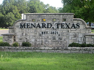
Menard is a city in and the county seat of Menard County, Texas, United States. Its population was 1,348 at the 2020 census.

Redford is a census-designated place (CDP) in Presidio County, Texas, United States. The population was 43 at the 2020 census.
El Porvenir or Porvenir may refer to:
Wallisville is an unincorporated town in northern Chambers County, Texas, United States. According to the Handbook of Texas, the community had a population of 460 in 2000. It is located within the Greater Houston metropolitan area.
Needle Peak is located in Presidio County, in southwest Texas, United States. Its summit, at an elevation of 4,608 feet (1,405 m) above sea level, rises 328 ft (100 m) over the Lower Shutup, a canyon that runs along its eastern edge. Needle Peak is a Tertiary intrusion and stands within the Solitario, a circular domal uplift with a nine-mile diameter and a prominent limestone rim. The area is desert mountain terrain of basalt deposits. The vegetation consists primarily of sparse grasses, cacti, desert shrubs, and scrub brush. Needle Peak was named for its configuration.

Arroyo Corte Madera del Presidio is a 4.1-mile-long (6.6 km) year-round stream in southern Marin County, California, United States. This watercourse is also known as Corte Madera Creek, although the actual stream of that name flows into San Francisco Bay further north at Point San Quentin. This watercourse has a catchment basin of about 8 square miles (21 km2) and drains the south-eastern slopes of Mount Tamalpais and much of the area in and around the town of Mill Valley; this stream discharges to Richardson Bay.
Chinati is an unincorporated community in Presidio County, Texas, United States.
Ruidosa is an unincorporated desert village in Presidio County, Texas, United States. Although called a ghost town by some sources, there were 43 inhabitants as of 2000 and a small store.

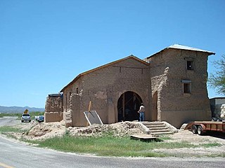
The Presidio Nuestra Señora de Loreto de la Bahía, known more commonly as Presidio La Bahía, or simply La Bahía, is a fort constructed by the Spanish Army. It became the center of a community that developed as the modern-day city of Goliad, Texas, United States. The current location dates to 1747.

In the early morning hours of August 16, 1931, a powerful earthquake occurred in West Texas with a maximum Mercalli intensity of VIII (Severe). Estimates of its magnitude range between 5.8 and 6.4 mb, making it the most powerful earthquake ever recorded in Texas history. Its epicenter was near the town of Valentine, Texas; there, the earthquake caused damage to many homes and buildings. The earthquake may have been caused by movement along oblique-slip faulting in West Texas, the most seismically active region in the state. Shaking from the earthquake was perceptible within a 400 mi (640 km) radius of the epicenter, affecting four U.S. states and northern Mexico. Several foreshocks and aftershocks accompanied the primary temblor, with the aftershocks continuing until at least November 3, 1931. The main earthquake caused no fatalities, though several people sustained minor injuries; the damage in Valentine amounted to $50,000–$75,000.

The Brite Ranch raid was an incident that occurred on Christmas Day 1917, in which Mexican raiders crossed the Rio Grande River border and attacked a ranch in Presidio County, Texas. At the time the raiders were thought to be Villistas, as they had been responsible for several other previous incursions into American territory, though other accounts say that some Carrancistas were involved as well. During the raid the Mexicans murdered three people, robbed a general store and rode back to Chihuahua under pursuit by a motorized posse and troops of the United States Army 8th Cavalry. The Americans fought a running battle with the Mexicans on December 26 that resulted in the deaths of several raiders and the recovery of some stolen property. Soon after, an expedition to find more of the raiders led to another more violent episode when, on January 27, 1918, a force of Texas Rangers accompanied by US Cavalry, executed 15 Mexican men in what became known as the Porvenir Massacre.
Adobes was a small farming community and now a ghost town, located on the Rio Grande and Farm to Market Road 170 in Presidio County, Texas, United States. It was founded in the 1870s. Cotton began to be grown in the area in 1914, and by 1930 the community had 750 acres (300 ha) of irrigated land.
Fort Holland is a ghost town and former military installment in Presidio County, Texas, United States. It is located west of the city of Valentine.

The Porvenir massacre was an incident on January 28, 1918, outside the village of Porvenir, in Presidio County, Texas, in which Texas Rangers and local ranchers, with the support of US Cavalry, killed 15 unarmed Mexican American boys and men. The Texas Rangers Company B had been sent to the area to stop banditry after the Brite Ranch raid. Despite having no evidence that the Porvenir villagers had been involved in recent thefts or the killings of ranchers, the Rangers separated 15 men and boys from the rest of the village and shot them on a nearby hill.

El Porvenir is an unincorporated community in San Miguel County, New Mexico, United States.
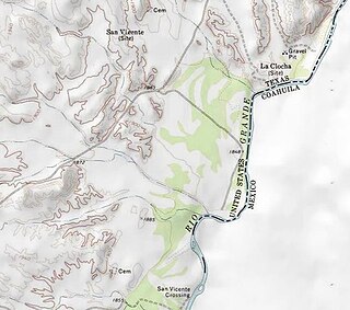
San Vicente was a village located in Brewster County, Texas, United States, within the protruding big bend of the Rio Grande. The village was geographically 1.5 miles (2.4 km) north of the San Vicente Crossing in present-day Big Bend National Park. The uninhabited site provides a panoramic view of the Chisos Mountains and the Sierra San Vicente migrating into Northern Mexico.

Pilares was a village located in northwest Presidio County, Texas, United States, on the southern boundary of the Sierra Vieja near the Rio Grande. The river village was 1.25 miles (2.01 km) south of the confluence of Quinn Creek and the Rio Grande while bearing 1.5 miles (2.4 km) north of Porvenir, Texas. The uninhabited site is in the Trans-Pecos region of West Texas with a southern panorama of the Chihuahuan Desert and northern Mexico.


