Pudumadam

Last updated

Pudumadam
Village
PdmMidjamath.jpg
Middle Street Masjid
India Tamil Nadu location map.svg
Red pog.svg
Pudumadam
Location in Tamil Nadu, India
India location map.svg
Red pog.svg
Pudumadam
Pudumadam (India)
Coordinates: 9°16′37″N78°59′38″E / 9.27702°N 78.993845°E / 9.27702; 78.993845
Sub-district Ramanathapuram
District Ramanathapuram
State Tamil Nadu
CountryFlag of India.svg  India
Named for Fishing and small business
Government
  TypePanchayat Board
  BodyPanchayat President (2013-May 2018)
  Rank10
Population
 (2017)
  Total8,760 [1]
  Rank7th (Ramanathapuram district)
Demonym Madathan
Languages
  Official Tamil
Time zone UTC+5:30 (IST)
PIN
623524
Telephone code04567-263
Vehicle registration TN 65
Nearest city
  • Ramanathapuram
  • Rameshwaram
Literacy79.3%
Lok Sabha constituency Ramanathapuram
Vidhan Sabha constituency Ramanathapuram
Climate Tropical savanna (Köppen: Aw) [2]
Website www.pudumadam.net

Pudumadam is a village located in the Ramanathapuram district of the Indian state of Tamil Nadu. [3] Situated near the old National Highway 49, which connects Kochi and Dhanushkodi, Pudumadam serves as a vital gateway to the picturesque Pamban Island. The village is approximately 25 kilometers away from the city of Ramanathapuram and 37 kilometers away from the renowned pilgrimage site of Rameswaram. The nearest train station is Uchippuli, located just 4 kilometers away from Pudumadam. [4] [5]

Contents

History

Pudumadam, formerly known as Maṟavar māṉāṅkuṭi, was a region under the rule of King Sethupathi, who governed Ramanathapuram. During King Sethupathi's reign, Raṅkācāri from the northern region, constructed a monastery known as "Madam in Tamil" in the area, which came to be called Pudumadam, meaning "New Monastery" in Tamil. Subsequently, the remaining portion of the region was separated and formed a distinct village known as Māṉāṅkuṭi.

The early population of Pudumadam comprised families from the ruling family and a few Muslim communities. As time passed, the village experienced significant migration, with people arriving from various areas, including Teṉputuvai, as recorded in historical literature.

It is worth noting that in the past, the western region where people resided was referred to as Karuvelanakad, named after the dense Mesquite Tree jungle, that characterized the area. This region extended towards the village of Periapattinam. Additionally, historical records indicate the presence of a limestone pit in the vicinity during that era.

Geography

Pudumadam village is situated in the Ramanathapuram taluka of the Ramanathapuram district in Tamil Nadu, India. It is located approximately 26 kilometers away from the district and sub-district headquarters of Ramanathapuram. The village spans an area of 783.05 hectares and falls under the jurisdiction of the Pudumadam Gram Panchayat. The nearest town for major economic activities is Ramanathapuram.

Pudumadam is located along the seashore and is known for its proximity to the Mannar Gulf, which is a sea located between Sri Lanka and India. The village is characterized by abundant coconut trees and palmyra palm. The groundwater in Pudumadam is of good quality and can be consumed without any additional treatment. The village experiences a tropical climate throughout the year.

The police jurisdiction for Pudumadam is Uchipuli, a nearby town.

Demographics

As per the Census of 2011, Pudumadam has a total population of 8,760 people, consisting of 4,454 males and 4,306 females. The village has a literacy rate of 79.32%, with 83.18% of males and 75.31% of females being literate. There are approximately 1,834 households in Pudumadam.

Here are the population details:

Total Population: 8,760 Male Population: 4,454 Female Population: 4,306 Literacy Rate: 79.32% Male Literacy Rate: 83.18% Female Literacy Rate: 75.31% Number of Houses: 1,834

Economy

Due to its coastal location on the Gulf of Mannar, fishing has traditionally been the primary occupation of the people of Pudumadam. Many residents rely on fishing as their main source of income. [6] [7] Additionally, a significant number of individuals from Pudumadam are employed in the Gulf countries.

The construction industry is a major source of employment for the majority of Christians in the village. They actively participate in construction projects both locally and in other regions.

In the past, some Hindus in Pudumadam were involved in the cultivation of betel-nut. However, this industry has experienced a decline in recent times.

Present-day Muslims in the village are engaged in various business activities, both locally and in different parts of India. A significant portion of the Muslim population is involved in the shoe business. Furthermore, there are individuals who are in the process of sending people abroad for employment opportunities.

Infrastructure

Transportation: The village is well-connected to nearby towns and cities through roadways. Public and private bus services are available within the village, providing transportation options for the residents. Additionally, there is a railway station located within a distance of 4 kilometers from Pudumadam, ensuring easy access to rail transportation.

Public Services: Pudumadam has basic public services such as electricity, water supply, and sanitation facilities. Efforts are made to ensure that the village has a reliable and consistent supply of electricity, clean water, and proper sanitation infrastructure.

Education: The village has educational facilities to cater to the needs of its residents. This includes primary and secondary schools that provide education to the children of Pudumadam. Additionally, efforts may have been made to promote literacy and provide access to higher education within or in nearby towns.

Healthcare: Access to healthcare services is crucial for the well-being of the residents. Pudumadam may have healthcare facilities such as primary health centers to provide basic medical services. In case of more serious medical issues, residents may need to visit nearby towns or cities with better-equipped hospitals and healthcare facilities.

Communication: Telecommunication infrastructure, including mobile network coverage and internet connectivity, is essential for communication purposes. Pudumadam may have access to telecommunication services to facilitate communication within the village and with the outside world.

Community Spaces: The village may have community spaces such as parks, playgrounds, or community centers where residents can engage in recreational activities or social gatherings.

Education

Pudumadam Higher Secondary School (previously Pudumadam High School) is located in Pudumadam, and serves the general area. [8]

Culture and Heritage

Religious census
ReligionPercent(%)
Muslim
95%
Christian
3%
Hindu
2%
Sikh
0%
Jain
0%
Other
0%

Pudumadam is a culturally diverse village, with a predominant Muslim population comprising approximately 95% of the total population. The remaining population consists of approximately 3% Christians and 2% Hindus. This diverse mix of religious communities contributes to the rich cultural fabric of the village.

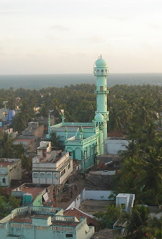
The Muslim community in Pudumadam plays a significant role in shaping the local culture and traditions. The village is home to four mosques located at South Street, North Street, Middle Street, and Tamil Nadu Thawheed. These mosques serve as important religious and community centers for the Muslim residents. The construction and maintenance of these mosques are largely community-funded initiatives.

In addition to the Muslim places of worship, Pudumadam also hosts several Hindu temples and one Christian church. These religious sites are important landmarks in the village and contribute to the religious and cultural practices of the Hindu and Christian communities respectively.

The cultural celebrations and festivals in Pudumadam reflect the diversity of its population. Major Islamic festivals such as Eid-ul-Fitr and Eid-ul-Adha are celebrated with great enthusiasm by the Muslim community. The Hindu festivals like Diwali, Pongal, and Navaratri are also observed with fervor. Additionally, the Christian community celebrates festivals such as Christmas and Easter.

The village of Pudumadam takes pride in preserving its cultural heritage and traditions. The harmonious coexistence of different religious communities and the celebration of their respective customs and festivals contribute to the vibrant cultural tapestry of the village.

Centre for Marine and Coastal Studies

Pudumadam is home to Madurai Kamaraj University‘s Centre for Marine and Coastal Studies. The facility is partially funded by the Indian government's Ministry of Earth Sciences, and assists in the development of seawater quality criteria for the Gulf of Mannar. The Institute for Integrated Coastal Area and Marine Management, an agency of the Ministry of Earth Sciences, has sought a report from the Centre regarding their findings. [9]

Utilities

The main water supply of the village is taken from a rainwater canal called Tharavai. Community movements have organized to protect this resource, by building a small dam and planting trees.[ citation needed ]

Related Research Articles

<span class="mw-page-title-main">Rameswaram</span> Pilgrimage centre and a town in Tamilnadu, India

Rameswaram is a municipality in the Ramanathapuram district of the Indian state of Tamil Nadu. It is on Pamban Island separated from mainland India by the Pamban channel and is about 40 kilometres from Mannar Island, Sri Lanka. It is in the Gulf of Mannar, at the tip of the Indian peninsula. Pamban Island, also known as Rameswaram Island, is connected to mainland India by the Pamban Bridge. Rameswaram is the terminus of the railway line from Chennai and Madurai. Together with Varanasi, it is considered to be one of the holiest places in India to Hindus and is part of the Char Dham pilgrimage.

<span class="mw-page-title-main">Thoothukudi</span> City in Tamil Nadu, India

Thoothukudi is a port city, a municipal corporation, and an industrial city in Thoothukudi district in the Indian state of Tamil Nadu. The city lies on the Coromandel Coast of the Bay of Bengal. Thoothukudi is the capital and headquarters of Thoothukudi district. It is located about 590 kilometres southwest of Chennai, 190 kilometres northeast of Thiruvananthapuram, and 580 kilometres southeast of Bengaluru. According to the Confederation of Indian Industry, Thoothukudi has the second highest Human Development Index in Tamil Nadu, next to Chennai. Thoothukudi City serves as the headquarters of Tamilnad Mercantile Bank Limited, one of the leading private sector banks in India. Major educational establishments in the city include the Government Thoothukudi Medical College, Fisheries College and Research Institute, Tamil Nadu Maritime Academy, V.O. Chidambaram College, Kamaraj College, Anna University, and Government Polytechnic College. The V.O. Chidambaranar Port Authority is one of the major ports in India. Thoothukudi is an emerging energy and industrial hub of South India.

Kayalpattinam is a Municipality in Thoothukudi district in the Indian state of Tamil Nadu. As of 2011, the town had a population of 40,588.

Ramanathapuram, also known as Ramnad, is a city and a municipality in Ramanathapuram district in the Indian state of Tamil Nadu. It is the administrative headquarters of Ramanathapuram district and the second largest town in Ramanathapuram district. Soon the Ramanathapuram Civic body to be upgraded as Municipal Corporation, after merging with nearby panchayats.

<span class="mw-page-title-main">Rajapalayam</span> Town in Tamil Nadu, India

Rajapalayam is a town in the Indian state of Tamil Nadu. It is the largest municipality in the Virudhunagar district. Rajapalayam is located on the Madurai to Quilon National Highway at a distance of 562 km south of the state capital Chennai. The economy is primarily industrial with several mills for spinning and weaving. The town is known for its mango and the Rajapalayam breed of dogs.

Kilakarai is a municipality in Ramanathapuram district in the Indian state of Tamil Nadu. As of 2011, the town had a population of 38,355. Kilakarai is one of the Taluka in Ramanathapuram District.

<span class="mw-page-title-main">Kanyakumari district</span> District of Tamil Nadu in India

Kanyakumari district is one of the 38 districts of Tamil Nadu state and the southernmost district in mainland India. It stands second in terms of population density among the districts of Tamil Nadu. It is also the richest district in Tamil Nadu in terms of per capita income, and also tops the state in Human Development Index (HDI), literacy, and education. The district's headquarters is Nagercoil.

<span class="mw-page-title-main">Melur</span> Municipality in Tamil Nadu, India

Melur is the Northern entrance of Madurai district. It is the town and municipality in the Madurai North in the Indian state of Tamil Nadu. Melur Old Name is Called Naduvi Nadu. The name Melur name comes from "Mela Nadu". Melur is called Thaigramam. It is the biggest taluk within the Madurai District. As of 2011, the town had a population of 40,017. Melur is an agricultural land in Madurai and the climate around the area is tropical.

Paramakudi or Paramagudi is the largest town in the district of Ramanathapuram in Tamil Nadu, with a population of over 95,579. It has been the taluk headquarters since 1918, since the formation of Ramanathapuram District.

<span class="mw-page-title-main">Ramanathapuram district</span> District of Tamil Nadu in India

Ramanathapuram District, also known as Ramnad District, is one of the 38 districts an administrative districts of Tamil Nadu state in southern India. The old Ramanathapuram District consists of Present day Virudhunagar and Sivagangai districts, it touches the Western ghats and bordered with the state of Kerala and east by Bay of Bengal. It was the largest district on that time. The town of Ramanathapuram is the district headquarters. Ramanthapuram District has an area of 4,123 km2. It is bounded on the north by Sivaganga District, on the northeast by Pudukkottai District, on the east by the Palk Strait, on the south by the Gulf of Mannar, on the west by Thoothukudi District, and on the northwest by Virudhunagar District. The district contains the Pamban Bridge, an east–west chain of low islands and shallow reefs that extend between India and the island nation of Sri Lanka, and separate the Palk Strait from the Gulf of Mannar. The Palk Strait is navigable only by shallow-draft vessels. As of 2011, Ramanathapuram district had a population of 1,353,445 with a sex-ratio of 983 females for every 1,000 males. The district is home to the pilgrimage center of Rameswaram.

Devadanapatti is a panchayat town in Periyakulam Taluk, a part of the Theni district in the Madurai Region in the state of Tamil Nadu, India. It is located at the bottom of the Kodaikanal Hills.

<span class="mw-page-title-main">Pamban Island</span> Island in the Indian Ocean between India and Sri Lanka

Pamban Island, also known as Rameswaram Island, is an island located between peninsular India and Sri Lanka, on the Adam's Bridge archipelago. The second largest island in the latter, Pamban Island belongs to India and forms the Rameswaram taluk of the Ramanathapuram district of the state of Tamil Nadu. It is the largest island in Tamil Nadu by area. The principal town in the island is the pilgrimage centre of Rameswaram.

<span class="mw-page-title-main">Adi Jagannatha Perumal Temple</span> Hindu temple in Ramanathapuram

The Adi Jagannatha Temple is a South Indian Hindu temple in Thiruppullani, a village in the outskirts of Ramanathapuram in the South Indian state of Tamil Nadu, is dedicated to the Hindu god Vishnu. It is believed that Rama used grass ('pul' in Tamil as a pillow to sleep and hence the village attained the name Thiruppullani. Constructed in the Cholan style of architecture, the temple is glorified in the Naalayira Divya Prabandham, the early medieval Tamil canon of the Alvar saints from the 6th–9th centuries CE. It is one of the 108 Divya Desam dedicated to Vishnu, who is worshipped as Adi Jagannatha and his consort Lakshmi as Padmasini.

<span class="mw-page-title-main">Mannar District</span> Administrative District in Northern, Sri Lanka

Mannar District is one of the 25 districts of Sri Lanka, the second level administrative division of the country. The district is administered by a District Secretariat headed by a District Secretary appointed by the central government of Sri Lanka. The capital of the district is Mannar, which is located on Mannar Island.

Periyapattinam is a large village located in the eastern part of Ramanathapuram district, Tamil Nadu, India. The inhabitants of this village are primarily Tamil Muslim.

Devipattinam is a coastal village of Ramanathapuram district, Tamil Nadu, India.

Appanur is a village in the Kadaladi Taluk of Ramanathapuram District in Tamil Nadu, India. It is located between Mudukulathur and Sayalgudi, on the State Highway 29 (SH29).

Alagankulam is a village situated on the east coast in the Ramanathapuram taluk and district in India. The village is situated on the banks of the Vaigai River and is about 3 kilometres (1.9 mi) away from the seashore. The village is located 18 kilometres (11 mi) east of Ramanathapuram. The village had a population of 15,473 at the 2011 census.

Alathambadi is a large village located in Thiruthuraipoondi of Thiruvarur district in the Indian state of Tamil Nadu.

Pirappan Valasai is a village in Mandapam block in Ramanathapuram District of Tamil Nadu, India.

References

  1. Census censusindia.gov.in [ dead link ]
  2. Peel, M. C.; Finlayson, B. L.; McMahon, T. A. (2007). "Updated world map of the Köppen-Geiger climate classification" (PDF). Hydrology and Earth System Sciences. 11 (5): 1633–1644. doi: 10.5194/hess-11-1633-2007 .
  3. NREGA report [ permanent dead link ]
  4. Ramanathapuram map pngrb.gov.in
  5. Tamil Nadu map censusindia.gov.in [ dead link ]
  6. Ancient Sri Lanka and Tamil Nadu: Maritime Trade linguist.univ-paris-diderot.fr
  7. Verma, Vikas Kumar (2006). "Maritime Trade Between Early Historic Tamil Nadu and Sri Lanka". Proceedings of the Indian History Congress. 67: 1006–1014. JSTOR   44148017.
  8. "Gt. HSS, Pudumadam High School, Ramanathapuram - Reviews, Fees, Admissions and Address 2021".
  9. "MKU-School of Energy, Environment and Natural Resources".