
The Isle of Wight is an island, English county and unitary authority in the English Channel, 2 to 5 miles off the coast of Hampshire, across the Solent. It is the largest and second-most populous island in England. Referred to as "The Island" by residents, the Isle of Wight has resorts that have been popular holiday destinations since Victorian times. It is known for its mild climate, coastal scenery, and verdant landscape of fields, downland, and chines. The island is historically part of Hampshire. The island is designated a UNESCO Biosphere Reserve. With a land area of 380 km2 (150 sq mi), it is about half the size of Singapore.
Sandown is a seaside resort and civil parish on the south-east coast of the Isle of Wight, England. The neighbouring resort of Shanklin and the settlement of Lake are sited just to the south of the town. Sandown has a population of 11,654 according to the 2021 Census, and the three Sandown Bay settlements form a built-up area of more than 20,000 inhabitants. Sandown is the Bay's northernmost town, with its easily accessible, sandy beaches running continuously from the cliffs below Battery Gardens in the south to Yaverland in the north.

Shanklin is a seaside resort town and civil parish on the Isle of Wight, England, located on Sandown Bay. Shanklin is the southernmost of three settlements which occupy the bay, and is close to Lake and Sandown. The sandy beach, its Old Village and a wooded ravine, Shanklin Chine, are its main attractions. The esplanade along the beach is occupied by hotels and restaurants for the most part, and is one of the most tourist-oriented parts of the town. The other is the Old Village, at the top of Shanklin Chine. Together with Lake and Sandown to the north, Shanklin forms a built up area of around 25,000 inhabitants, Shanklin alone contributing around 7,200 of this.

The ancient 'Kynges Towne' of Brading is the main town of the civil parish of the same name. The ecclesiastical parish of Brading used to cover about a tenth of the Isle of Wight. The civil parish now includes the town itself and Adgestone, Morton, Nunwell and other outlying areas between Ryde, St Helens, Bembridge, Sandown and Arreton. Alverstone was transferred to the Newchurch parish some thirty years ago.

Culver Down is a chalk down to the north of Sandown, Isle of Wight. It is believed that its name derives from "Culfre", which is Old English for dove.

Alverstone Mead Local Nature Reserve is a lowland freshwater wetland nature reserve close to Sandown, Isle of Wight. it is a part of the Alverstone Marshes Site of Special Scientific Interest.

Borthwood Copse, near Sandown, Isle of Wight, England is a piece of woodland owned by the National Trust and is one of the numerous copses which make up part of the medieval forest which covered most of the eastern end of the Island. Borthwood Copse sits on the outskirts of Newchurch, and is close to the neighbouring hamlet of Apse Heath and the villages of Queen's Bower and Alverstone. Borthwood Copse was originally a royal hunting ground. It was bequeathed to the National Trust in 1926 by Frank Morey. He had purchased it a few years earlier to preserve it for wildlife. Subsequent additions have been added to the land and it now covers a total of 60 acres (240,000 m2).

Knighton is a largely deserted hamlet near Newchurch on the Isle of Wight, about 2 miles NW of Sandown. The name should be pronounced as Kay-nighton to avoid confusion with the larger village of Niton, near Ventnor.
Newchurch is a village and civil parish on the Isle of Wight. It is located between Sandown and Newport in the southeast of the island.

Apse Heath is a hamlet on the Isle of Wight, UK. Apse Heath is centered on the intersection of Newport Road and Alverstone Road. At the 2011 Census the Post Office said the population of the hamlet was included in the civil parish of Newchurch, Isle of Wight. It is northeast of Whiteley Bank and south of Winford. Apse Heath is bordered by the leafy villages of Alverstone and Queen's Bower, and is surrounded by areas of woodland and agricultural land. It also sits roughly 2 miles east of the village of Newchurch, and 1 mile west of Lake.

Luccombe is a hamlet a short distance south of Shanklin, on the south coast of the Isle of Wight, England.
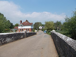
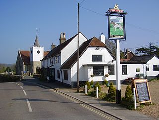
Alverstone is a village 2 miles from the east coast of the Isle of Wight, near Sandown. The name Alverstone is most likely of Saxon origin meaning "Alfred's Farm". Up until 1960, boating took place on the river and tea-gardens were very popular with local people, who came by train on excursions.
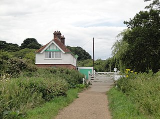
Alverstone railway station was an intermediate station situated on the edge of Alverstone village on the Isle of Wight, off the south coast of England.

Alverstone Garden Village is a housing estate built between the 1930s and the 1970s; entirely contained within Youngwoods Copse, and thus almost invisible from the older hamlet of Alverstone. At the 2011 Census the Post Office indicated that the population was included in the civil parish of Newchurch, Isle of Wight.

Eaglehead and Bloodstone Copses is a 10.3-hectare (25-acre) Site of Special Scientific Interest which is south of Ashey on the Isle of Wight. The site was notified in 1987 for its biological value.

PS Ryde is a paddle steamer that was commissioned and run by Southern Railway as a passenger ferry between mainland England and the Isle of Wight from 1937 to 1969, with an interlude during the Second World War where she served as a minesweeper and then an anti-aircraft ship, seeing action at D-Day. After many years abandoned on moorings at Island Harbour Marina on the River Medina, she was purchased by the PS Ryde Trust in late 2018, with the intention of raising money for her restoration. That project was abandoned in January 2019.

The Isle of Wight Coastal Path is a circular long-distance footpath of 70 miles (113 km) around the Isle of Wight, UK. It follows public footpaths and minor lanes, with some sections along roads.

Briddleford Copses is a 167.2-hectare (413-acre) Site of Special Scientific Interest (SSSI) and Special Area of Conservation (SAC) which is south of Wootton Bridge on the Isle of Wight in Britain. The site was designated an SAC in 1995 in recognition of the internationally important breeding population of Bechstein's bat that are resident there. The majority of the copses form part of the Briddlesford Nature Reserve, owned and managed by the People's Trust for Endangered Species (PTES), a charitable organisation.
Priory School is a co-educational independent school in Whippingham, Isle of Wight.
