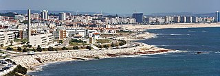
Figueira da Foz, also known as Figueira for short, is a city and a municipality in the Coimbra District, in Portugal. Practically at the midpoint of the Iberian Peninsula's Atlantic coast, it is located at the mouth of the Mondego River, 40 km (25 mi) west of Coimbra and sheltered by hills, sharing about the same latitude with Philadelphia, Baku and Beijing. The population of the municipality in 2011 was 62,125, in an area of 379.05 km2 (146.35 sq mi). The city of Figueira da Foz proper has a population of 46,600. It is the second largest city in the district of Coimbra.

The Rio Mondego or Mondego River is the longest river entirely within Portuguese territory. It has its source in Serra da Estrela, the highest mountain range in mainland Portugal. It runs 234 kilometres (145 mi) from the Gouveia municipality, at 1,425 metres (4,675 ft) above sea level in Serra da Estrela, to its mouth in the Atlantic Ocean next to the city of Figueira da Foz.
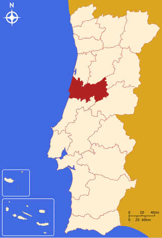
Coimbra District is located in the Centro Region, Portugal. The district capital is the city of Coimbra.
The Comunidade Intermunicipal da Região de Coimbra is an administrative division in Portugal. It was created in October 2013, replacing the previously existing Greater Metropolitan Area of Coimbra. Since January 2015, Região de Coimbra is also a NUTS3 subregion of Centro Region, that covers the same area as the intermunicipal community. The main city and seat of the intermunicipal community is Coimbra. The population in 2011 was 460,139, in an area of 4,335.57 km².
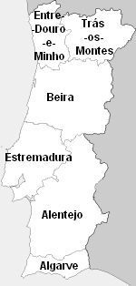
Beira was one of the six traditional provinces or comarcas of Portugal.
The Central Region or Central Portugal is one of the statistical regions of Portugal. The cities with major administrative status inside this region are Coimbra, Aveiro, Viseu, Caldas da Rainha, Leiria, Castelo Branco, Tomar, and Guarda. It is one of the seven Regions of Portugal. It is also one of the regions of Europe, as given by the European Union for statistical and geographical purposes. Its area totals 28,462 km2 (10,989 sq mi). As of 2011, its population totalled 2,327,026 inhabitants, with a population density of 82 inhabitants per square kilometre.

Soure is a town and municipality of the Coimbra District, in Portugal. The population in 2011 was 19,245, in an area of 265.06 km². It includes a castle listed as a national monument.

CP — Comboios de Portugal, EPE is a state-owned company which operates passenger trains in Portugal. Prior to June 2009, CP stood for Caminhos de Ferro Portugueses although the company has been using its current designation as a brand name since 2004.
The CP Urban Services network is the commuter train network of Metropolitan Lisbon and Metropolitan Porto, Portugal. It is a Comboios de Portugal company. It connects the city centers with the suburbs.

The Metro Mondego, part of the mass transit public transport system of Coimbra, Portugal, was to have been a light-rail network that runs above ground in Coimbra into the city's suburbs. Studies and planning were in progress but the Metro Mondego project was cancelled in January 2011 at the height of Portuguese financial crisis. The operational conventional rail line connecting the municipalities of: Coimbra, Miranda do Corvo, Lousã, and Serpins was closed at the same time and replaced by a bus service.

Beira Litoral is a former province (província) of Portugal, formally instituted in an administrative reform of 1936. It was abolished with the 1976 Constitution of Portugal.

The term "provinces" has been used throughout history to identify regions of continental Portugal. Current legal subdivisions of Portugal do not coincide with the provinces, but several provinces, in their 19th- and 20th-century versions, still correspond to culturally relevant, strongly self-identifying categories. They include:

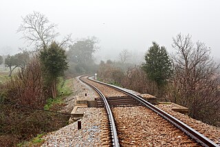
Ramal de Alfarelos is a railway branch in Portugal, which connects the Western Line to the Northern Line, offering a connection between Figueira da Foz and Coimbra.

Linha da Beira Alta is an international railway line which connects Pampilhosa on the Linha do Norte, close to Coimbra, to the border with Spain, at Vilar Formoso.
Infraestruturas de Portugal, S.A. (IP) is a state-owned company which resulted from the merger of Rede Ferroviária Nacional (REFER) and Estradas de Portugal (EP). It manages the Portuguese rail and road infrastructure.
Ramal de Cáceres is a closed Portuguese railway line which connected Torre das Vargens railway station, on the Linha do Leste, and Marvão-Beirã railway station, near to the border with Spain. It was completed on 15 October 1879, but was only opened on 6 June 1880. From 1881, the line was used as a faster alternative for international travelers between Portugal and Spain compared to the Linha do Leste, due to a better connection to the Spanish network. It was closed by REFER on 15 August 2012.

Ramal da Lousã is a railway line which connects the stations of Coimbra-B, on the Linha do Norte, and Coimbra, in Portugal. It was opened by the Companhia Real dos Caminhos de Ferro Portugueses, under the name Ramal de Coimbra, on 18 October 1885, and was extended to Lousã on 16 December 1906, and to Serpins on 10 August 1930.

António Tavares, is an Angolan–Portuguese author and writer. He is also a journalist, teacher and Portuguese politician.


