
Red Mesa is a census-designated place (CDP) in Apache County, Arizona, United States. The population was 480 at the 2010 census.

Rock Point is a census-designated place (CDP) in Apache County, Arizona, United States. The population was 642 at the 2010 census. Its name is descriptive of the point where Chinle Creek enters high sandstone walls.

Gadsden is a census-designated place (CDP) and colonia in Yuma County, Arizona, United States. The population was 953 at the 2000 census. It is part of the Yuma Metropolitan Statistical Area.

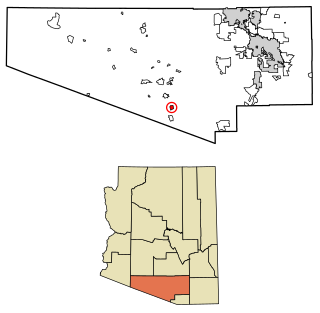
Tacna is a census-designated place (CDP) and colonia in Yuma County, Arizona, United States. The population was 555 at the 2000 census, and 602 as of 2010. It is part of the Yuma Metropolitan Statistical Area.
Red Rock is an unincorporated community and census-designated place (CDP) in Apache County, Arizona, United States. Red Rock is located on the Navajo Nation near the New Mexico border, 16 miles (26 km) northeast of Lukachukai. Red Rock has a post office with ZIP code 86544; the post office uses the Red Valley name. As of the 2010 census, the Red Rock CDP had a population of 169.

Avenue B and C or B&C Colonia is a census-designated place (CDP) and colonia in Yuma County, Arizona, United States. The population was 4,176 at the 2010 census. Areas that are part of Avenue B and C were first subdivided in the 1920s and 1930s. The colonia received a sewer system in 2011. It is the fifth most populous community in Yuma County and second most populous CDP.
Beyerville is a census-designated place (CDP) in Santa Cruz County, Arizona, United States. The population was 177 at the 2010 census.

East Verde Estates is a census-designated place in Gila County in the U.S. state of Arizona. East Verde Estates is located approximately six miles north of the town of Payson, off Arizona State Route 87. The population as of the 2010 U.S. Census was 170.
Orange Grove Mobile Manor is a census-designated place (CDP) and colonia in Yuma County, Arizona, United States. The population was 555 at the 2010 census. It is part of the Yuma Metropolitan Statistical Area.
Freedom Acres is a census-designated place (CDP) in Gila County, Arizona, United States. The population was 90 at the 2020 census, up from 84 at the 2010 census.
Mesa del Caballo is a census-designated place (CDP) in Gila County, Arizona, United States. The population was 765 at the 2010 census.
Washington Park is a census-designated place (CDP) in Gila County, Arizona, United States. The population was 70 at the 2010 United States Census.
Whispering Pines is a census-designated place (CDP) in Gila County, Arizona, United States. It is one of two locations in Arizona with this name, the other being a populated place in Greenlee County. The population was 148 at the 2010 United States Census.
Drysdale is a census-designated place (CDP) and colonia in Yuma County, Arizona, United States. The population was 272 at the 2010 census.
El Prado Estates is a census-designated place (CDP) and colonia in Yuma County, Arizona, United States. The population was 504 at the 2010 census.
Donovan Estates is a census-designated place (CDP) and colonia in Yuma County, Arizona, United States. The population was 1,508 at the 2010 census.
Padre Ranchitos is a census-designated place (CDP) and colonia situated near both the international border with Mexico, and the state border with California, in Yuma County, Arizona, United States. The population was 171 at the 2010 census.
South Komelik (O'odham) name translates as "South Flat", is a census-designated place in Pima County, in the U.S. state of Arizona. The population was 117 as of the 2020 census. It's located in the southern part of the Tohono O'odham Nation reservation near the border with Mexico.

Wall Lane is a census-designated place and colonia in Yuma County, in the U.S. state of Arizona. The population was 415 at the 2010 census.

Ventana is a census-designated place in Pima County, in the U.S. state of Arizona. The population was 52 at the 2020 census. The place takes it name from the Spanish word for "window" and is located in the northeastern part of the Tohono O'odham Nation reservation.


