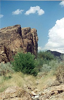
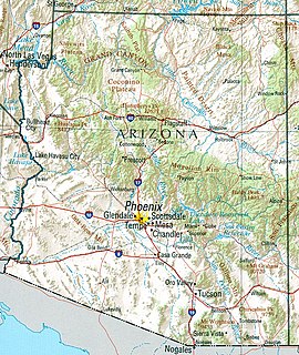
The Copper Mountains is a minor north–south trending mountain range, only 8 miles long in southwestern Arizona in the southwestern Sonoran Desert.

The Tinajas Altas Mountains are an extremely arid northwest-southeast trending mountain range in southern Yuma County, Arizona, approximately 35 mi southeast of Yuma, Arizona. The southern end of the range extends approximately one mile into the northwestern Mexican state of Sonora on the northern perimeter of the Gran Desierto de Altar. The range is about 22 mi in length and about 4 mi wide at its widest point. The highpoint of the range is unnamed and is 2,766 feet above sea level and is located at 32°16'26"N, 114°02'48"W. Aside from the portion of the range in Mexico, the entirety of the range lies within the Barry M. Goldwater Air Force Range. They lie at the heart of the traditional homeland of the Hia C-eḍ O'odham people.

The Muggins Mountains is a mountain range in southwest Arizona east of Yuma, Arizona, northeast of the Gila Mountains, and east of the Laguna Mountains. The Castle Dome Mountains lie to the northeast across the broad Castle Dome Plain. The Muggins Mountains Wilderness occupies the southwest portion of the range.

The Muggins Mountain Wilderness is a 7,711-acre (31.21 km2) wilderness area in the U.S. state of Arizona. It is located approximately 38 miles (61 km) east of Yuma, Arizona in the Muggins Mountains and adjacent to the agricultural Dome Valley and Gila River. The wilderness area is made up of the highest peak in the southern section of Muggins Mountains, Klothos Temple at 1,666 feet (508 m). Muggins Peak is adjacent to the peak southeastwards, at 1,424 feet (434 m). Three deeply cut washes drain the southwest border of the wilderness, Twin Tanks Wash, Muggins Wash, and Morgan Wash. Muggins Wash is the access point to the wilderness, by way of County 7th Street.
The Tank Mountains are a mountain range in the Sonoran Desert of southwest Arizona; the range is part of the southeastern border of the Kofa National Wildlife Refuge.

The Mohawk Valley is a valley in the lower regions of the western Gila River Valley in southwestern Arizona in the western Sonoran Desert.
The Bryan Mountains are a small mountain range in the northwestern Sonoran Desert of southwestern Arizona. The range is located in southeastern Yuma County, about 75 mi southeast of Yuma and about 35 mi west of Ajo. The range is approximately ten miles long and about three miles wide at its widest point. The highpoint of the range is 1,794 feet above sea level and is located at 32°18'27"N, 113°22'46"W. The range is located entirely within the Cabeza Prieta National Wildlife Refuge.
The San Cristobal Valley is a valley in the lower regions of the western Gila River Valley in southwestern Arizona in the western Sonoran Desert. The San Cristobal Wash drains northwest, but exists only in the southern half of the valley.

The Mohawk Mountains is a mountain range in the northwest Sonoran Desert of southwest Arizona. It abuts the western Gila River valley to the north, and is located in southern Yuma County. The Mohawk Valley lies adjacent and southwest of the range; the San Cristobal Valley is northeast.

The Gila Mountains of Yuma County are a 26-mile (42 km) long mountain range in southwestern Arizona in the northwest Sonoran Desert.

The Gila River Valley is a multi-sectioned valley of the Gila River, located primarily in Arizona. The Gila River forms in western New Mexico and flows west across southeastern, south-central, and southwestern Arizona; it changes directions as it progresses across the state, and defines specific areas and valleys. The central portion of the river flows through the southern Phoenix valley region, and the final sections in southwestern Arizona form smaller, irrigated valleys, such as Dome Valley, Mohawk Valley, and Hyder Valley.

Arizona is a landlocked state situated in the southwestern region of the United States of America. It has a vast and diverse geography famous for its deep canyons, high- and low-elevation deserts, numerous natural rock formations, and volcanic mountain ranges. Arizona shares land borders with Utah to the north, the Mexican state of Sonora to the south, New Mexico to the east, and Nevada to the northwest, as well as water borders with California and the Mexican state of Baja California to the southwest along the Colorado River. Arizona is also one of the Four Corners states and is diagonally adjacent to Colorado.
The Hyder Valley is a 20-mile (32 km) long valley section of the Gila River Valley west of Hyder on the Gila River. The valley is located north of Gila River in southwest Arizona in the northwestern Sonoran Desert. The Park Valley, which crosses the Gila borders to the southwest; the Hyder Valley is the access route to the Dendora Valley northeast which is on the western border of the Painted Rock Dam and Reservoir.
The San Cristobal Wash is an ephemeral wash and watercourse of the San Cristobal Valley, flowing north into the Gila River Valley of the southwestern desert region of Arizona. Besides Death Valley, the Chihuahuan Desert area, and regions of Baja Peninsula North America, the southeast California deserts along the Lower Colorado River Valley, this drainage region is in the harshest desert regions of North America.

The Growler Mountains is a 23-mile, (37-km) long north-south trending mountain range of far western Pima County, Arizona that lies 12 miles (19 km) west of Ajo, Arizona. This desert region of southern Arizona lies in the north and central Sonoran Desert, and is one of the drier desert areas of North America.
Tenmile Wash is an ephemeral wash and watercourse about 85 miles (137 km) long in the northern Sonoran Desert of south-central Arizona. It forms the eastern drainage of a two drainage system of dry washes into the Gila River Valley; both flow northwesterly, and the western drainage is the San Cristobal Wash Drainage of approximately the same length.

The Altar Valley is a 45-mile (72 km) long north–south valley, trending slightly northeast from Sasabe, Arizona on the Mexico border to the Avra Valley west of the Tucson Mountains. It is delimited by Arizona State Route 86, from east-to-west on the north separating it from the Avra Valley which then trends northwesterly, merging into the plains and drainage of the Santa Cruz River.
The Tonopah Desert is a small desert plains region of the Sonoran Desert, located west of Phoenix, Arizona. It is adjacent north of Interstate 10 and lies at the southwest intersection of the Hassayampa River with the Gila River. The Tonopah Desert is also just north of the Gila Bend Mountains massif which create the Gila Bend of the river.


