Rapids City, Illinois

Last updated

Rapids City
Rapid CIty, Illinois.jpg
Businesses along Illinois 84
Island County Illinois Incorporated and Unincorporated areas Rapids City Highlighted.svg
Location of Rapids City in Rock Island County, Illinois.
Illinois in United States (US48).svg
Location of Illinois in the United States
Coordinates: 41°34′52″N90°20′40″W / 41.58111°N 90.34444°W / 41.58111; -90.34444
CountryUnited States
StateIllinois
County Rock Island
Area
[1]
  Total1.63 sq mi (4.21 km2)
  Land1.63 sq mi (4.21 km2)
  Water0.00 sq mi (0.00 km2)
Population
 (2020)
  Total964
  Density592.87/sq mi (228.90/km2)
Time zone UTC-6 (CST)
  Summer (DST) UTC-5 (CDT)
ZIP Code(s)
61275
Area code 309
FIPS code 17-62822
Wikimedia CommonsRapids City, Illinois
Website www.rapidscity.us

Rapids City is a village in Rock Island County, Illinois, United States. The population was 964 at the time of the 2020 census [2] ; up from 959 at the 2010 census.

Contents

Geography

Location of Rapids City, Illinois ILMap-doton-RapidsCity.PNG
Location of Rapids City, Illinois

Rapids City is located at 41°34′52″N90°20′40″W / 41.58111°N 90.34444°W / 41.58111; -90.34444 (41.581083, -90.344324). [3]

According to the 2010 census, Rapids City has a total area of 1.62 square miles (4.20 km2), all land. [4]

Demographics

Historical population
CensusPop.Note
1880 920
1890 288−68.7%
1900 212−26.4%
1910 143−32.5%
1920 142−0.7%
1930 19940.1%
1940 27538.2%
1950 48777.1%
1960 67538.6%
1970 656−2.8%
1980 1,05861.3%
1990 932−11.9%
2000 9532.3%
2010 9590.6%
2020 9640.5%
U.S. Decennial Census [5]

As of the census [6] of 2000, there were 953 people, 352 households, and 280 families residing in the village. The population density was 623.0 inhabitants per square mile (240.5/km2). There were 367 housing units at an average density of 239.9 per square mile (92.6/km2). The racial makeup of the village was 98.53% White, 0.10% Asian, 0.10% Pacific Islander, 0.52% from other races, and 0.73% from two or more races. Hispanic or Latino of any race were 2.10% of the population.

There were 352 households, out of which 34.1% had children under the age of 18 living with them, 70.2% were married couples living together, 5.7% had a female householder with no husband present, and 20.2% were non-families. 16.2% of all households were made up of individuals, and 5.4% had someone living alone who was 65 years of age or older. The average household size was 2.71 and the average family size was 3.05.

In the village, the population was spread out, with 25.1% under the age of 18, 7.7% from 18 to 24, 28.3% from 25 to 44, 29.5% from 45 to 64, and 9.4% who were 65 years of age or older. The median age was 39 years. For every 100 females, there were 100.6 males. For every 100 females age 18 and over, there were 97.2 males.

The median income for a household in the village was $44,474, and the median income for a family was $50,893. Males had a median income of $43,125 versus $24,808 for females. The per capita income for the village was $24,499. About 0.8% of families and 3.0% of the population were below the poverty line, including 4.8% of those under age 18 and none of those age 65 or over.

Related Research Articles

<span class="mw-page-title-main">Cleveland, Illinois</span> Village in Illinois, United States

Cleveland is a village in Henry County, Illinois, United States. The population was 188 at the 2010 census, down from 253 in 2000.

<span class="mw-page-title-main">Matherville, Illinois</span> Village in Illinois, United States

Matherville is a village in Mercer County, Illinois, United States. The population was 707 at the 2020 census.

<span class="mw-page-title-main">North Henderson, Illinois</span> Village in Illinois, United States

North Henderson is a village in Mercer County, Illinois, United States. The population was 162 at the 2020 census.

<span class="mw-page-title-main">Andalusia, Illinois</span> Village in Illinois, United States

Andalusia is a village in Rock Island County, Illinois, United States. The population was 1,184 at the 2020 census, up from 1,178 at the 2010 census.

<span class="mw-page-title-main">Hampton, Illinois</span> Village in Illinois, United States

Hampton is a village in Rock Island County, Illinois, United States. The population was 1,779 at the time of the 2020 census. down from 1,863 at the 2010 census.

<span class="mw-page-title-main">Hillsdale, Illinois</span> Village in Illinois, United States

Hillsdale is a village in Rock Island County, Illinois, United States. The population was 531 at the time of the 2020 census, up from 523 at the 2010 census.

<span class="mw-page-title-main">Erie, Illinois</span> Village in Illinois, United States

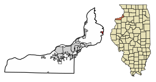
Erie is a village in Whiteside County, Illinois, United States. The population was 1,602 at the 2010 census, up from 1,589 in 2000. It is known for its unusual layout, specifically its "town triangle".

<span class="mw-page-title-main">Guernsey, Iowa</span> City in Iowa, United States

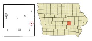
Guernsey is a town in Poweshiek County, Iowa, United States. The population was 63 at the time of the 2020 census.

<span class="mw-page-title-main">Mashpee Neck, Massachusetts</span> Census-designated place in Massachusetts, United States

Mashpee Neck is a census-designated place (CDP) in the town of Mashpee in Barnstable County, Massachusetts, United States. The population was 1,000 at the 2010 census. It is the most populous of the seven CDPs in Mashpee.

<span class="mw-page-title-main">Maple Rapids, Michigan</span> Village in Michigan, United States

Maple Rapids is a village in Clinton County in the U.S. state of Michigan. The population was 672 at the 2010 census. The village is located in Essex Township about 10 miles (16.1 km) northwest of St. Johns. A portion of the village is within the Maple River State Game Area.

<span class="mw-page-title-main">Grand Rapids Charter Township, Michigan</span> Charter township in Michigan, United States

Grand Rapids Charter Township is a charter township of Kent County in the U.S. state of Michigan. The population was 16,661 at the 2010 census.

<span class="mw-page-title-main">Grand Rapids, Ohio</span> Village in Ohio, USA

Grand Rapids is a village in Grand Rapids Township, Wood County, Ohio, United States, along the Maumee River. The population was 925 at the 2020 census. Grand Rapids is served by a branch of the Weston Public Library.

<span class="mw-page-title-main">Williamstown, Pennsylvania</span> Borough in Pennsylvania, United States

Williamstown is a borough in Dauphin County, Pennsylvania, United States. The borough is 38 miles (61 km) northeast of Harrisburg. Formerly, anthracite coal mines and hosiery mills were located in the borough. The population was 1,303 at the 2020 census.

<span class="mw-page-title-main">Butternut, Wisconsin</span> Village in Wisconsin, United States

Butternut is a village in Ashland County in the U.S. state of Wisconsin. The population was 375 at the 2010 census.

<span class="mw-page-title-main">Steuben, Wisconsin</span> Village in Wisconsin, United States

Steuben is a village in Crawford County, Wisconsin, United States. The population was 131 at the 2010 census.

<span class="mw-page-title-main">Tennyson, Wisconsin</span> Village in Wisconsin, United States

Tennyson is a village in Grant County, Wisconsin, United States, originally called Dutch Hollow. The population was 355 at the 2010 census.

<span class="mw-page-title-main">Rewey, Wisconsin</span> Village in Wisconsin, United States

Rewey is a village in Iowa County, Wisconsin, United States. The population was 292 at the 2010 census. It is part of the Madison Metropolitan Statistical Area.

<span class="mw-page-title-main">Boaz, Wisconsin</span> Village in Wisconsin, United States

Boaz is a village in Richland County, Wisconsin, United States. According to the 2010 census, the population of the village was 156.

<span class="mw-page-title-main">La Farge, Wisconsin</span> Village in Wisconsin, United States

La Farge is a village along the Kickapoo River in Vernon County, Wisconsin, United States. Its population was 730 at the 2020 census.

<span class="mw-page-title-main">Oakdale, Wisconsin</span> Village in Wisconsin, United States

Oakdale is a village in Monroe County, Wisconsin, United States. The population was 302 at the 2020 census. The village is located within the Town of Oakdale.

References

  1. "2020 U.S. Gazetteer Files". United States Census Bureau. Retrieved March 15, 2022.
  2. "Census of Population and Housing". Census.gov. Retrieved January 8, 2024.
  3. "US Gazetteer files: 2010, 2000, and 1990". United States Census Bureau. February 12, 2011. Retrieved April 23, 2011.
  4. "G001 - Geographic Identifiers - 2010 Census Summary File 1". United States Census Bureau. Archived from the original on February 13, 2020. Retrieved December 25, 2015.
  5. "Census of Population and Housing". Census.gov. Retrieved June 4, 2015.
  6. "U.S. Census website". United States Census Bureau . Retrieved January 31, 2008.