
York County is a county in the U.S. state of South Carolina. As of the 2020 Census, the population was 282,090, making it the seventh most populous county in the state. Its county seat is the city of York, and its largest city is Rock Hill. The county is served by one interstate highway, I-77.

Horry County is the easternmost county in the U.S. state of South Carolina. As of the 2020 census, its population was 351,029. It is the fourth-most populous county in South Carolina. The county seat is Conway.

Surry County is a county located in the U.S. state of North Carolina. As of the 2020 Census, the population was 71,359. Its county seat is Dobson, and its largest city is Mount Airy.

Chatham County is a county located in the Piedmont area of the U.S. state of North Carolina. As of the 2020 census, the population was 76,285. Its county seat is Pittsboro.

White County is a county located in the U.S. state of Arkansas. As of the 2010 census, the population was 77,076. The county seat is Searcy. White County is Arkansas's 31st county, formed on October 23, 1835, from portions of Independence, Jackson, and Pulaski counties and named for Hugh Lawson White, a Whig candidate for President of the United States. It is an alcohol prohibition or dry county, though a few private establishments can serve alcohol.

Cullowhee is a census-designated place (CDP) in Jackson County, North Carolina, United States. It is located on the Tuckasegee River, and the permanent population was 7,682 at the 2020 census up form 6,228 at the 2010 census.

Beaufort is a city in and the county seat of Beaufort County, South Carolina, United States. Chartered in 1711, it is the second-oldest city in South Carolina, behind Charleston. The city's population was 12,361 in the 2010 census. It is a primary city within the Hilton Head Island-Bluffton-Beaufort, SC Metropolitan Statistical Area.

Port Royal is a town on Port Royal Island in Beaufort County, South Carolina, United States. Largely because of annexation of surrounding areas, the population of Port Royal rose from 3,950 in 2000 to 10,678 in 2010, a 170% increase. As defined by the U.S. Census Bureau, Port Royal is included within the Hilton Head Island-Bluffton-Beaufort, SC Metropolitan Statistical Area. Port Royal is home to Marine Corps Recruit Depot Parris Island and Naval Hospital Beaufort.

Hardeeville is a city in Jasper and Beaufort counties in the U.S. state of South Carolina. The population was 7,473 as of the 2020 census, an increase of over 150% since 2010. Hardeeville is included within the Hilton Head Island-Bluffton-Beaufort, SC Metropolitan Statistical Area.

Rock Hill is the largest city in York County, South Carolina, United States, and the fifth-largest city in the state. It is also the fourth-largest city of the Charlotte metropolitan area, behind Charlotte, Concord, and Gastonia. As of the 2020 Census, the population was 74,372. As of 2017, the total population of the Rock Hill Census County Division was estimated at 117,375 people.

Kirkby Stephen is a market town and civil parish in Cumbria, North West England. Historically part of Westmorland, it lies on the A685, surrounded by sparsely populated hill country, about 25 miles (40 km) from the nearest larger towns: Kendal and Penrith. The River Eden rises 6 miles (9.7 km) away in the peat bogs below Hugh Seat and passes the eastern edge of the town. At the 2001 census the parish had a population of 1,832. In 2011, it had a population of 1,522.

Glassell Park is a neighborhood of Northeast Los Angeles, California, in the San Rafael Hills.

West End Village is a neighborhood in Pittsburgh, Pennsylvania's west city area. It has a zip code of 15220, and has representation on Pittsburgh City Council by the council member for District 2.

Western North Carolina is the region of North Carolina which includes the Appalachian Mountains; it is often known geographically as the state's Mountain Region. It contains the highest mountains in the Eastern United States, with 125 peaks rising to over 5,000 feet in elevation. Mount Mitchell at 6,684 feet, is the highest peak of the Appalachian Mountains and mainland eastern North America. The population of the region, as measured by the 2010 U.S. Census, is 1,473,241, which is approximately 15% of North Carolina's total population.

There are more than 500 neighborhoods within the area of Jacksonville, Florida, the largest city in the contiguous United States by area. These include Downtown Jacksonville and surrounding neighborhoods. Additionally, greater Jacksonville is traditionally divided into several major sections with amorphous boundaries: Northside, Westside, Southside, and Arlington, as well as the Jacksonville Beaches.

The amalgamation of Toronto was the creation of the political borders of Toronto, Ontario, Canada after amalgamating, annexing, and merging with surrounding municipalities since the 18th century. The most recent occurrence of amalgamation was in 1998, which resulted in Toronto's current boundaries.
Bannertown is an unincorporated community in Surry County, North Carolina, United States, just outside the city of Mount Airy. The community is centered on the intersection of Business U.S. Highway 52 and North Carolina Highway 89. Some of the area, specifically from the center of the community to the Ararat River has been annexed by Mount Airy in recent years.

The Culture of North Carolina is a subculture in the United States. As one of the original Thirteen Colonies, North Carolina culture has been greatly influenced by early settlers of English, Scotch-Irish, Scotch, German, and Swiss descent. Likewise, African Americans have had great cultural influence in North Carolina, first coming as enslaved people during colonial times. From slavery to freedom, they have helped shape things such as literary traditions, religious practices, cuisine, music, and popular culture.

The Charlotte metropolitan area, sometimes referred to as Metrolina, is a metropolitan area of the U.S. states of North and South Carolina, within and surrounding the city of Charlotte. The metropolitan area also includes the cities of Gastonia, Concord, Huntersville, and Rock Hill as well as the large suburban area in the counties surrounding Mecklenburg County, which is at the center of the metro area. Located in the Piedmont, it is the largest metropolitan area in the Carolinas, and the fourth largest in the Southeastern United States. The Charlotte metropolitan area is one of the fastest growing metropolitan areas in the United States.
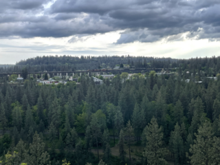
West Hills is a neighborhood in Spokane, Washington. As the name suggests, the neighborhood is located on hillsides to the west of downtown Spokane. The neighborhood also extends far to the west along the West Plains to incorporate the Spokane International Airport and surrounding land. As the city has grown over the decades, the West Hills neighborhood has expanded uphill and onto the plains to the west. That history of incremental growth, combined with the hilly topography of the area cut by numerous watercourses, has broken up the neighborhood into multiple, distinct areas with swaths of undeveloped land mixed in between.


