Sharon, South Carolina

Last updated

Sharon, South Carolina
SCMap-doton-Sharon.PNG
Location of Sharon, South Carolina
Coordinates: 34°57′6″N81°20′22″W / 34.95167°N 81.33944°W / 34.95167; -81.33944
Country United States
State South Carolina
County York
Area
[1]
  Total1.31 sq mi (3.39 km2)
  Land1.31 sq mi (3.39 km2)
  Water0.00 sq mi (0.00 km2)
Elevation
[2]
653 ft (199 m)
Population
 (2020) [3]
  Total462
  Density352.67/sq mi (136.14/km2)
Time zone UTC-5 (Eastern (EST))
  Summer (DST) UTC-4 (EDT)
ZIP code
29742
Area code(s) 803, 839
FIPS code 45-65410 [4]
GNIS feature ID1226537 [2]

Sharon is a town in southwestern York County, South Carolina, United States. The population was 494 at the 2010 census.

Contents

History

The Hill Complex Historic District, W.L. Hill Store, and Sharon Downtown Historic District are listed on the National Register of Historic Places. [5]

Geography

Sharon is located at 34°57′6″N81°20′22″W / 34.95167°N 81.33944°W / 34.95167; -81.33944 (34.951565, -81.339360). [6]

According to the United States Census Bureau, the town has a total area of 1.3 square miles (3.4 km2), all land.

Demographics

Historical population
CensusPop.Note
1900 150
1910 374149.3%
1920 41912.0%
1930 324−22.7%
1940 38819.8%
1950 365−5.9%
1960 280−23.3%
1970 268−4.3%
1980 32320.5%
1990 270−16.4%
2000 42155.9%
2010 49417.3%
2020 462−6.5%
U.S. Decennial Census [7] [3]

As of the census [4] of 2000, there were 421 people, 149 households, and 113 families residing in the town. The population density was 329.7 inhabitants per square mile (127.3/km2). There were 161 housing units at an average density of 126.1 per square mile (48.7/km2). The racial makeup of the town was 94.54% White, 3.80% African American, 0.95% Native American, and 0.71% from two or more races.

There were 149 households, out of which 35.6% had children under the age of 18 living with them, 63.8% were married couples living together, 9.4% had a female householder with no husband present, and 23.5% were non-families. 19.5% of all households were made up of individuals, and 10.1% had someone living alone who was 65 years of age or older. The average household size was 2.83 and the average family size was 3.25.

In the town, the population was spread out, with 28.5% under the age of 18, 8.8% from 18 to 24, 27.1% from 25 to 44, 23.3% from 45 to 64, and 12.4% who were 65 years of age or older. The median age was 34 years. For every 100 females, there were 96.7 males. For every 100 females age 18 and over, there were 92.9 males.

The median income for a household in the town was $35,250, and the median income for a family was $36,875. Males had a median income of $26,071 versus $21,250 for females. The per capita income for the town was $13,798. About 7.3% of families and 8.8% of the population were below the poverty line, including 10.4% of those under age 18 and 7.4% of those age 65 or over.

Miscellany

Sharon is the location of the highest building in the southwestern section of the county, in the former Hill's Mercantile, made from bricks which were fired on-site, at the turn of the 19th and 20th centuries. Sharon is home to the former First National Bank of Sharon incorporated 1889. From 1910 to 1929 the U.S. Bureau of Engraving produced national bank notes for it. It was the only bank in Western York County to survive the Depression. At the time of its merger in 1986 with the First Citizens Bank and Trust of South Carolina, it was the oldest continuously operating national in York County. The Bank's distinctive architecture helped to get it placed in the National Register of Historic Places in 2001.

Related Research Articles

<span class="mw-page-title-main">Pinetops, North Carolina</span> Town in North Carolina, United States

Pinetops is a town in Edgecombe County, North Carolina, United States. It is part of the Rocky Mount, North Carolina Metropolitan Statistical Area. The population was 1,374 at the 2010 census.

<span class="mw-page-title-main">Spring Hope, North Carolina</span> Town in North Carolina, United States

Spring Hope is a town in Nash County, North Carolina, United States. It is part of the Rocky Mount, North Carolina Metropolitan Statistical Area. The population was 1,320 at the 2010 census.

Orrum is a town in Robeson County, North Carolina, United States. The population was 91 at the 2010 census.

<span class="mw-page-title-main">Pilot Mountain, North Carolina</span> Town in North Carolina, United States

Pilot Mountain is a town in Surry County, North Carolina, United States. The population was 1,443 at the 2020 census. It is named for the nearby landmark of Pilot Mountain, a distinctive geological formation.

<span class="mw-page-title-main">Donalds, South Carolina</span> Town in South Carolina, United States

Donalds is a town in Abbeville County, South Carolina. As of the 2020 United States Census, its population was 328.

<span class="mw-page-title-main">Fairfax, South Carolina</span> Town in South Carolina, United States

Fairfax is a town in Allendale and Hampton counties, South Carolina, United States. The population was 2,025 at the 2010 census, a decline of over one-third of its population of 3,206 from 2000.

<span class="mw-page-title-main">Lowrys, South Carolina</span> Town in South Carolina, United States

Lowrys is a small rural town in Chester County, South Carolina, United States. The population was 200 at the 2010 census.

<span class="mw-page-title-main">Richburg, South Carolina</span> Town in South Carolina, United States

Richburg is a town in Chester County, South Carolina, United States. The population was 275 at the 2010 census, down from 332 at the 2000 census.

<span class="mw-page-title-main">Trenton, South Carolina</span> Town in South Carolina, United States

Trenton is a town in Edgefield County, South Carolina, United States. The population was 196 at the 2010 census, down from 226 in 2000.

<span class="mw-page-title-main">Gray Court, South Carolina</span> Town in South Carolina, United States

Gray Court is a town in Laurens County, South Carolina, United States. The population was 795 at the 2010 census. It is part of the Greenville–Mauldin–Easley Metropolitan Statistical Area.

<span class="mw-page-title-main">Pomaria, South Carolina</span> Town in South Carolina, United States

Pomaria is a town in Newberry County, South Carolina, United States. The population was 179 at the 2010 census.

<span class="mw-page-title-main">Prosperity, South Carolina</span> Town in South Carolina, United States

Prosperity is a town in Newberry County, South Carolina, United States. The population was 1,178 at the 2020 U.S. census.

<span class="mw-page-title-main">Saluda, South Carolina</span> Town in South Carolina, United States

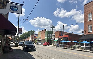
Saluda is a town in Saluda County, South Carolina, United States, along the Little Saluda River. The population was 3,565 at the 2010 census. It is the county seat of Saluda County.

<span class="mw-page-title-main">Roebuck, South Carolina</span> CDP in South Carolina, United States

Roebuck is a census-designated place (CDP) in Spartanburg County, South Carolina, United States. The population was 2,200 at the 2010 census.

<span class="mw-page-title-main">Wellford, South Carolina</span> City in South Carolina, United States

Wellford is a city in Spartanburg County, South Carolina, United States. The population was 3,293 at the 2020 census, up from 2,378 in 2010.

<span class="mw-page-title-main">Carlisle, South Carolina</span> Town in South Carolina, United States

Carlisle is a town in Union County, South Carolina, United States. The population was 436 according to the 2010 United States Census.

<span class="mw-page-title-main">Jonesville, South Carolina</span> City in South Carolina, United States

Jonesville is a town in Union County, South Carolina, United States. The population was 911 at the 2010 United States Census.

<span class="mw-page-title-main">Lockhart, South Carolina</span> Town in South Carolina, United States

Lockhart is a town in Union County, South Carolina, United States. The population was 488 at the 2010 United States Census.

<span class="mw-page-title-main">McConnells, South Carolina</span> Town in South Carolina, United States

McConnells is a town in York County, South Carolina, United States and a suburb of York. The population was 255 at the 2010 census.

<span class="mw-page-title-main">York, South Carolina</span> City in South Carolina, United States

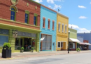
York is a city in and county seat of York County, South Carolina, United States. The population was approximately 6,985 at the 2000 census and up to 7,736 at the 2010 census. York is located approximately 27 miles (43 km) southwest of Charlotte, North Carolina and 13 miles (21 km) west of Rock Hill, South Carolina.

References

  1. "ArcGIS REST Services Directory". United States Census Bureau. Retrieved October 15, 2022.
  2. 1 2 U.S. Geological Survey Geographic Names Information System: Sharon, South Carolina
  3. 1 2 "Census Population API". United States Census Bureau. Retrieved October 15, 2022.
  4. 1 2 "U.S. Census website". United States Census Bureau . Retrieved January 31, 2008.
  5. "National Register Information System". National Register of Historic Places . National Park Service. July 9, 2010.
  6. "US Gazetteer files: 2010, 2000, and 1990". United States Census Bureau. February 12, 2011. Retrieved April 23, 2011.
  7. "Census of Population and Housing". Census.gov. Retrieved June 4, 2015.