Tega Cay, South Carolina

Last updated

Tega Cay, South Carolina
City of Tega Cay
Tega Cay, SC City Seal.jpg
Motto: 
"The Good Life"
SCMap-doton-TegaCay.PNG
Location of Tega Cay, South Carolina
Coordinates: 35°2′14″N81°1′29″W / 35.03722°N 81.02472°W / 35.03722; -81.02472
Country Flag of the United States (23px).png  United States
State Flag of South Carolina.svg  South Carolina
County York
Government
  TypeCity
  MayorChris Gray
  Mayor Pro TemThomas Hyslip
  Council MemberRyan Richard
  Council MemberGus Matchunis
  Council MemberScott Shirley
Area
[1]
  Total4.50 sq mi (11.64 km2)
  Land4.49 sq mi (11.62 km2)
  Water0.01 sq mi (0.02 km2)
Elevation
[2]
627 ft (191 m)
Population
 (2020) [3]
  Total12,832
  Density2,859.18/sq mi (1,103.99/km2)
Time zone UTC-5 (Eastern (EST))
  Summer (DST) UTC-4 (EDT)
ZIP codes
29708
Area code(s) 803, 839
FIPS code 45-71417 [4]
GNIS feature ID1231854 [2]
Website www.tegacaysc.org

Tega Cay is a planned city in York County, South Carolina, United States, located west of Fort Mill and north of Rock Hill. It is a suburb of Charlotte, North Carolina. The population was recorded at 12,832 as of the 2020 U.S. Census.

Contents

Tega Cay is located on a peninsula along Lake Wylie, twenty miles south of Charlotte. The name Tega Cay allegedly comes from an unknown Polynesian language and means "Beautiful Peninsula", however, this is unconfirmed. [5]

Geography and climate

Tega Cay is located at 35°2′14″N81°1′29″W / 35.03722°N 81.02472°W / 35.03722; -81.02472 (35.037262, -81.024644). [6] According to the United States Census Bureau, the city has a total area of 3.2 square miles (8.2 km2), of which 2.5 square miles (6.4 km2) is land and 0.7 square mile (1.7 km2) (21.27%) is water. The city has 13 mi (21 km) of shoreline. Tega Cay's ZIP code is 29708 and the area code is 803. The hilly terrain is densely forested, containing many species of hardwoods and pines, and wildlife. Recreational facilities located in Tega Cay include a public 27-hole, award winning golf course with a clubhouse and pavilion, a croquet court, and seven lighted tennis courts, two lighted pickleball courts, several miles of walking trails, and thirteen city owned parks of which three have baseball and/or soccer fields available for public use. Two of the parks are lake side and the City owns swimming pool facility (membership only) that is also adjacent to Lake Wylie. Along with those lakeside amenities, there is a privately owned marina, and three areas to launch boats. [7] The City is currently engineering and fundraising for a 62-acre park for passive and active recreation along the Catawba River. Included at that park will be miles of walking trails, four baseball/softball diamonds, six youth soccer fields, inclusive playgrounds, an amphitheater and a paddle boat launch onto the river just below the Lake Wylie hydro-electric dam. The climate of Tega Cay is that of a Humid subtropical climate, which is characterized by hot, humid summers and cool, dry winters. Snow falls 3-4 times a year on average.

Government

Tega Cay City Hall Tega Cay City Hall, Tega Cay, SC.jpg
Tega Cay City Hall

Tega Cay is run under a council–manager government framework. The City Manager is chief executive position in this form of Government. The Council of Tega Cay is composed of four members plus the Mayor who serves as a member of Council, selected from at-large districts. The city maintains its own Police Department, Fire Department, Parks & Recreation Department, Development Services Department, Utilities Department (water & waste water) and Public Works Department. Other positions in the town include Assistant City Manager, Finance Director, Municipal Clerk, Clerk of Court, Planning & Development Manager, Building Inspectors, and administrative staff. [7]

The City has a Fire Department with an ISO rating of 2. Several other governmental positions in the town, including the Beautification Committee, the Planning Commission, the Storm Water Committee and the Board of Zoning Appeals, are all staffed by volunteers as well. Based on the mini-cities concept, trash collection, curbside recycling, repaving and similar requirements are contracted out. The fiscal year runs from October 1 through September 30. [7]

The current mayor is Chris Gray, who was sworn on January 3, 2022. [8]

Fort Mill is currently represented by the following legislators:

Demographics

Historical population
CensusPop.Note
1990 3,016
2000 4,04434.1%
2010 7,62088.4%
2020 12,83268.4%
U.S. Decennial Census [9] [3]

2020 census

Tega Cay racial composition [10]
RaceNum.Perc.
White (non-Hispanic)10,00877.99%
Black or African American (non-Hispanic)5254.09%
Native American 160.12%
Asian 9497.4%
Pacific Islander 30.02%
Other/Mixed 6044.71%
Hispanic or Latino 7275.67%

As of the 2020 United States census, there were 12,832 people, 3,531 households, and 3,013 families residing in the city.

2000 census

As of the census [4] of 2000, there were 4,044 people, 1,509 households, and 1,228 families residing in the city. The population density was 1,630 inhabitants per square mile (630/km2). There were 1,577 housing units at an average density of 635.7 per square mile (245.4/km2). The racial makeup of the city was 95.87% White, 2.13% African American, 0.82% Asian, 0.12% Native American, 0.10% Pacific Islander, 0.37% from other races, and 0.59% from two or more races. Hispanic or Latino within any race were 0.91% of the population.

There were 1,509 households, out of which 37.6% had children under the age of 18 living with them, 74.6% were married couples living together, 5.2% had a female householder with no husband present, and 18.6% were non-families. 15.0% of all households were made up of individuals, and 4.0% had someone living alone who was 65 years of age or older. The average household size was 2.68 and the average family size was 2.99.

In the city, the population was spread out, with 26.8% under the age of 18, 4.3% from 18 to 24, 29.1% from 25 to 44, 30.6% from 45 to 64, and 9.2% who were 65 years of age or older. The median age was 40 years. For every 100 females, there were 93.4 males. For every 100 females age 18 and over, there were 93.8 males.

The median income for a household in the city was $80,227, and the median income for a family was $82,926. Males had a median income of $61,745 versus $35,082 for females. The per capita income for the city was $37,275. About 1.3% of families and 1.2% of the population were below the poverty line, including 2.1% of those under age 18 and none of those age 65 or over.

Students attend Fort Mill schools, which are located nearby and are considered among the best in the state. [7] [11]

Media

Tega Cay is home to a newspaper, The Tega Cay Sun, which covers the area. The Tega Cay Sun started as a daily online newspaper and is now printed monthly. [12] Magazines include Life in the Cay and 29708.

Notable People

See also

Related Research Articles

<span class="mw-page-title-main">York County, South Carolina</span> County in South Carolina, United States

York County is a county on the north central border in the U.S. state of South Carolina. As of the 2020 census, the population was 282,090, making it the seventh-most populous county in the state. Its county seat is the city of York, and its most populous community is Rock Hill. The county is served by one Interstate Highway, Interstate 77.

<span class="mw-page-title-main">Chester County, South Carolina</span> County in South Carolina, United States

Chester County is a county located in the U.S. state of South Carolina. As of the 2020 census, its population was 32,294. Its county seat is Chester.

<span class="mw-page-title-main">Holcomb, Missouri</span> City in Missouri, United States

HolcombHAW-kəm is a city in Dunklin County, Missouri, United States. The population was 635 at the 2010 census.

<span class="mw-page-title-main">Broken Bow, Nebraska</span> City in Nebraska

Broken Bow is a city in Custer County, Nebraska, United States. The population was 3,559 at the 2010 census. It is the county seat of Custer County.

<span class="mw-page-title-main">Ralston, Nebraska</span> City in Douglas County, Nebraska, United States

Ralston is a city in Douglas County, Nebraska, United States. The population was 6,494 at the 2020 census. A suburb of Omaha, Ralston is surrounded on three sides by the city of Omaha by 84th, 72nd, and L Streets, and by Sarpy County on the south side.

<span class="mw-page-title-main">Belmont, North Carolina</span> City in North Carolina, United States

Belmont is a small suburban city in Gaston County, North Carolina, United States, located about 9 miles (14 km) east of Gastonia. The population was 10,076 at the 2010 census. Once known as Garibaldi Station, it was named for the New York banker August Belmont. Belmont is home to Belmont Abbey College.

<span class="mw-page-title-main">Perry Township, Armstrong County, Pennsylvania</span> Township in Pennsylvania, United States

Perry Township is a township that is located in Armstrong County, Pennsylvania, United States. The population was 367 at the time of the 2020 census, an increase over the figure of 352 that was tabulated in 2010.

<span class="mw-page-title-main">Beallsville, Pennsylvania</span> Borough in Pennsylvania, United States

Beallsville is a borough in Washington County, Pennsylvania, United States and part of the Pittsburgh metropolitan area since 1950. The population was 392 at the 2020 census. Much of the borough has been designated the Beallsville Historic District.

<span class="mw-page-title-main">Seneca, South Carolina</span> City in Oconee County, South Carolina

Seneca is a city in Oconee County, South Carolina, United States. The population was 8,102 at the 2010 census. It is the principal city of the Seneca Micropolitan Statistical Area, an (MSA) that includes all of Oconee County, and that is included within the greater Greenville-Spartanburg-Anderson, South Carolina Combined Statistical Area. Seneca was named for the nearby Cherokee town of Isunigu, which English colonists knew as "Seneca Town".

<span class="mw-page-title-main">Pickens, South Carolina</span> City in South Carolina, United States

Pickens, formerly called Pickens Courthouse, is a city in and the county seat of Pickens County, South Carolina, United States. The population was 3,126 at the 2010 census. Pickens changed its classification from a town to a city in 1998, but it was not reported to the Census Bureau until 2001. It was named after Andrew Pickens (1739–1817), an American revolutionary soldier and US Congressman for South Carolina.

<span class="mw-page-title-main">Forest Acres, South Carolina</span> City in South Carolina, United States

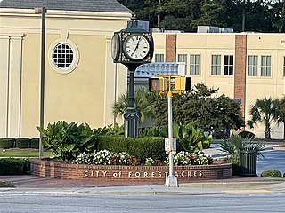
Forest Acres is a city in Richland County, South Carolina, United States. The population was 10,606 at the 2020 census. It is part of the Columbia, South Carolina, Metropolitan Statistical Area and is an enclave of the city of Columbia.

<span class="mw-page-title-main">Landrum, South Carolina</span> City in South Carolina, United States

Landrum is a city in Spartanburg County, South Carolina, United States. The population was 2,376 at the 2010 census.

<span class="mw-page-title-main">Woodruff, South Carolina</span> City in South Carolina, United States

Woodruff is a city in Spartanburg County, South Carolina, United States, located in upstate South Carolina. The population was 4,333 at the 2020 census.

<span class="mw-page-title-main">Fort Mill, South Carolina</span> Town in South Carolina, United States

Fort Mill, also known as Fort Mill Township, is a town in York County, South Carolina, United States. It is a suburb of Charlotte, North Carolina. As of the 2020 census, the population of the town was 24,521. Some businesses and residents in the Indian Land community of neighboring Lancaster County share a Fort Mill mailing address, but the official town boundary extends only within York County.

<span class="mw-page-title-main">Lake Wylie, South Carolina</span> CDP in South Carolina, United States

Lake Wylie is a census-designated place (CDP) in York County, South Carolina, United States. The population was 8,841 at the 2010 census. Lake Wylie is located on a peninsula along the shore of Lake Wylie, a reservoir that was named for Dr. W. Gil Wylie in 1960. It is a suburb of Charlotte, North Carolina.

<span class="mw-page-title-main">Poteet, Texas</span> City in Texas, United States

Poteet is a city in Atascosa County, Texas, United States. The population was 2,795 as of the 2020 census. It is part of the San Antonio Metropolitan Statistical Area. It was named for its first postmaster, Francis Marion Poteet. It is best known as the birthplace of country music legend George Strait.

<span class="mw-page-title-main">Lucas, Texas</span> City in Texas, United States

Lucas is a city in Collin County, Texas, United States. As of the 2010 census the population was 5,166, up from 2,890 at the 2000 census; in 2020, its population was 7,612.

<span class="mw-page-title-main">Chesnee, South Carolina</span> City in South Carolina, United States

Chesnee is a city in Spartanburg and Cherokee counties, in the U.S. state of South Carolina. The population was 868 as of the 2010 census.

<span class="mw-page-title-main">Ross Township, Edgar County, Illinois</span> Township in Illinois, United States

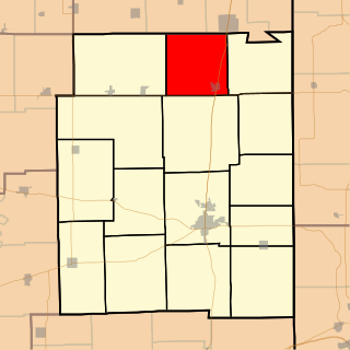
Ross Township is one of fifteen townships in Edgar County, Illinois, USA. As of the 2020 census, its population was 1,509 and it contained 653 housing units.

<span class="mw-page-title-main">Breese Township, Clinton County, Illinois</span> Township in Illinois, United States

Breese Township is one of fifteen townships in Clinton County, Illinois, USA. As of the 2020 census, its population was 5,594 and it contained 2,410 housing units.

References

  1. "ArcGIS REST Services Directory". United States Census Bureau. Retrieved October 15, 2022.
  2. 1 2 U.S. Geological Survey Geographic Names Information System: Tega Cay, South Carolina
  3. 1 2 "Census Population API". United States Census Bureau. Retrieved October 15, 2022.
  4. 1 2 "U.S. Census website". United States Census Bureau . Retrieved January 31, 2008.
  5. "Tega Cay". South Carolina Encyclopedia. Retrieved October 28, 2020.
  6. "US Gazetteer files: 2010, 2000, and 1990". United States Census Bureau. February 12, 2011. Retrieved April 23, 2011.
  7. 1 2 3 4 City of Tega Cay, South Carolina website. "Tega Cay, South Carolina". Archived from the original on June 9, 2007. Retrieved June 5, 2007.. Accessed June 4, 2007.
  8. Marks, John. "Chris Gray elected mayor of Tega Cay; more local election results". WRHI.com. WHRI.
  9. "Census of Population and Housing". Census.gov. Retrieved June 4, 2015.
  10. "Explore Census Data". data.census.gov. Retrieved December 15, 2021.
  11. Fort Mill School District, York 4, website. "Fort Mill School District - York 4 - District Facts". Archived from the original on June 8, 2008. Retrieved June 5, 2007.. Accessed June 4, 2007.
  12. https://tegacaysun.com/